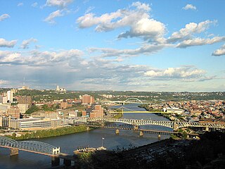
The Allegheny River is a 325-mile-long (523 km) headwater stream of the Ohio River that is located in western Pennsylvania and New York in the United States. It runs from its headwaters just below the middle of Pennsylvania's northern border, northwesterly into New York, then in a zigzag southwesterly across the border and through Western Pennsylvania to join the Monongahela River at the Forks of the Ohio at Point State Park in Downtown Pittsburgh, Pennsylvania.

The Monongahela River, sometimes referred to locally as the Mon, is a 130-mile-long (210 km) river on the Allegheny Plateau in north-central West Virginia and Southwestern Pennsylvania. The river flows from the confluence of its west and east forks in north-central West Virginia northeasterly into southwestern Pennsylvania, then northerly to Pittsburgh and its confluence with the Allegheny River to form the Ohio River. The river includes a series of locks and dams that makes it navigable.

The Stonycreek River is a tributary of the Conemaugh River, approximately 45 mi (72 km) long, in southwestern Pennsylvania in the United States.

Tulpehocken Creek is a 39.5-mile-long (63.6 km) tributary of the Schuylkill River in southeastern Pennsylvania in the United States, and during the American Canal Age, once provided nearly half the length of the Union Canal linking the port of Philadelphia, the largest American city and the other communities of Delaware Valley with the Susquehanna basin and the Pennsylvania Canal System connecting the Eastern seaboard to Lake Erie and the new settlements of the Northwest Territory via the Allegheny}, Monongahela. and Ohio Rivers at Pittsburgh.

The West Branch Susquehanna River is one of the two principal branches, along with the North Branch, of the Susquehanna River in the Northeastern United States. The North Branch, which rises in upstate New York, is generally regarded as the extension of the main branch, with the shorter West Branch being its principal tributary.
The Quemahoning Reservoir, also known to locals as The Dam, is created by the Quemahoning Dam, located on Quemahoning Creek on the border of Quemahoning Township, Conemaugh Township, and Jenner Township in Somerset County, Pennsylvania just south of Hollsopple.

The Main Line of Public Works was a package of legislation passed by the Commonwealth of Pennsylvania in 1826 to establish a means of transporting freight between Philadelphia and Pittsburgh. It funded the construction of various long-proposed canal and road projects, mostly in southern Pennsylvania, that became a canal system and later added railroads. Built between 1826 and 1834, it established the Pennsylvania Canal System and the Allegheny Portage Railroad.

Raystown Lake is a reservoir in Huntingdon County, Pennsylvania. It is the largest lake that is entirely within Pennsylvania. The original lake was built by the Simpson family of Huntingdon as a hydroelectric project. The current 8,300-acre (34 km2) Raystown Lake was completed in 1973 by the Army Corps of Engineers. Raystown is around 200 feet (61 m) deep in the deepest area near the dam. The lake was created primarily to control floods, provide electricity, and support recreational activities. Allegheny Electric Cooperative operates the Raystown Hydroelectric Project and William F. Matson Generating Station at the Raystown Dam, a 21 MW, two-unit hydroelectric project.

Anderson Creek is a 23.6-mile-long (38.0 km) tributary of the West Branch Susquehanna River in Clearfield County, Pennsylvania, in the United States.

The Pennsylvania Canal, sometimes known as the Pennsylvania Canal system, was a complex system of transportation infrastructure improvements, including canals, dams, locks, tow paths, aqueducts, and viaducts. The canal was constructed and assembled over several decades beginning in 1824, the year of the first enabling act and budget items.

The Beaver and Erie Canal, also known as the Erie Extension Canal, was part of the Pennsylvania Canal system and consisted of three sections: the Beaver Division, the Shenango Division, and the Conneaut Division. The canal ran 136 miles (219 km) north–south near the western edge of the state from the Ohio River to Lake Erie through Beaver County, Lawrence County, Mercer County, Crawford County, and Erie County, Pennsylvania.

The Allegheny River Lock and Dam No. 2 in Pittsburgh, Pennsylvania is a lock and fixed-crest dam from 1932. It crosses the Allegheny River between the Pittsburgh neighborhood of Highland Park and the suburb of Aspinwall. The lock and dam were built by the U.S. Army Corps of Engineers as a part of an extensive system of locks and dams to improve navigation along the Allegheny River. It is the most-used lock operated by the United States Army Corps of Engineers.


