Adjuntas is a small mountainside town and municipality in Puerto Rico located central midwestern portion of the island on the Cordillera Central, north of Yauco, Guayanilla, and Peñuelas; southeast of Utuado; east of Lares and Yauco; and northwest of Ponce. Adjuntas is spread over 16 barrios and Adjuntas Pueblo. Adjuntas is about two hours by car westward from the capital, San Juan.

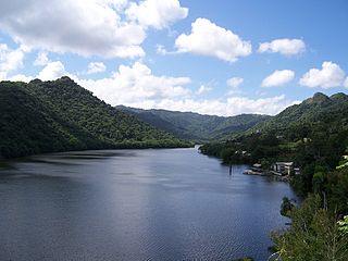
Trujillo Alto is a town and municipality of Puerto Rico located in the Northern Coastal Plain, on the boundary between the karst zone and Sierra de Luquillo, north of Caguas, and Gurabo; southeast of San Juan, and west of Carolina. Trujillo Alto is part of the San Juan Metropolitan Area, which includes the municipalities of Bayamón, Guaynabo, Cataño, and Toa Baja. The city is spread over 6 barrios and Trujillo Alto Pueblo. It is part of the San Juan-Caguas-Guaynabo Metropolitan Statistical Area.

Utuado is a town and municipality of Puerto Rico located in the central mountainous region of the island known as the Cordillera Central. It is located north of Adjuntas and Ponce; south of Hatillo and Arecibo; east of Lares; and west of Ciales and Jayuya. It is the third-largest municipality in land area in Puerto Rico. According to the 2020 US Census, the municipality has a population of 28,287 spread over 24 barrios and Utuado pueblo.

Villalba, originally known as Villa Alba, is town and municipality of Puerto Rico located in the central region, northeast of Juana Díaz; south of Orocovis; and west of Coamo. Villalba is spread over 6 barrios and Villalba Pueblo. It is part of the Ponce Metropolitan Statistical Area.

Cordillera Central, is the main mountain range in Puerto Rico. The range crosses the island from west to east and divides it into its northern and southern coastal plains. The Cordillera Central runs eastward from the municipality of Maricao in the west to Aibonito in the central eastern region, and on to the Caribbean in the southeast through the Sierra de Cayey. The Central Mountain Range consists of the Cordillera Central proper and numerous subranges, foothills and ridges that extend throughout the island. Cerro de Punta is both the highest peak of the Cordillera Central and the highest point in Puerto Rico. The Sierra de Luquillo, where El Yunque is located, is sometimes included as a subrange or eastward extension of the Cordillera Central.
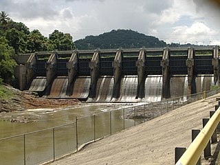
Dos Bocas Lake is a lake located in the municipalities of Arecibo and Utuado on the island of Puerto Rico. The lake was created from 1937 until it was completed in 1942 with the construction of the Dos Bocas Dam, by the Puerto Rico Electric Power Authority for a hydroelectric power plant. The building of the dam was a New Deal project. It also serves as one of the island's potable water reservoirs. In recent years, silt has accumulated in the lake causing capacity to shrink. Silt has also made some portions of the land inaccessible by boat.

Guajataca River is a river in Lares, Puerto Rico. It is located on the northwest coast of the island. It flows from the south and drains into the Atlantic Ocean. The name was given by the original Taino inhabitants prior to the arrival of Christopher Columbus.
Béisbol Doble A, governed by the Federación de Béisbol Aficionado de Puerto Rico, is a Puerto Rican amateur baseball spring and summer baseball league, founded in 1940 and based in San Juan. The season normally starts in mid to late February and ends with the Carnaval de Campeones final in September. They play a weekend schedule, and their all-star game is held soon after the regular season and before the playoffs. The Toritos de Cayey are the defending champions.

Guajataca Lake, or Lago Guajataca, is a reservoir of the Guajataca River created by the Puerto Rico Electric Power Authority in 1929. It is located between the municipalities of San Sebastián, Quebradillas, and Isabela in Puerto Rico, and receives most of its water from the Rio Guajataca and Rio Chiquito de Cibao rivers. The lake primarily functions as a water reservoir as well as for recreational activities such as boating and fishing. Various species of fish such as peacock bass, largemouth bass, sunfish, perch, catfish, tilapia and threadfin shad can be found in the lake. The Guajataka Scout Reservation partially borders the southern portion of the lake. The dam at Guajataca Lake experienced a structural failure on September 22, 2017, due to the hit from Hurricane Maria.
The Ruta Panorámica, officially the Ruta Panorámica Luis Muñoz Marín, is a 167-mile (269 km) network of some 40 secondary roads which traverse the island of Puerto Rico from west to east along its Cordillera Central. Most of the route consists of three roads, PR-105, PR-143, and PR-182. The route starts in Mayagüez and ends in Maunabo. The first major segment of the route runs from Mayagüez to Maricao as Route 105, then from Adjuntas to Aibonito as Route 143, and then follows Route 182 toward Maunabo.

The Río Grande de Arecibo is a river of Puerto Rico. The headwaters lie in the mountains to the south of Adjuntas. From there it flows north until it reaches the Atlantic Ocean near Arecibo. The tributaries lie along the side of the Cerro de Punta and the Utuado pluton. It flows through the northern, passing along a gorge that is 200 m deep and 800–1,200 m wide. It flows through the middle of Puerto Rico.

The Yauco River is a river that goes through Guayanilla and Yauco, municipalities in Puerto Rico.
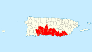
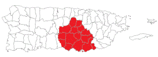
Porta Caribe is a tourism region in southern Puerto Rico. It was established in 2003 by the Puerto Rico Tourism Company, an agency of the Government of Puerto Rico. When created in 2003 it consisted of 14 municipalities in the south central zone. With the creation of the neighboring Porta Cordillera zone in July 2012, the municipalities of Adjuntas and Jayuya were transferred to the newly created Porta Cordillera zone and Porta Caribe became a 12-municipality tourism region. The name Porta Caribe translates to "Doorway to the Caribbean." Its executive director is Maritza W. Ruiz Cabán.
Puerto Rico Senatorial District VI, also known as the Senatorial District of Guayama, is one of the eight senatorial districts of Puerto Rico. It is currently represented by Miguel Pereira Castillo and Angel M. Rodríguez.
La Perla del Sur is a weekly regional Spanish-language newspaper based in Ponce, Puerto Rico. It is distributed in nine towns in southern Puerto Rico and has a circulation of 75,000. It also had an Internet portal where the entire printed version of the paper could be accessed. It was founded in 1983.
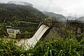
Carraízo Dam is a concrete gravity dam located in the municipality of Trujillo Alto, Puerto Rico within the flow of the Río Grande de Loíza. Its construction was completed in 1953. Carraízo Dam impounds Loíza Lake which serves as Puerto Rico's main water reservoir.
Miss Universe Puerto Rico 2017 was the 62nd Miss Universe Puerto Rico pageant. Brenda Jiménez of Aguadilla crowned Danna Hernández of San Juan at the end of the event. Hernández represented Puerto Rico at the Miss Universe 2017 pageant. 40 contestants competed in this year's pageant, same as last year.