Ludlow Parish, New Brunswick

Last updated

Ludlow
Northumberland County NB - Ludlow Parish.PNG
Location within Northumberland County, New Brunswick
Coordinates: 46°29′N66°21′W / 46.49°N 66.35°W / 46.49; -66.35
Country Flag of Canada (Pantone).svg  Canada
Province Flag of New Brunswick.svg  New Brunswick
County Northumberland
Erected1814
Area
[1]
  Land1,016.66 km2 (392.53 sq mi)
Population
  Total1,543
  Density1.5/km2 (4/sq mi)
  Change 2006-2011
Decrease2.svg 1.6%
  Dwellings
772
Time zone UTC-4 (AST)
  Summer (DST) UTC-3 (ADT)
No census data available after 2011

Ludlow is a geographic parish in Northumberland County, New Brunswick, Canada. [4]

Contents

For governance purposes it is part of the incorporated rural community of Upper Miramichi, [5] which is a member of the Greater Miramichi Regional Service Commission (GMRSC). [6] Before the creation of Upper Miramichi in 1971, [7] Ludlow Parish was a local service district. [8] [9]

Origin of name

Ludlow was named in honour of the Ludlow brothers. [10] [11]

The Ludlow brothers were prominent Loyalist judges and members of the Executive Council of New Brunswick. George Duncan was appointed first Chief Justice of the Supreme Court of New Brunswick, [12] while younger brother Gabriel George was first Mayor of Saint John; [13] both died in 1808. Carleton Parish, named for their political ally Thomas Carleton, first Governor of New Brunswick, was erected simultaneously. [14]

History

Ludlow was erected in 1814 from unassigned territory in the western part of the county plus a strip of Newcastle Parish. [14]

Ludlow included Blackville and Blissfield Parishes plus the western part of Kent County until 1830. [15]

Boundaries

Ludlow Parish is bounded: [2] [16] [17]

Evolution of boundaries

The eastern line of Blackville Parish, prolongated to Westmorland County, was the original eastern line of Ludlow, [14] putting most of Harcourt and Huskisson Parishes in Ludlow. The northern line was further south, putting much of Route 108 in Northesk Parish.

In 1830 Ludlow was split three ways, with the eastern part becoming Blackville Parish and the central part becoming Blissfield Parish, while the northern line was moved roughly where it is today. [15]

Changes in the wording of the boundary with Northesk Parish and later Southesk Parish in 1850, [20] 1877, [21] and 1954 [22] made little if any difference in the parish line.

Communities

Communities at least partly within the parish. [16] [17] [23] all communities are part of the incorporated rural community of Upper Miramichi

Bodies of water

Bodies of water [lower-alpha 3] at least partly within the parish. [16] [17] [23]

Islands

Islands at least partly within the parish. [16] [17] [23]

Other notable places

Parks, historic sites, and other noteworthy places at least partly within the parish. [16] [17] [23] [24]

Demographics

See also

Notes

  1. Ludlow Parish was not profiled in the 2016 census.
  2. 1 2 By the magnet of 1814, [14] when declination in the area was between 16º and 17º west of north. [18] The Territorial Division Act clause referring to magnetic direction bearings was omitted in the 1952 [19] and 1973 Revised Statutes. [2]
  3. Not including brooks, ponds or coves.

Related Research Articles

<span class="mw-page-title-main">Miramichi River</span>

The Miramichi River is a river located in the east-central part of New Brunswick, Canada. The river drains into Miramichi Bay in the Gulf of St. Lawrence. The name may have been derived from the Montagnais words "Maissimeu Assi", and it is today the namesake of the Miramichi Herald at the Canadian Heraldic Authority.

<span class="mw-page-title-main">Saumarez Parish, New Brunswick</span> Parish in New Brunswick, Canada

Saumarez is a geographic parish in Gloucester County, New Brunswick, Canada.

<span class="mw-page-title-main">Alnwick Parish, New Brunswick</span> Parish in New Brunswick, Canada

Alnwick is a geographic parish in Northumberland County, New Brunswick, Canada.

<span class="mw-page-title-main">Blissfield Parish, New Brunswick</span> Parish in New Brunswick, Canada

Blissfield is a geographic parish in Northumberland County, New Brunswick, Canada.

<span class="mw-page-title-main">Hardwicke Parish, New Brunswick</span> Parish in New Brunswick, Canada

Hardwicke is a geographic parish in Northumberland County, New Brunswick, Canada.

<span class="mw-page-title-main">Newcastle Parish, New Brunswick</span> Parish in New Brunswick, Canada

Newcastle is a geographic parish in Northumberland County, New Brunswick, Canada.

<span class="mw-page-title-main">Northesk Parish, New Brunswick</span> Parish in New Brunswick, Canada

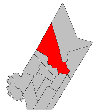
Northesk is a geographic parish in Northumberland County, New Brunswick, Canada.

<span class="mw-page-title-main">Chatham Parish, New Brunswick</span> Parish in New Brunswick, Canada

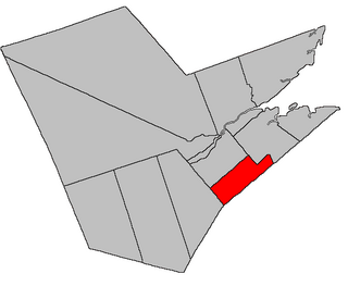
Chatham is a geographic parish in Northumberland County, New Brunswick, Canada.

<span class="mw-page-title-main">Southesk Parish, New Brunswick</span> Parish in New Brunswick, Canada

Southesk is a geographic parish in Northumberland County, New Brunswick, Canada.

<span class="mw-page-title-main">Derby Parish, New Brunswick</span> Parish in New Brunswick, Canada

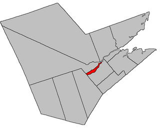
Derby is a geographic parish in Northumberland County, New Brunswick, Canada.

<span class="mw-page-title-main">Nelson Parish, New Brunswick</span> Parish in New Brunswick, Canada

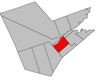
Nelson is a geographic parish in Northumberland County, New Brunswick, Canada.

<span class="mw-page-title-main">Glenelg Parish, New Brunswick</span> Parish in New Brunswick, Canada

Glenelg is a geographic parish in Northumberland County, New Brunswick, Canada.

<span class="mw-page-title-main">Rogersville Parish, New Brunswick</span> Parish in New Brunswick, Canada

Rogersville is a geographic parish in Northumberland County, New Brunswick, Canada.

<span class="mw-page-title-main">Blackville Parish, New Brunswick</span> Parish in New Brunswick, Canada

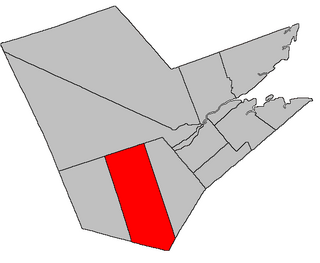
Blackville is a geographic parish in Northumberland County, New Brunswick, Canada.

<span class="mw-page-title-main">Lorne Parish, New Brunswick</span> Parish in New Brunswick, Canada

Lorne is a geographic parish in Victoria County, New Brunswick, Canada.

<span class="mw-page-title-main">Gordon Parish, New Brunswick</span> Parish in New Brunswick, Canada

Gordon is a geographic parish in Victoria County, New Brunswick, Canada.

<span class="mw-page-title-main">Brighton Parish, New Brunswick</span> Parish in New Brunswick, Canada

Brighton is a geographic parish in Carleton County, New Brunswick, Canada, northeast of Woodstock, extending from the eastern bank of the Saint John River to the York County line.

<span class="mw-page-title-main">Douglas Parish, New Brunswick</span> Parish in New Brunswick, Canada

Douglas is a geographic parish in York County, New Brunswick, Canada.

<span class="mw-page-title-main">Stanley Parish, New Brunswick</span> Parish in New Brunswick, Canada

Stanley is a geographic parish in York County, New Brunswick, Canada.

<span class="mw-page-title-main">Saint Patrick Parish, New Brunswick</span> Parish in Canada

Saint Patrick is a geographic parish in Charlotte County, New Brunswick, Canada, located west of St. George and Saint Andrews.

References

  1. 1 2 2011 Statistics Canada Census Profile: Ludlow Parish, New Brunswick
  2. 1 2 3 "Chapter T-3 Territorial Division Act". Government of New Brunswick. Retrieved 13 February 2023.
  3. "Chapter I-13 Interpretation Act". Government of New Brunswick. Retrieved 13 February 2023.
  4. The Territorial Division Act [2] divides the province into 152 parishes, the cities of Saint John and Fredericton, and one town of Grand Falls. The Interpretation Act [3] clarifies that parishes include any local government within their borders.
  5. "Greater Miramichi Regional Service Commission: RSC 5". Government of New Brunswick. Retrieved 13 February 2023.
  6. "Regions Regulation – Regional Service Delivery Act". Government of New Brunswick. 21 July 2022. Retrieved 13 February 2023.
  7. "Regulation 71–26 under the Municipalities Act (O. C. 71–165)". The Royal Gazette. 129. Fredericton: 187. 17 March 1971.
  8. "Regulation 68–64 under the Municipalities Act (O. C. 68–592)". The Royal Gazette. 126. Fredericton: 407–408. 24 July 1968.
  9. "Regulation 68–94 under the Municipalities Act (O. C. 68–849)". The Royal Gazette. 126. Fredericton: 514–521. 2 October 1968.
  10. Ganong, William F. (1906). Additions and Corrections to Monographs on the Place-Nomenclature, Cartography, Historic Sites, Boundaries and Settlement-origins of the Province of New Brunswick. Royal Society of Canada. p. 31. Retrieved 12 April 2021.
  11. "Ludlow Parish". Provincial Archives of New Brunswick. Retrieved 17 April 2021.
  12. "Ludlow, George Duncan". Dictionary of Canadian Biography. Retrieved 22 October 2020.
  13. "Ludlow, Gabriel George". Dictionary of Canadian Biography. Retrieved 22 October 2020.
  14. 1 2 3 4 "54 Geo. III c. 17 An Act in further addition to an Act, intituled 'An Act for the better ascertaining and confirming the boundaries of the several Counties, within this Province, and for subdividing them into Towns or Parishes.'". Acts of the General Assembly of His Majesty's Province of New-Brunswick; Passed in the Year 1814. Saint John, New Brunswick: Government of New Brunswick. 1814. pp. 16–18. Retrieved 27 March 2021.
  15. 1 2 "10 & 11 Geo. IV c. 15 An Act to alter the Boundary Lines of certain Parishes in the County of Northumberland, and to erect two new Parishes in said County.". Acts of the General Assembly of His Majesty's Province of New Brunswick, Passed in the Year 1830. Fredericton: Government of New Brunswick. 1830. pp. 17–18. Retrieved 27 March 2021.
  16. 1 2 3 4 5 "No. 75". Provincial Archives of New Brunswick. Department of Natural Resources and Energy Development. Retrieved 18 June 2021. Remainder of parish on maps 76, 84–86, 95, and 96 at same site.
  17. 1 2 3 4 5 "215" (PDF). Transportation and Infrastructure. Government of New Brunswick. Retrieved 18 June 2021. Remainder of parish on mapbooks 228–230, 244–246, 261–263, 277–279, and 295 at same site.
  18. "Historical Magnetic Declination". National Oceanic and Atmospheric Administration. Retrieved 13 March 2021.
  19. "Chapter 227 Territorial Division Act". The Revised Statutes of New Brunswick 1952 Volume III. Fredericton: Government of New Brunswick. 1952. pp. 3725–3771.
  20. "13 Vic. c. 51 An Act to consolidate all the Laws now in force for the division of the Province into Counties, Towns and Parishes.". Acts of the General Assembly of Her Mjaesty's Province of New Brunswick, Passed in the Year 1850. Fredericton: Government of New Brunswick. 1850. pp. 142–152, 145–149. Retrieved 20 March 2021. Book was poorly proofread, resulting in title typo and reuse of page numbers 145–152.
  21. "Chapter 2 The Division of the Province into Counties, Towns, and Parishes.". The Consolidated Statutes of New Brunswick. Fredericton: Government of New Brunswick. 1877. pp. 56–85. Available as a free ebook from Google Books.
  22. "3 Elizabeth II, 1954, c. 83 An Act to Amend the Territorial Division Act". Acts of the Legislature of New Brunswick Passed During the Session of 1954. Fredericton: Government of New Brunswick. 1954. pp. 189–191. Scans of this Act may be requested from the Legislative Library of New Brunswick.
  23. 1 2 3 4 "Search the Canadian Geographical Names Database (CGNDB)". Government of Canada. Retrieved 7 July 2021.
  24. "Explore New Brunswick's Protected Natural Areas". GeoNB. Retrieved 2 July 2021.
  25. "New Brunswick Regulation 94-43 under the Fish and Wildlife Act (O.C. 94-231)". Government of New Brunswick. 5 June 2006. Retrieved 8 July 2021.
  26. Statistics Canada: 1996, 2001, 2006 census
  27. 2006 Statistics Canada Community Profile: Ludlow Parish, New Brunswick


46°29′24″N66°21′00″W / 46.49000°N 66.35000°W / 46.49000; -66.35000 (Ludlow Parish, New Brunswick)