Marshallville, Ohio

Last updated

Marshallville, Ohio
Marshallville, Ohio Post Office.jpg
Post Office
OHMap-doton-Marshallville.png
Location of Marshallville, Ohio
Map of Wayne County Ohio Highlighting Marshallville Village.png
Location of Marshallville in Wayne County
Coordinates: 40°53′59″N81°43′59″W / 40.89972°N 81.73306°W / 40.89972; -81.73306
Country United States
State Ohio
County Wayne
Area
[1]
  Total0.59 sq mi (1.53 km2)
  Land0.59 sq mi (1.53 km2)
  Water0.00 sq mi (0.00 km2)
Elevation
[2]
1,112 ft (339 m)
Population
 (2020)
  Total789
  Density1,335.03/sq mi (515.40/km2)
Time zone UTC-5 (Eastern (EST))
  Summer (DST) UTC-4 (EDT)
ZIP code
44645
Area code 330
FIPS code 39-48048 [3]
GNIS feature ID2399263 [2]
Website Village website

Marshallville is a village in Wayne County, Ohio. The population was 789 at the time of the 2020 census. Marshallville was originally called Bristol, and under the latter name was laid out in 1817. [4]

Contents

Geography

According to the United States Census Bureau, the village has a total area of 0.57 square miles (1.48 km2), all of it land. [5]

Demographics

Historical population
CensusPop.Note
1870 322
1880 37616.8%
1890 366−2.7%
1900 357−2.5%
1910 294−17.6%
1920 2950.3%
1930 3249.8%
1940 37315.1%
1950 45822.8%
1960 61133.4%
1970 69313.4%
1980 78813.7%
1990 758−3.8%
2000 8269.0%
2010 756−8.5%
2020 7894.4%
U.S. Decennial Census [6]

2010 census

As of the census [7] of 2010, there were 756 people, 291 households, and 222 families living in the village. The population density was 1,326.3 inhabitants per square mile (512.1/km2). There were 311 housing units at an average density of 545.6 per square mile (210.7/km2). The racial makeup of the village was 98.4% White, 0.3% African American, 0.8% Native American, and 0.5% from two or more races. Hispanic or Latino of any race were 0.5% of the population.

There were 291 households, of which 36.8% had children under the age of 18 living with them, 58.4% were married couples living together, 9.3% had a female householder with no husband present, 8.6% had a male householder with no wife present, and 23.7% were non-families. 20.3% of all households were made up of individuals, and 8.9% had someone living alone who was 65 years of age or older. The average household size was 2.60 and the average family size was 2.96.

The median age in the village was 39.3 years. 24.1% of residents were under the age of 18; 8.2% were between the ages of 18 and 24; 26.2% were from 25 to 44; 27.9% were from 45 to 64; and 13.6% were 65 years of age or older. The gender makeup of the village was 49.6% male and 50.4% female.

2000 census

As of the census [3] of 2000, there were 826 people, 302 households, and 233 families living in the village. The population density was 1,471.4 inhabitants per square mile (568.1/km2). There were 310 housing units at an average density of 552.2 per square mile (213.2/km2). The racial makeup of the village was 97.58% White, 0.12% African American, 1.09% Native American, 0.36% from other races, and 0.85% from two or more races. Hispanic or Latino of any race were 1.33% of the population.

There were 302 households, out of which 39.4% had children under the age of 18 living with them, 66.2% were married couples living together, 7.6% had a female householder with no husband present, and 22.8% were non-families. 19.9% of all households were made up of individuals, and 9.6% had someone living alone who was 65 years of age or older. The average household size was 2.74 and the average family size was 3.14.

In the village, the population was spread out, with 29.3% under the age of 18, 6.8% from 18 to 24, 32.0% from 25 to 44, 21.7% from 45 to 64, and 10.3% who were 65 years of age or older. The median age was 35 years. For every 100 females there were 101.0 males. For every 100 females age 18 and over, there were 94.7 males.

The median income for a household in the village was $42,632, and the median income for a family was $44,722. Males had a median income of $31,250 versus $23,125 for females. The per capita income for the village was $14,156. About 3.3% of families and 5.9% of the population were below the poverty line, including 6.1% of those under age 18 and 10.8% of those age 65 or over.

Education

Marshallville students attend Green Local Schools in nearby Smithville.

Marshallville had a three-year high school until 1938 when the State of Ohio told them they could not operate as a three-year school. The building was then closed and students were sent to school in Dalton. After the state discovered they were going across another district (Orrville) to get to school, [8] they merged their old district into Smithville's in 1955. The Marshallville Tigers were one of the original members of the Wayne County Athletic League's "B" League. [9]

Notable people

Related Research Articles

<span class="mw-page-title-main">Wayne County, Ohio</span> County in Ohio, United States

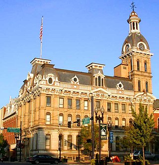
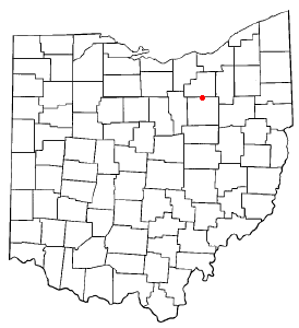
Wayne County is a county in the U.S. state of Ohio. As of the 2020 census, the population was 116,894. Its county seat is Wooster. The county is named for General "Mad" Anthony Wayne. Wayne County comprises the Wooster, OH Micropolitan Statistical Area.

<span class="mw-page-title-main">Smithville, Missouri</span> City in Missouri, United States

Smithville is a city in Clay and Platte counties in the U.S. state of Missouri and is part of the Kansas City metropolitan area, along the Little Platte River. The population was 10,406 at the 2020 United States Census.

<span class="mw-page-title-main">Warsaw, Ohio</span> Village in Ohio, United States

Warsaw is a village in Coshocton County, Ohio, United States, along the Walhonding River. The population was 624 at the 2020 census.

<span class="mw-page-title-main">Versailles, Ohio</span> Village in Ohio, United States

Versailles is a village in Darke County, Ohio, United States. It is the only village in Wayne Township. The population was 2,692 at the 2020 census.

<span class="mw-page-title-main">Wayne Lakes, Ohio</span> Village in Ohio, United States

Wayne Lakes is a village in Darke County, Ohio, United States. The population was 693 at the 2020 census.

<span class="mw-page-title-main">Brice, Ohio</span> Village in Ohio, United States

Brice is a village in Franklin County, Ohio, United States, on the southeast side of the Columbus metropolitan area. The population was 93 at the 2020 census.

<span class="mw-page-title-main">Whitehouse, Ohio</span> Village in Ohio, United States

Whitehouse is a village within the Toledo Metropolitan Area in Lucas County, Ohio, United States. The population was 4,990 at the 2020 census.

<span class="mw-page-title-main">Helena, Ohio</span> Village in Ohio, United States

Helena is a village in Sandusky County, Ohio, United States. The population was 211 at the 2020 census.

<span class="mw-page-title-main">Corwin, Ohio</span> Village in Ohio, United States

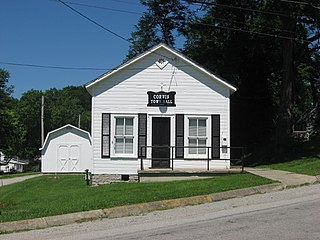
Corwin is a village in Wayne Township, Warren County, Ohio, United States. The population was 484 at the 2020 census.

<span class="mw-page-title-main">Waynesville, Ohio</span> Village in Ohio, United States

Waynesville is a village in Wayne Township, Warren County, Ohio, United States. The population was 2,669 at the 2020 census. It is named for General "Mad" Anthony Wayne. The village, located at the crossroads of U.S. Route 42 and State Route 73, is known for its antique stores and its annual sauerkraut festival. Caesar Creek State Park is located 5 miles (8.0 km) east of the village.

<span class="mw-page-title-main">Burbank, Ohio</span> Village in Ohio, United States

Burbank is a village in Wayne County, Ohio, United States, along Killbuck Creek. The population was 296 at the 2020 census.

<span class="mw-page-title-main">Congress, Ohio</span> Village in Ohio, United States

Congress is a village in Wayne County, Ohio, United States. The population was 132 at the 2020 census.

<span class="mw-page-title-main">Shreve, Ohio</span> Village in Ohio, United States

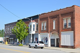
Shreve is a village in Clinton Township, Wayne County, Ohio, United States. The population was 1,497 at the 2020 census. Shreve is served by a branch of the Wayne County Public Library.

<span class="mw-page-title-main">Smithville, Ohio</span> Village in Ohio, United States

Smithville is a village in Wayne County, Ohio, United States. The population was 1,338 at the time of the 2020 census. The village derives its name from Thomas Smith, a pioneer settler.

<span class="mw-page-title-main">West Salem, Ohio</span> Village in Ohio, United States

West Salem is a village in Wayne County, Ohio. The population was 1,430 at the time of the 2020 census. West Salem is served by a branch of the Wayne County Public Library.

<span class="mw-page-title-main">Wayne, Ohio</span> Village in Ohio, United States

Wayne is a village in Wood County, Ohio, United States. The population was 841 at the 2020 census.

<span class="mw-page-title-main">South Wayne, Wisconsin</span> Village in Wisconsin, United States

South Wayne is a village in Lafayette County, Wisconsin, United States. The population was 489 at the 2010 census.

<span class="mw-page-title-main">Gratiot, Ohio</span> Village in Ohio, United States

Gratiot is a village in Licking and Muskingum counties in the U.S. state of Ohio. The population was 215 at the 2020 census.

<span class="mw-page-title-main">Creston, Ohio</span> Village in Ohio, United States

Creston is a village in Medina and Wayne counties in the U.S. state of Ohio. The population was 2,139 at the 2020 census.

<span class="mw-page-title-main">Rittman, Ohio</span> City in Ohio, United States

Rittman is a city in Medina and Wayne counties in the U.S. state of Ohio. All but a small portion of the city is in Wayne County, within commuting distance of Akron, Canton and Cleveland. The population was 6,131 at the 2020 census.

References

  1. "ArcGIS REST Services Directory". United States Census Bureau. Retrieved September 20, 2022.
  2. 1 2 U.S. Geological Survey Geographic Names Information System: Marshallville, Ohio
  3. 1 2 "U.S. Census website". United States Census Bureau . Retrieved January 31, 2008.
  4. Overman, William Daniel (1958). Ohio Town Names. Akron, OH: Atlantic Press. p. 84.
  5. "US Gazetteer files 2010". United States Census Bureau. Archived from the original on July 2, 2012. Retrieved January 6, 2013.
  6. "Census of Population and Housing". Census.gov. Retrieved June 4, 2015.
  7. "U.S. Census website". United States Census Bureau . Retrieved January 6, 2013.
  8. Vasas, Michale Paul (1989). A History of Wayne County Football 1899 to 1988. Collier Printing Company of Wooster, Ohio.
  9. "History of the Wayne County Athletic League". Archived from the original on March 1, 2011. Retrieved June 27, 2012.