West Salem, Ohio

Last updated

West Salem, Ohio
West Salem Ohio City Hall.jpg
City Hall (1899)
OHMap-doton-West Salem.png
Location of West Salem, Ohio
Map of Wayne County Ohio Highlighting West Salem Village.png
Location of West Salem in Wayne County
Coordinates: 40°58′10″N82°06′29″W / 40.96944°N 82.10806°W / 40.96944; -82.10806
Country United States
State Ohio
County Wayne
Area
[1]
  Total1.07 sq mi (2.77 km2)
  Land1.07 sq mi (2.76 km2)
  Water0.00 sq mi (0.01 km2)
Elevation
[2]
1,093 ft (333 m)
Population
 (2020)
  Total1,430
  Density1,340.21/sq mi (517.36/km2)
Time zone UTC-5 (Eastern (EST))
  Summer (DST) UTC-4 (EDT)
ZIP code
44287
Area code 419
FIPS code 39-84196
GNIS feature ID2400143 [2]
Website westsalemvillage.com

West Salem is a village in Wayne County, Ohio. The population was 1,430 at the time of the 2020 census. West Salem is served by a branch of the Wayne County Public Library. [3]

Contents

History

West Salem was laid out in 1834. [4]

Geography

According to the United States Census Bureau, the village has a total area of 1.09 square miles (2.82 km2), all of it land. [5]

Demographics

Historical population
CensusPop.Note
1870 713
1880 87823.1%
1890 756−13.9%
1900 656−13.2%
1910 642−2.1%
1920 636−0.9%
1930 6451.4%
1940 7008.5%
1950 86022.9%
1960 1,01718.3%
1970 1,0584.0%
1980 1,35728.3%
1990 1,53413.0%
2000 1,501−2.2%
2010 1,464−2.5%
2020 1,430−2.3%
U.S. Decennial Census [6]

2010 census

As of the census [7] of 2010, there were 1,464 people, 558 households, and 393 families living in the village. The population density was 1,343.1 inhabitants per square mile (518.6/km2). There were 620 housing units at an average density of 568.8 per square mile (219.6/km2). The racial makeup of the village was 97.8% White, 0.1% African American, 0.1% Native American, 1.0% from other races, and 1.0% from two or more races. Hispanic or Latino of any race were 2.1% of the population.

There were 558 households, of which 38.7% had children under the age of 18 living with them, 48.0% were married couples living together, 14.2% had a female householder with no husband present, 8.2% had a male householder with no wife present, and 29.6% were non-families. 23.7% of all households were made up of individuals, and 7.7% had someone living alone who was 65 years of age or older. The average household size was 2.62 and the average family size was 3.00.

The median age in the village was 37.1 years. 27.1% of residents were under the age of 18; 8% were between the ages of 18 and 24; 27% were from 25 to 44; 27.2% were from 45 to 64; and 10.9% were 65 years of age or older. The gender makeup of the village was 50.6% male and 49.4% female.

2000 census

As of the census [8] of 2000, there were 1,501 people, 573 households, and 389 families living in the village. The population density was 1,453.1 inhabitants per square mile (561.0/km2). There were 620 housing units at an average density of 600.2 per square mile (231.7/km2). The racial makeup of the village was 97.34% White, 0.13% African American, 0.27% Native American, 0.40% Asian, 0.20% Pacific Islander, 0.33% from other races, and 1.33% from two or more races. Hispanic or Latino of any race were 0.93% of the population.

There were 573 households, out of which 39.6% had children under the age of 18 living with them, 51.7% were married couples living together, 12.2% had a female householder with no husband present, and 32.1% were non-families. 27.2% of all households were made up of individuals, and 10.3% had someone living alone who was 65 years of age or older. The average household size was 2.62 and the average family size was 3.19.

In the village, the population was spread out, with 31.0% under the age of 18, 7.5% from 18 to 24, 32.8% from 25 to 44, 19.3% from 45 to 64, and 9.5% who were 65 years of age or older. The median age was 32 years. For every 100 females there were 100.1 males. For every 100 females age 18 and over, there were 96.2 males.

The median income for a household in the village was $36,563, and the median income for a family was $41,250. Males had a median income of $31,393 versus $20,947 for females. The per capita income for the village was $14,309. About 6.4% of families and 7.9% of the population were below the poverty line, including 8.2% of those under age 18 and 11.0% of those age 65 or over.

Notable people

Related Research Articles

<span class="mw-page-title-main">North Salem, Indiana</span> Town in Indiana, United States

North Salem is a town in Eel River Township, Hendricks County, Indiana, United States. The population was 518 at the 2010 Census.

<span class="mw-page-title-main">Athens, Michigan</span> Village in Michigan, United States

Athens is a village in Calhoun County in the U.S. state of Michigan. The population was 936 at the 2020 census. The village is located in southern Athens Township, and is part of the Battle Creek, Michigan Metropolitan Statistical Area. It was settled in 1831.

<span class="mw-page-title-main">Elkton, Michigan</span> Village in Michigan, United States

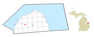
Elkton is a village in Huron County in the U.S. state of Michigan. The population was 796 at the 2020 census. The village is within Oliver Township, along the Pinnebog River. It was incorporated in 1897.

<span class="mw-page-title-main">Salem, Nebraska</span> Village in Richardson County, Nebraska, United States

Salem is a village in Richardson County, Nebraska, United States. The population was 84 at the 2020 census.

<span class="mw-page-title-main">Flushing, Ohio</span> Village in Ohio, United States

Flushing is a village in Belmont County, Ohio, United States. The population was 830 at the 2020 census.

<span class="mw-page-title-main">Wayne Lakes, Ohio</span> Village in Ohio, United States

Wayne Lakes is a village in Darke County, Ohio, United States. The population was 693 at the 2020 census.

<span class="mw-page-title-main">Whitehouse, Ohio</span> Village in Ohio, United States

Whitehouse is a village within the Toledo Metropolitan Area in Lucas County, Ohio, United States. The population was 4,990 at the 2020 census.

<span class="mw-page-title-main">South Salem, Ohio</span> Village in Ohio, United States

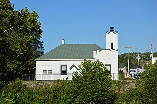
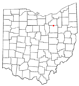
South Salem is a village in Ross County, Ohio, United States. The population was 219 at the 2020 census.

<span class="mw-page-title-main">Morrow, Ohio</span> Village in Ohio, United States

Morrow is a village in Salem Township, Warren County, Ohio, United States. The population was 2,049 at the 2020 census.

<span class="mw-page-title-main">Apple Creek, Ohio</span> Village in Ohio, United States

Apple Creek is a village in East Union Township, Wayne County, Ohio, United States. The population was 1,188 at the 2020 census.

<span class="mw-page-title-main">Burbank, Ohio</span> Village in Ohio, United States

Burbank is a village in Wayne County, Ohio, United States, along Killbuck Creek. The population was 296 at the 2020 census.

<span class="mw-page-title-main">Dalton, Ohio</span> Village in Ohio, United States

Dalton is a village in Wayne County, Ohio, United States. The 2020 census indicated a population of 1,927.

<span class="mw-page-title-main">Shreve, Ohio</span> Village in Ohio, United States

Shreve is a village in Clinton Township, Wayne County, Ohio, United States. The population was 1,497 at the 2020 census. Shreve is served by a branch of the Wayne County Public Library.

<span class="mw-page-title-main">Salem Township, Wayne County, Pennsylvania</span> Township in Pennsylvania, United States

Salem is a second-class township in Wayne County, Pennsylvania, United States. The township's population was 4,271 at the time of the 2010 United States Census.

<span class="mw-page-title-main">Silver Lake, Wisconsin</span> Former village in Wisconsin, United States

Silver Lake is a former village and now a neighborhood within the village of Salem Lakes in Kenosha County, Wisconsin, United States. The population was 2,411 at the 2010 census, when the community was still an independent village. On February 14, 2017, the village merged with the town of Salem to create the village of Salem Lakes.

<span class="mw-page-title-main">West Salem, Wisconsin</span> Village in Wisconsin, United States

West Salem is a village in La Crosse County, Wisconsin, United States, along the La Crosse River. It is part of the La Crosse-Onalaska, WI-MN Metropolitan Statistical Area. The population was 5,277 as of the 2020 census.

<span class="mw-page-title-main">South Wayne, Wisconsin</span> Village in Wisconsin, United States

South Wayne is a village in Lafayette County, Wisconsin, United States. The population was 489 at the 2010 census.

<span class="mw-page-title-main">Washingtonville, Ohio</span> Village in Ohio, United States

Washingtonville is a village in northern Columbiana and southern Mahoning counties in the U.S. state of Ohio. The population was 712 at the 2020 census. Southern Washingtonville is included in the Salem micropolitan area, while northern Washingtonville is part of the Youngstown–Warren metropolitan area.

<span class="mw-page-title-main">Creston, Ohio</span> Village in Ohio, United States

Creston is a village in Medina and Wayne counties in the U.S. state of Ohio. The population was 2,139 at the 2020 census.

<span class="mw-page-title-main">Rittman, Ohio</span> City in Ohio, United States

Rittman is a city in Medina and Wayne counties in the U.S. state of Ohio. All but a small portion of the city is in Wayne County, within commuting distance of Akron, Canton and Cleveland. The population was 6,131 at the 2020 census.

References

  1. "ArcGIS REST Services Directory". United States Census Bureau. Retrieved September 20, 2022.
  2. 1 2 U.S. Geological Survey Geographic Names Information System: West Salem, Ohio
  3. "Hours & Contact Information". Wayne County Public Library. Archived from the original on August 8, 2016. Retrieved June 10, 2016.
  4. Overman, William Daniel (1958). Ohio Town Names. Akron, OH: Atlantic Press. p. 143.
  5. "US Gazetteer files 2010". United States Census Bureau . Retrieved January 6, 2013.
  6. "Census of Population and Housing". Census.gov. Retrieved June 4, 2015.
  7. "U.S. Census website". United States Census Bureau . Retrieved January 6, 2013.
  8. "U.S. Census website". United States Census Bureau . Retrieved January 31, 2008.