Mount Eaton, Ohio

Last updated

Mount Eaton, Ohio
MountEatonOH.jpg
Central Mount Eaton
OHMap-doton-Mount Eaton.png
Location of Mount Eaton, Ohio
Map of Wayne County Ohio Highlighting Mount Eaton Village.png
Location of Mount Eaton in Wayne County
Coordinates: 40°41′41″N81°42′08″W / 40.69472°N 81.70222°W / 40.69472; -81.70222
Country United States
State Ohio
County Wayne
Area
[1]
  Total0.17 sq mi (0.44 km2)
  Land0.17 sq mi (0.44 km2)
  Water0.00 sq mi (0.00 km2)
Elevation
[2]
1,250 ft (380 m)
Population
 (2020)
  Total171
  Density1,005.88/sq mi (388.25/km2)
Time zone UTC-5 (Eastern (EST))
  Summer (DST) UTC-4 (EDT)
ZIP code
44659
Area code 330
FIPS code 39-52682 [3]
GNIS feature ID2399410 [2]

Mount Eaton is a village in Wayne County, Ohio, United States. The population was 171 at the 2020 census.

Contents

History

Mount Eaton was platted in 1814. [4]

Located near Mount Eaton is the historic James Akey Farm, also known as the "Stark Wilderness Center Pioneer Farm"; it is listed on the National Register of Historic Places. [5]

Geography

According to the United States Census Bureau, the village has a total area of 0.18 square miles (0.47 km2), all of it land. [6]

Demographics

Historical population
CensusPop.Note
1870 296
1880 2980.7%
1890 278−6.7%
1900 232−16.5%
1910 208−10.3%
1920 177−14.9%
1930 171−3.4%
1940 20017.0%
1950 2031.5%
1960 26530.5%
1970 242−8.7%
1980 28919.4%
1990 236−18.3%
2000 2464.2%
2010 241−2.0%
2020 171−29.0%
U.S. Decennial Census [7]

85.0% spoke English, 10.0% Dutch, and 5.0% Pennsylvania Dutch as their first language. [8]

2010 census

As of the census [9] of 2010, there were 241 people, 93 households, and 62 families living in the village. The population density was 1,338.9 inhabitants per square mile (517.0/km2). There were 103 housing units at an average density of 572.2 per square mile (220.9/km2). The racial makeup of the village was 98.8% White, 0.4% from other races, and 0.8% from two or more races. Hispanic or Latino of any race were 0.4% of the population.

There were 93 households, of which 29.0% had children under the age of 18 living with them, 53.8% were married couples living together, 7.5% had a female householder with no husband present, 5.4% had a male householder with no wife present, and 33.3% were non-families. 28.0% of all households were made up of individuals, and 9.7% had someone living alone who was 65 years of age or older. The average household size was 2.59 and the average family size was 3.26.

The median age in the village was 36.5 years. 24.9% of residents were under the age of 18; 10.3% were between the ages of 18 and 24; 24.4% were from 25 to 44; 27.8% were from 45 to 64; and 12.4% were 65 years of age or older. The gender makeup of the village was 48.1% male and 51.9% female.

2000 census

As of the census [3] of 2000, there were 246 people, 89 households, and 60 families living in the village. The population density was 1,502.5 inhabitants per square mile (580.1/km2). There were 99 housing units at an average density of 604.7 per square mile (233.5/km2). The racial makeup of the village was 99.19% White, 0.41% African American, 0.41% Native American and 1.00% Pacific Islander.

There were 89 households, out of which 36.0% had children under the age of 18 living with them, 61.8% were married couples living together, 4.5% had a female householder with no husband present, and 31.5% were non-families. 28.1% of all households were made up of individuals, and 10.1% had someone living alone who was 65 years of age or older. The average household size was 2.76 and the average family size was 3.46.

In the village, the population was spread out, with 28.9% under the age of 18, 12.2% from 18 to 24, 26.8% from 25 to 44, 21.5% from 45 to 64, and 10.6% who were 65 years of age or older. The median age was 32 years. For every 100 females there were 98.4 males. For every 100 females age 18 and over, there were 103.5 males.

The median income for a household in the village was $45,357, and the median income for a family was $46,827. Males had a median income of $32,188 versus $23,333 for females. The per capita income for the village was $16,939. None of the families and 0.4% of the population were living below the poverty line.

Related Research Articles

<span class="mw-page-title-main">Eaton, Indiana</span> Town in Indiana, United States

Eaton is a town in Union Township, Delaware County, Indiana, along the Mississinewa River. The population was 1,595 at the 2020 census. It is part of the Muncie Metropolitan Statistical Area.

<span class="mw-page-title-main">Mulliken, Michigan</span> Village in Michigan, United States

Mulliken is a village in Eaton County in the U.S. state of Michigan. The population was 553 at the 2010 census. The village is within Roxand Township.

<span class="mw-page-title-main">Sunfield, Michigan</span> Village in Michigan, United States

Sunfield is a village in Eaton County in the U.S. state of Michigan. The population was 518 at the 2020 U.S. Census. The village is located within Sunfield Township.

<span class="mw-page-title-main">Watson, Missouri</span> Village in Missouri

Watson is a village in Nishnabotna Township, Atchison County, Missouri, United States. The population was 61 at the 2020 census. It is the westernmost settlement in the state of Missouri, about 120 miles northwest of Kansas City.

<span class="mw-page-title-main">Foster, Missouri</span> Village in Missouri, United States

Foster is a village in Bates County, Missouri, and part of the Kansas City metropolitan area within the United States. The population was 76 at the 2020 census.

<span class="mw-page-title-main">Rushville, Missouri</span> Village in Missouri, United States

Rushville is a village in western Buchanan County, Missouri, United States. The population was 225 at the 2020 census. It is part of the St. Joseph, MO–KS Metropolitan Statistical Area.

<span class="mw-page-title-main">Gunn City, Missouri</span> Village in Missouri, United States

Gunn City is a village in Cass County, Missouri, United States. The population was 118 at the 2010 census. It is part of the Kansas City metropolitan area.

<span class="mw-page-title-main">West Line, Missouri</span> Village in Missouri, United States

West Line is a village in Cass County, Missouri. The population was 97 at the 2010 census. It is part of the Kansas City metropolitan area.

<span class="mw-page-title-main">Arcola, Missouri</span> Village in Missouri, United States

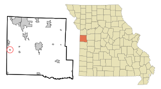
Arcola is a village in Dade County, Missouri, United States. The population was 37 at the 2020 census.

<span class="mw-page-title-main">Aullville, Missouri</span> Village in Missouri, United States

Aullville is a village in Lafayette County, Missouri, and is part of the Kansas City metropolitan area within the United States. The population was 77 at the 2020 census.

<span class="mw-page-title-main">Mooresville, Missouri</span> Village in Missouri, United States

Mooresville is a village in western Livingston County, Missouri, United States. The population was 98 at the 2020 census.

<span class="mw-page-title-main">Utica, Missouri</span> Village in Missouri, United States

Utica is a village in Livingston County, Missouri, United States. The population was 222 at the 2020 census.

<span class="mw-page-title-main">Clyde, Missouri</span> Village in Missouri, United States

Clyde is a village in eastern Nodaway County, Missouri, United States. The population was 82 at the 2010 census.

<span class="mw-page-title-main">Arbela, Missouri</span> Village in Missouri, United States

Arbela is a village in Scotland County, Missouri, United States. As of the 2020 census, its population was 24.

<span class="mw-page-title-main">Josephville, Missouri</span> Village in Missouri, United States

Josephville is a village in St. Charles County, Missouri, United States. The population was 376 at the 2010 census. It is located about 35 miles west of St. Louis.

<span class="mw-page-title-main">Collins, Missouri</span> Village in Missouri, United States

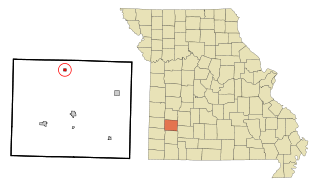
Collins is a village in St. Clair County, Missouri, United States. The population was 125 at the 2020 census.

<span class="mw-page-title-main">Harwood, Missouri</span> Village in Missouri, United States

Harwood is a village in northeast Vernon County, Missouri, United States. The population was 47 at the 2010 census. It was estimated to be 45 by the City of Harwood as of July 1, 2019.

<span class="mw-page-title-main">Eaton, New Hampshire</span> Town in New Hampshire, United States

Eaton is a town in Carroll County, New Hampshire, United States. The population was 405 at the 2020 census. Eaton includes the villages of Eaton Center and Snowville.

<span class="mw-page-title-main">Castine, Ohio</span> Village in Ohio, United States

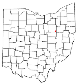
Castine is a village in Darke County, Ohio, United States. The population was 110 at the 2020 census.

<span class="mw-page-title-main">Eaton Estates, Ohio</span> Census-designated place in Ohio, United States

Eaton Estates is an unincorporated community and census-designated place (CDP) in Lorain County, Ohio, United States. The population was 1,155 at the 2020 census.

References

  1. "ArcGIS REST Services Directory". United States Census Bureau. Retrieved September 20, 2022.
  2. 1 2 U.S. Geological Survey Geographic Names Information System: Mount Eaton, Ohio
  3. 1 2 "U.S. Census website". United States Census Bureau . Retrieved January 31, 2008.
  4. Overman, William Daniel (1958). Ohio Town Names. Akron, OH: Atlantic Press. p. 92.
  5. "National Register Information System". National Register of Historic Places . National Park Service. March 13, 2009.
  6. "US Gazetteer files 2010". United States Census Bureau. Archived from the original on July 2, 2012. Retrieved January 6, 2013.
  7. "Census of Population and Housing". Census.gov. Retrieved June 4, 2015.
  8. "Data Center Results". Archived from the original on August 15, 2013. Retrieved August 15, 2013.
  9. "U.S. Census website". United States Census Bureau . Retrieved January 6, 2013.