Maurice, Iowa

Last updated
Maurice, Iowa
Sioux County Iowa Incorporated and Unincorporated areas Maurice Highlighted.svg
Location of Maurice, Iowa
Coordinates: 42°57′58″N96°10′51″W / 42.96611°N 96.18083°W / 42.96611; -96.18083 Coordinates: 42°57′58″N96°10′51″W / 42.96611°N 96.18083°W / 42.96611; -96.18083
Country Flag of the United States.svg  United States
State Flag of Iowa.svg  Iowa
County Sioux
Area
[1]
  Total0.61 sq mi (1.57 km2)
  Land0.60 sq mi (1.56 km2)
  Water0.01 sq mi (0.01 km2)
Elevation
1,319 ft (402 m)
Population
 (2020)
  Total265
  Density440.20/sq mi (170.01/km2)
Time zone UTC-6 (Central (CST))
  Summer (DST) UTC-5 (CDT)
ZIP code
51036
Area code 712
FIPS code 19-50430
GNIS feature ID0458859

Maurice is a city in Sioux County, Iowa, United States, along the West Branch of the Floyd River. The population was 265 at the time of the 2020 census. [2] It is home to the "Famous Maurice Fire Escape Slide" in the town park.

Contents

History

Maurice was platted in 1882. [3] It was named for Maurice, Prince of Orange. [3] A post office has been in operation in Maurice since 1882. [4]

Geography

Maurice is located at 42°57′58″N96°10′51″W / 42.96611°N 96.18083°W / 42.96611; -96.18083 (42.966226, -96.180848). [5]

According to the United States Census Bureau, the city has a total area of 0.56 square miles (1.45 km2), of which 0.55 square miles (1.42 km2) is land and 0.01 square miles (0.03 km2) is water. [6]

Demographics

Historical populations
YearPop.±%
1900 280    
1910 290+3.6%
1920 329+13.4%
1930 274−16.7%
1940 272−0.7%
1950 256−5.9%
1960 237−7.4%
1970 266+12.2%
1980 288+8.3%
1990 243−15.6%
2000 254+4.5%
2010 275+8.3%
2020 265−3.6%
Source: "U.S. Census website". United States Census Bureau . Retrieved 2020-03-29. and Iowa Data Center
Source:
U.S. Decennial Census [7] [2]

2010 census

As of the census [8] of 2010, there were 275 people, 102 households, and 81 families residing in the city. The population density was 500.0 inhabitants per square mile (193.1/km2). There were 107 housing units at an average density of 194.5 per square mile (75.1/km2). The racial makeup of the city was 95.6% White, 0.4% African American, 3.3% from other races, and 0.7% from two or more races. Hispanic or Latino of any race were 5.8% of the population.

There were 102 households, of which 34.3% had children under the age of 18 living with them, 72.5% were married couples living together, 4.9% had a female householder with no husband present, 2.0% had a male householder with no wife present, and 20.6% were non-families. 15.7% of all households were made up of individuals, and 6.9% had someone living alone who was 65 years of age or older. The average household size was 2.70 and the average family size was 3.02.

The median age in the city was 34.6 years. 25.8% of residents were under the age of 18; 10.5% were between the ages of 18 and 24; 23.8% were from 25 to 44; 25.4% were from 45 to 64; and 14.5% were 65 years of age or older. The gender makeup of the city was 52.0% male and 48.0% female.

2000 census

As of the census [9] of 2000, there were 254 people, 95 households, and 76 families residing in the city. The population density was 471.0 inhabitants per square mile (181.9/km2). There were 103 housing units at an average density of 191.0 per square mile (73.7/km2). The racial makeup of the city was 100.00% White.

There were 95 households, out of which 32.6% had children under the age of 18 living with them, 77.9% were married couples living together, and 20.0% were non-families. 17.9% of all households were made up of individuals, and 10.5% had someone living alone who was 65 years of age or older. The average household size was 2.67 and the average family size was 3.05.

In the city, the population was spread out, with 26.0% under the age of 18, 8.7% from 18 to 24, 24.4% from 25 to 44, 23.2% from 45 to 64, and 17.7% who were 65 years of age or older. The median age was 39 years. For every 100 females, there were 113.4 males. For every 100 females age 18 and over, there were 116.1 males.

The median income for a household in the city was $41,591, and the median income for a family was $41,705. Males had a median income of $30,347 versus $21,250 for females. The per capita income for the city was $15,455. None of the population or families were below the poverty line.

Education

MOC-Floyd Valley Community School District is the local school district. [10] The district formed on July 1, 1994 with the merger of the Maurice-Orange City and Floyd Valley districts. [11]

Related Research Articles

<span class="mw-page-title-main">Mesquite Creek, Arizona</span> CDP in Mohave County, Arizona

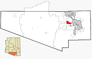
Mesquite Creek is an unincorporated community and census-designated place (CDP) in Mohave County, Arizona, United States. The population was 403 at the 2020 census.

<span class="mw-page-title-main">Tucson Estates, Arizona</span> CDP in Arizona, United States

Tucson Estates is a census-designated place (CDP) in Pima County, Arizona, United States. The population was 9,755 at the 2000 census.

<span class="mw-page-title-main">Grayson, California</span> Census-designated place in California, United States

Grayson is a census-designated place (CDP) in Stanislaus County, California, United States. The population was 952 at the 2010 census, down from 1,077 at the 2000 census. It is part of the Modesto Metropolitan Statistical Area.

<span class="mw-page-title-main">Crystal Springs, Florida</span> CDP in Florida, United States

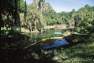
Crystal Springs is a hydrological spring and a census-designated place (CDP) in Pasco County, Florida, United States. The population was 1,175 at the 2000 census.

<span class="mw-page-title-main">Olmsted, Illinois</span> Village in Illinois, United States

Olmsted is a village in Pulaski County, Illinois, along the Ohio River. The population was 299 at the 2000 census.

<span class="mw-page-title-main">Rowley, Iowa</span> City in Iowa, United States

Rowley is a city in Buchanan County, Iowa, United States. The population was 270 at the time of the 2020 census.

<span class="mw-page-title-main">Floyd, Iowa</span> City in Iowa, United States

Floyd is a city in Floyd County, Iowa, United States. The population was 313 at the time of the 2020 census.

<span class="mw-page-title-main">Marble Rock, Iowa</span> City in Iowa, United States

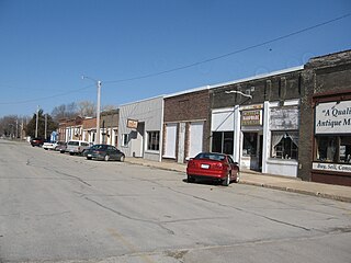
Marble Rock is a city in Floyd County, Iowa, United States, along the Shell Rock River. The population was 271 at the time of the 2020 census. Marble Rock has a city park, historical museums, a powerhouse on the river, and a veterans' memorial. The Marble Rock Historical Society has a website with information about the museums.

<span class="mw-page-title-main">Merrill, Iowa</span> City in Iowa, United States

Merrill is a city in Plymouth County, Iowa, United States, along the Floyd River. The population was 717 at the time of the 2020 census.

<span class="mw-page-title-main">Alton, Iowa</span> City in Iowa, United States

Alton is a city in Sioux County, Iowa, United States, along the Floyd River. The population was 1,248 at the 2020 census.

<span class="mw-page-title-main">Granville, Iowa</span> City in Iowa, United States

Granville is a city in Sioux County, Iowa, United States. The population was 310 at the time of the 2020 census.

<span class="mw-page-title-main">Ryland Heights, Kentucky</span> City in Kentucky, United States

Ryland Heights is a home rule-class city in Kenton County, Kentucky, in the United States. The population was 1,022 at the 2010 census, up from 799 at the 2000 census. It is part of the Cincinnati metropolitan area.

Starks is a town in Somerset County, Maine, United States. The town was named after General John Stark of the Revolutionary War. The population was 593 at the 2020 census.

<span class="mw-page-title-main">Port Huron Township, Michigan</span> Charter township in Michigan, United States

Port Huron Charter Township is a charter township of St. Clair County in the U.S. state of Michigan. The population was 10,654 at the 2010 Census. The city of Port Huron is adjacent to the township.

<span class="mw-page-title-main">Kevin, Montana</span> Town in Montana, United States

Kevin is a town in Toole County, Montana, United States. The population was 154 at the 2020 census, equal to the 2010 Census population. The town was named after Thomas Kevin, superintendent of the Alberta Railway & Irrigation Company. Locals pronounce Kevin with a long E.

Smithfield is a town in Madison County, New York, United States. Administrative offices are in the hamlet of Peterboro. The town and hamlet both are named after Peter Smith, an original land owner. As of the 2010 Census, the population was 1,288.

<span class="mw-page-title-main">Fairdale, North Dakota</span> City in North Dakota, United States

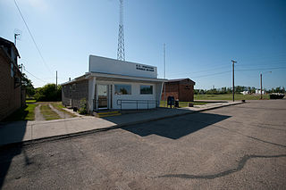
Fairdale is a city in Walsh County, North Dakota, United States. The population was 30 at the 2020 census. Fairdale was founded in 1905.

<span class="mw-page-title-main">Oceanside, Oregon</span> Unincorporated community in the state of Oregon, United States

Oceanside is a census-designated place (CDP) and unincorporated community in Tillamook County, Oregon, United States. The population was 361 at the 2010 census. Oregon Route 131's northern terminus is in the community, which is just north of Netarts. Symons State Park is in Oceanside, while Three Arch Rocks National Wildlife Refuge lies just offshore.

<span class="mw-page-title-main">Wentworth, South Dakota</span> Village in South Dakota, United States

Wentworth is an incorporated village in Lake County, South Dakota, United States. It is the only incorporated village in the state of South Dakota. The population was 181 at the 2020 census.

<span class="mw-page-title-main">Archdale, North Carolina</span> City in North Carolina, United States

Archdale is a city in Guilford and Randolph counties in the U.S. state of North Carolina. It is 15 miles southwest of Greensboro. The population was 11,415 at the 2010 census, up from 9,014 in 2000.

References

  1. "2020 U.S. Gazetteer Files". United States Census Bureau. Retrieved March 16, 2022.
  2. 1 2 "2020 Census State Redistricting Data". census.gov. United states Census Bureau. Retrieved 12 August 2021.
  3. 1 2 Chicago and North Western Railway Company (1908). A History of the Origin of the Place Names Connected with the Chicago & North Western and Chicago, St. Paul, Minneapolis & Omaha Railways. p. 100.
  4. "Sioux County". Jim Forte Postal History. Retrieved 22 March 2015.
  5. "US Gazetteer files: 2010, 2000, and 1990". United States Census Bureau. 2011-02-12. Retrieved 2011-04-23.
  6. "US Gazetteer files 2010". United States Census Bureau. Archived from the original on 2012-01-25. Retrieved 2012-05-11.
  7. "Census of Population and Housing". Census.gov. Retrieved June 4, 2015.
  8. "U.S. Census website". United States Census Bureau . Retrieved 2012-05-11.
  9. "U.S. Census website". United States Census Bureau . Retrieved 2008-01-31.
  10. "MOC-Floyd Valley" (PDF). Iowa Department of Education . Retrieved 2020-03-27.
  11. "REORGANIZATION & DISSOLUTION ACTIONS SINCE 1965-66" (PDF). Iowa Department of Education. Archived from the original (PDF) on 2019-02-09. Retrieved 2020-03-22.