Michigan left

Last updated

Standard design on a wide median Median U-turn crossover on wide median.gif
Standard design on a wide median
Stylized depiction of the design in Grand Haven, Michigan, at US 31 and Robbins Road (north to the right), showing the additional area necessary to make a turn on a narrow median
.mw-parser-output .geo-default,.mw-parser-output .geo-dms,.mw-parser-output .geo-dec{display:inline}.mw-parser-output .geo-nondefault,.mw-parser-output .geo-multi-punct,.mw-parser-output .geo-inline-hidden{display:none}.mw-parser-output .longitude,.mw-parser-output .latitude{white-space:nowrap}
43deg2'40.18''N 86deg13'12.57''W / 43.0444944degN 86.2201583degW / 43.0444944; -86.2201583 (US 31 at Robbins Road, Grand Haven, Michigan) Michigan Left.svg
Stylized depiction of the design in Grand Haven, Michigan, at US 31 and Robbins Road (north to the right), showing the additional area necessary to make a turn on a narrow median 43°2′40.18″N86°13′12.57″W / 43.0444944°N 86.2201583°W / 43.0444944; -86.2201583 (US 31 at Robbins Road, Grand Haven, Michigan)

A Michigan left or P-turn is an at-grade intersection design that replaces each left (farside) turn at an intersection between a (major) divided roadway and a secondary (minor) roadway with the combination of a right (nearside) turn followed by a U-turn, or a U-turn followed by a right (nearside) turn, depending on the situation. It is in use in numerous countries.

Contents

Terminology

This intersection design was given the name "Michigan left" due to its frequent use along roads and highways in the U.S. state of Michigan since the late 1960s. [2] In other contexts, the intersection is called a median Uturn crossover or median Uturn, or restricted crossing U-turn (RCUT). [1] [3] [4] The design is also sometimes referred to as a boulevard left, [5] a boulevard turnaround, [6] an indirect left turn, [2] [7] a Michigan loon, [8] a Jturn, [9] Pturn or a "ThrU Turn" intersection. [10] [11]

Description

Two versions of signs posted along an intersecting road or street at an intersection.
Top: most commonly used; state of Michigan standard.
Bottom: lesser-used variant. MichiganLeftSigns.png
Two versions of signs posted along an intersecting road or street at an intersection.
Top: most commonly used; state of Michigan standard.
Bottom: lesser-used variant.

The design occurs at intersections where at least one road is a divided highway or boulevard, and left turns onto—and usually from—the divided highway are prohibited. In almost every case, the divided highway is multi-laned in both directions. When on the secondary road, drivers are directed to turn right. Within 14 mile (400 m), they queue into a designated U-turn (or cross-over) lane in the median. When traffic clears they complete the U-turn and go back through the intersection. Additionally, the U-turn lane is designed for one-way traffic.

Similarly, traffic on the divided highway cannot turn left at an intersection with a cross street. Instead, drivers are instructed to "overshoot" the intersection, go through the U-turn lane, come back to the intersection from the opposite direction, and turn right.

When vehicles enter the cross-over area, unless markings on the ground indicate two turning lanes in the cross-over, drivers form one lane. A cross-over with two lanes is designed at high-volume cross-overs, or when the right lane turns onto an intersecting street. In this case, the right lane is reserved for vehicles completing the design. Most crossovers must be made large enough for semi-trailer trucks to complete the crossover. This large cross-over area often leads to two vehicles incorrectly lining up at a single cross-over.

A Michigan left generally allows through traffic on the minor crossroads to proceed straight across the major road or highway, especially on the more heavily traveled minor roads.

Its design also is promoted as part of the Federal Highway Administration's Every Day Counts initiative which started in 2011. [13]

Variations

Narrow median

When the median of a road is too narrow to allow for a standard Michigan left maneuver, a variation can be used that widens the pavement in the opposite direction of travel. This widened pavement is known as a "bulb out" [10] or a "loon" (from the pavement's aerial resemblance to the aquatic bird). [8] Such a design is sometimes referred to as a Michigan loon; in Utah, as a thrU turn, where one passes through the intersection before a U-turn. [10]

Grade separation

In Guadalajara, Mexico, there is a grade-separated variation of this setup at the intersection of Mariano Otero Avenue and Manuel Gómez Morín Beltway ( 20°37′50″N103°26′06″W / 20.630666°N 103.434981°W / 20.630666; -103.434981 ). [14] Traffic flowing through Mariano Otero Avenue is routed onto an overpass above the beltway, with two access roads allowing right turns in all four possible directions; the U-turns, meanwhile, are built underneath the beltway and allow the left turn movements from Mariano Otero Avenue to the beltway.

Superstreet

A variation of the Michigan left that prohibits through traffic on minor roads from crossing the major road or highway, is most commonly called a superstreet or a "restricted crossing Uturn" (RCUT). [15] In contrast to the standard Michigan left, left turns from the major road or highway to minor roads are usually allowed, although there is a variation that prohibits such turns.

Examples

Angola

The capital city of Angola, Luanda, makes widespread use of a simplified variant of this type of intersection on its two- and three-lane, median-separated throughways instead of using traffic lights. Larger junctions use this intersection type instead of much more costly grade-separated interchanges.

Australia

In Australia, where traffic drives on the left, the Victorian state government in 2009 introduced the "P-turn", similar to the Michigan left, at the intersection of Moorooduc Highway (C777) and Cranbourne-Frankston Road (State Route 4) in the southeastern Melbourne suburb of Frankston. This requires right-turning vehicles to turn left then make a U-turn. As of May 2015, local residents had called for its removal. [16] [17]

On April 16, 2018, a P-turn was introduced at the intersection of Hoddle Street (State Route 29) and Johnston Street (State Route 34) in Abbotsford, Victoria. Another P-turn was added in 2019 at the intersection of the Punt Road section of State Route 29 and Swan Street (State Route 20) in Richmond. [18]

Brazil

The Michigan left is a commonly used design in Brazil especially in São Paulo and Paraná.

Canada

In Ottawa, Ontario, a Michigan left exists to proceed from Bank Street to Riverside Drive in both directions.

The design has been proposed in Toronto, Ontario, to relieve motorists who wish to make a left-turn on roadways that will contain a proposed streetcar line by the Transit City project.

A Michigan left exists in Windsor, Ontario, on Huron Church Road, just north of the E.C. Row Expressway, where a narrow-median variant put in place years ago is now seldom used due to the realignment of the expressway in conjunction with the construction of the Herb Gray Parkway.

In Saskatoon, Saskatchewan, a Michigan left pairing exists on 8th Street, just west of its interchange with Circle Drive, as well as a few other U-turn lanes as one heads westbound.

Hong Kong

This is the design at some busy junctions in Hong Kong. In Hong Kong Island examples include the junction of Fleming Road and Harbour Road in Wan Chai North, and the junction of Hennessey Road and Canal Road Flyover in Wong Nai Chung. In Kowloon this design exists between Cheong Wan Road and Hong Chong Road/Salisbury Road.

Philippines

A no left-turn scheme at the intersection of Bonny Serrano Avenue and Katipunan Avenue (part of Circumferential Road 5) in Quezon City, Metro Manila 03333jfBarangay Bayanihan Boni Serrano Katipuan Avenue Quezon Cityfvf 22.jpg
A no left-turn scheme at the intersection of Bonny Serrano Avenue and Katipunan Avenue (part of Circumferential Road 5) in Quezon City, Metro Manila

In the Philippines, the Metropolitan Manila Development Authority (MMDA) under Bayani Fernando implemented a "no left-turn" scheme in the early 2000s along several major roads in Metro Manila, prohibiting motor vehicle traffic from turning left at intersections and instead requiring them to make a U-turn at designated U-turn slots and making a right turn after. The scheme was designed to mimic the Michigan left turn design by creating continuous traffic, mitigating bottlenecks caused by traffic light signals. [19] The MMDA claimed that its "no left-turn" scheme in addition to its No Contact Apprehension Policy and road obstruction clearing campaign has increased the average travel speed along major thoroughfares from 14.5 km/h (9.0 mph) in July 2001 to 17.37 km/h (10.79 mph) in June 2003. [20]

However, the implementation of the "no left-turn" scheme in Metro Manila was controversial, as it was notorious among motorists for causing longer travel distances due to having to navigate to the nearest U-turn slot and for incidents of motorists missing their U-turn slot due to difficulties navigating to it safely. Several academic studies were also made on the "no left-turn" scheme, summarizing that the scheme induces longer travel time and only works with low car inflow and minimal lane changing maneuvers, with the U-turn slots eventually becoming congested themselves. [19] [21] Since then, many of these U-turn slots were closed and left-turning at most intersections was restored, although some still remain along roads such as EDSA, Quezon Avenue, and Circumferential Road 5.

Mexico

U-turn intersections are very common throughout Mexico, particularly in Mexico City.

United Kingdom

A similar style P-turn is used in the junction of the A4 Great West Road and A3002 Boston Manor Road in Brentford, England.

United States

In 2013, Michigan lefts were installed in Alabama for the first time, in several locations along heavily traveled U.S. Route 280 in metro Birmingham. [22]

Tucson, Arizona, began introducing Michigan lefts in 2013, at Ina/Oracle and on Grant Road. Their reception has been mixed. [23]

Indianapolis, Indiana, introduced the Michigan Left in 2013 at the intersection of 96th Street, and Allisonville Road (near the surrounding cities of Fishers, Indiana). The city has announced plans to tear out the Michigan Left due to its unpopularity amongst the locals [24]

In November 2018, the Ada County Highway District completed work on a ThrU-turn intersection at the State Street/Veterans Memorial Parkway/36th Street intersection in Boise, Idaho. [25]

The design is relatively common in New Orleans, Louisiana, and its suburb Metairie, where city boulevards may be split by streetcar tracks, [26] and suburban thoroughfares are often split by drainage canals. [27] Some intersections using this design are signed similarly to those in Michigan, but with more descriptive text; [28] however, in some cases the only signage is "No Left Turn" and drivers are left to figure it out for themselves. [29]

Since the redevelopment of the intersection between University Boulevard (MD 193) and Colesville Road (US 29) in Silver Spring, Maryland, a Michigan left has been used to increase efficiency of traffic through an otherwise underdeveloped and congested intersection. Due to its proximity to the Capital Beltway, heavy traffic is handled more safely and efficiently.[ citation needed ]

The Michigan Department of Transportation first used the modern design at the intersection of 8 Mile Road (M-102) and Livernois Avenue [30] ( 42°26′46″N83°08′28″W / 42.4461°N 83.141°W / 42.4461; -83.141 (M-102 (8 Mile Road) at Livernois Avenue) ) [31] in Detroit in the early 1960s. The increase in traffic flow and reduction in accidents was so dramatic (a 30–60% decrease [32] ) that over 700 similar intersections have been deployed throughout the state since then. [33] Michigan keeps building Michigan lefts where the opportunity presents itself, completing a rebuild of a dangerous stretch of highway (US 131 in Three Rivers in 2021). [34]

North Carolina has been implementing Michigan lefts along US 17 in the southeastern part of the state, outside Wilmington. [33] In 2015, a Michigan left was constructed at the intersection of Poplar Tent Road and Derita Road in the Charlotte suburb of Concord.[ citation needed ]

Columbus, Ohio introduced a Michigan left at the intersection of SR 161 and Strawberry Farms Boulevard in 2012.

At least two Michigan lefts have existed in Texas. One was located at the intersection of Fondren Road and Bellaire Boulevard in Houston from the 1980s through 2007, when it was replaced with conventional left-turn lanes. Another was built in mid-2010 in Plano at the intersection of Preston Road and Legacy Drive. [35] In January 2014, the city announced plans to revert the turn to a traditional intersection as a result of drivers' confusion.[ citation needed ] A section of State Highway 71 east of Austin-Bergstrom International Airport at FM 973 in Austin, Texas did have a signalized Michigan U-turn that was constructed in 2014—this was a temporary fix until the SH71 tollway over SH130 (including the re-routing of FM973) was completed in early 2016.[ citation needed ] There are multiple Michigan left turns currently being used along US 281 north of Loop 1604 in San Antonio. These were adopted as a short-term solution for traffic issues as development expanded north, but will likely be phased out as US 281 is elevated.[ citation needed ]

The city of Draper, Utah, a suburb of Salt Lake City, announced in 2011 that it would be building Utah's first "ThrU Turn" at the intersection of 12300 South and State Street, just off Interstate 15 through Salt Lake County. Construction began in summer 2011 and was completed in fall 2011. [10] [36] [37] Other similar intersections were implemented in South Jordan [38] and Layton. [39]

Applicable traffic studies

This type of intersection configuration, as with any engineered solution to a traffic problem, carries with it certain advantages and disadvantages and has been subject to several studies.

Studies have shown a major reduction in left-turn collisions and a minor reduction in merging and diverging collisions, due to the shifting of left turns outside the main intersection. In addition, it reduces the number of different traffic light phases, significantly increasing traffic flow. Because separate phases are no longer needed for left turns, this increases green time for through traffic. The effect on turning traffic is mixed. Consequently, the timing of traffic signals along a highway featuring the design is made easier by the elimination of left-turn phases both on that highway and along intersecting roadways contributing to the reduction of travel times and the increased capacity of those roadways. [1]

It has been shown to enhance safety for pedestrians at these intersections, since they only encounter through traffic and vehicles making right turns. The elimination of left turns removes one source of potential vehicle-pedestrian conflict. [1] One minor disadvantage of the Michigan left is the extra distance required for the motorist to drive. Sometimes the distance to the turnaround is as far away as 14 mile (400 m) past the intersection. This design leads to each motorist driving an additional 12 mile (800 m) to make a left turn. It also results in left-turning vehicles having to stop up to three times in the execution of the turn.

See also

Related Research Articles

<span class="mw-page-title-main">Frontage road</span> Type of road

A frontage road is a local road running parallel to a higher-speed, limited-access road. A frontage road is often used to provide access to private driveways, shops, houses, industries or farms. Where parallel high-speed roads are provided as part of a major highway, these are also known as local lanes. Sometimes a similar arrangement is used for city roads; for example, the collector portion of Commonwealth Avenue in Boston, Massachusetts, is known as a carriage road.

<span class="mw-page-title-main">M-3 (Michigan highway)</span> State highway in Michigan, United States

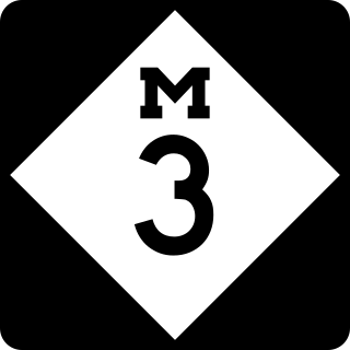
M-3, known for most of its length as Gratiot Avenue, is a north–south state trunkline highway in the Detroit metropolitan area of the US state of Michigan. The trunkline starts in Downtown Detroit and runs through the city in a northeasterly direction along one of Detroit's five major avenues. The highway passes several historic landmarks and through a historic district. It also connects residential neighborhoods on the city's east side with suburbs in Macomb County and downtown.

<span class="mw-page-title-main">Interstate 695 (Maryland)</span> Highway in Maryland

Interstate 695 (I-695) is a 51.46-mile-long (82.82 km) auxiliary Interstate Highway that is a full beltway extending around Baltimore, Maryland, United States. I-695 is officially designated the McKeldin Beltway but is colloquially referred to as either the Baltimore Beltway or 695. The route is an auxiliary route of I-95, intersecting that route southwest of Baltimore near Arbutus and northeast of the city near White Marsh. It also intersects other major roads radiating from the Baltimore area, including I-97 near Glen Burnie, the Baltimore–Washington Parkway near Linthicum, I-70 near Woodlawn, I-795 near Pikesville, and I-83 in the Timonium area. The 19.37-mile (31.17 km) portion of the Baltimore Beltway between I-95 northeast of Baltimore and I-97 south of Baltimore is officially Maryland Route 695 (MD 695) and is not part of the Interstate Highway System but is signed as I-695. This section of the route includes the Francis Scott Key Bridge that crosses over the Patapsco River. The bridge and its approaches are maintained by the Maryland Transportation Authority (MDTA) while the remainder of the Baltimore Beltway is maintained by the Maryland State Highway Administration (MDSHA).

<span class="mw-page-title-main">Superstreet</span> Type of high capacity intersection

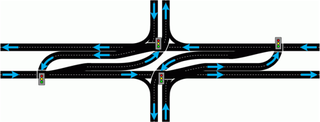
A superstreet, also known as a restricted crossing U-turn (RCUT), J-turn, or reduced conflict intersection (RCI), is a type of road intersection that is a variation of the Michigan left. In this configuration, in contrast to the Michigan left, traffic on the minor road is not permitted to proceed straight across the major road or highway. Drivers on the minor road wishing to turn left or go straight must turn right onto the major road, then, a short distance away, queue (wait) into a designated U-turn lane in the median. When traffic clears, they complete the U-turn and then either go straight or make a right turn when they intersect the other half of the minor road.

The Las Vegas Beltway is a 50-mile (80 km) beltway route circling three-quarters of the Las Vegas Valley in southern Nevada. The Las Vegas Beltway carries two numerical designations. 11.1 miles (17.9 km) of the highway, from its southern terminus at Interstate 11 (I-11) / I-515 / U.S. Route 93 (US 93) / US 95 in Henderson west and northwest to I-15, is signed as Interstate 215 (I-215) and maintained by the Nevada Department of Transportation. Clark County Route 215 (CC 215) composes the remaining approximately 38.9 miles (62.6 km) of this semi-circumferential highway, with the county's Department of Public Works responsible for all construction and maintenance. The beltway is a freeway up to Interstate Highway standards in its entirety.

<span class="mw-page-title-main">M-45 (Michigan highway)</span> State highway in Ottawa and Kent counties in Michigan, United States

M-45 is a state trunkline highway in the US state of Michigan that is also called Lake Michigan Drive. The highway runs from Agnew near Lake Michigan to the west side of Grand Rapids in the western Lower Peninsula. Lake Michigan Drive continues in each direction from M-45's termini, extending west of US Highway 31 (US 31) and east of Interstate 196 (I-196). In between, the road runs through rural and suburban areas of Ottawa and Kent counties, including the main campus of Grand Valley State University in Allendale. Lake Michigan Drive was originally part of M-50 until the mid-1960s. Previously in the 1920s and 1930s, the M-45 number was designated along a highway in the Upper Peninsula (UP).

<span class="mw-page-title-main">Texas U-turn</span> Type of road junction

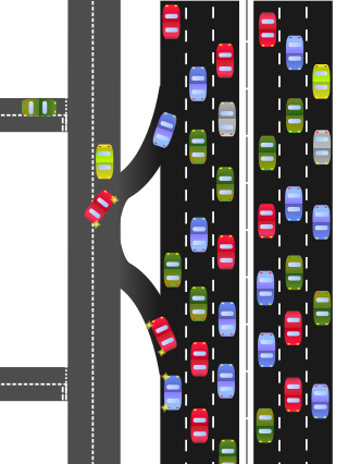
A Texas U-turn, or Texas turnaround, boomerang, or loop around, is a lane allowing cars traveling on one side of a one-way frontage road to U-turn onto the opposite frontage road. Typically controlled by yield signs, these allow U-turning traffic to bypass two traffic signals and avoid crossing the local traffic twice.

<span class="mw-page-title-main">M-143 (Michigan highway)</span> State highway in East Lansing, Ingham County, Michigan, United States

M-143, also known as Michigan Avenue, is a previously unsigned spur state trunkline highway in the south central region of the US state of Michigan. The M-143 portion of Michigan Avenue runs from the East Lansing city limit to a junction with M-43 at Grand River Avenue. This highway is the second time that there has been an M-143 in Michigan. The first was a connection to the original Cheboygan State Park. The current is a remnant of M-43 in the Lansing area.

<span class="mw-page-title-main">U.S. Route 24 in Michigan</span> U.S. Highway in Michigan

US Highway 24 is a United States Numbered Highway that runs from Minturn, Colorado, to Independence Township, Michigan. In Michigan, it is also known as Telegraph Road and runs for 79.828 miles (128.471 km) as a major north–south state trunkline highway from Bedford Township at the Ohio state line through Metro Detroit. The highway runs through three counties in southeastern Michigan, Monroe, Wayne and Oakland, as it parallels the Lake Erie shoreline and bypasses Metro Detroit on the west. Telegraph Road connects several suburbs together and passes through the western edge of Detroit before it terminates northwest of Clarkston at an interchange with Interstate 75 (I-75).

<span class="mw-page-title-main">Virginia State Route 241</span> State highway in Virginia, United States

State Route 241 is a primary state highway in the U.S. state of Virginia. The state highway runs 1.88 miles (3.03 km) from U.S. Route 1 in Huntington north to SR 236 in Alexandria. SR 241 connects US 1 and SR 236, bypass Old Town Alexandria to the southwest. The state highway connects those highways with Interstate 95 and I-495, Huntington Avenue, and Eisenhower Avenue in a series of interchanges along the boundary of Fairfax County and the independent city of Alexandria. SR 241 also connects the above highways to the Huntington station of the Washington Metro, for which the portion of the highway from US 1 to the station is part of the National Highway System.

<span class="mw-page-title-main">Continuous-flow intersection</span> Type of large road intersection

A continuous flow intersection (CFI), also called a crossover displaced left-turn, is an alternative design for an at-grade road junction. Vehicles attempting to turn across the opposing direction of traffic cross before they enter the intersection. No left turn signal in the intersection is then necessary. Instead, vehicles traveling in both directions can proceed, including through vehicles and those turning right or left, when a generic traffic signal/stop sign permits.

In the field of road transport, a turnaround is a type of junction that allows traffic traveling in one direction on a road to efficiently make a U-turn typically without backing up or making dangerous maneuvers in the middle of the traffic stream. While many junction types permit U-turns, the term turnaround often applies to road junctions built specifically for this purpose.

<span class="mw-page-title-main">Utah State Route 186</span> State highway in Utah, United States

State Route 186 (SR-186) is a state highway entirely within Salt Lake City, capital of the U.S. state of Utah. It forms a quarter-beltway connecting US-89 and I-15 leading north from Salt Lake City to I-80 leading east; as such, it effectively forms the missing (non-freeway) quarter of the I-215 belt route around the city, though it does not directly connect to I-215 at the north end. Despite this beltway role, the route passes through downtown Salt Lake City because downtown is built right up to the northern mountains surrounding City Creek Canyon. The portion of the route connecting downtown to I-80 is a high-capacity street heavily used by commuters, especially those travelling to the University of Utah or between downtown and eastern neighborhoods, but the portion on Capitol Hill north of downtown is much narrower and has sharp turns around the Capitol grounds. The roadway runs 9.34 miles (15.03 km) along Victory Road, Columbus Street, 300 North, State Street, 400 South, 500 South, and Foothill Drive.

<span class="mw-page-title-main">Virginia State Route 194</span> State highway in Virginia, United States

State Route 194 is a primary state highway in the U.S. state of Virginia. The state highway runs 5.75 miles (9.25 km) from SR 166 north to U.S. Route 60 within the independent city of Norfolk. SR 194 is a major north–south thoroughfare in the eastern part of Norfolk.

<span class="mw-page-title-main">Virginia State Route 237</span> State highway in Virginia, United States

State Route 237 is a primary state highway in the U.S. state of Virginia. The state highway runs 13.07 miles (21.03 km) from SR 236 in Fairfax east to U.S. Route 50 in Arlington. SR 237 connects Fairfax and Arlington with Falls Church. Between Fairfax and Falls Church, the state highway mostly runs concurrently with US 29. East of Falls Church, SR 237 parallels Interstate 66 (I-66) and connects several of Arlington's urban villages.

<span class="mw-page-title-main">Louisiana Highway 49</span> State highway in Louisiana, United States

Louisiana Highway 49 (LA 49) is a state highway located in Jefferson Parish, Louisiana. It runs 3.93 miles (6.32 km) in a north–south direction along Williams Boulevard from U.S. Highway 61 (US 61) to an intersection with Joe Yenni Boulevard and 44th Street in Kenner.

<span class="mw-page-title-main">Special routes of U.S. Route 13</span>

U.S. Route 13 (US 13) runs along the Atlantic coastline for over 500 miles (800 km), passing through five states. Along its route, it possessed numerous special routes, which are all loops off the mainline US 13. At present, there are at least 15 special routes in existence: two in North Carolina, five in Virginia, two in Maryland, four in Delaware, and two in Pennsylvania. 13 others have existed in the past but have been deleted.

<span class="mw-page-title-main">Business routes of Interstate 75 in Michigan</span> Highways in Michigan

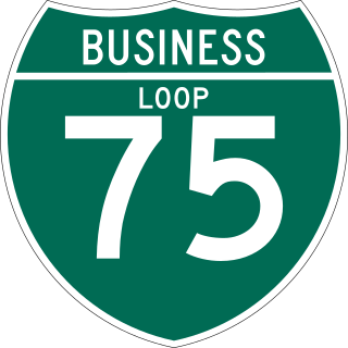
There have been nine business routes for Interstate 75 in the US state of Michigan. Numbered either Business Loop Interstate 75 or Business Spur Interstate 75 depending if they are a full business loop or a business spur, these highways are former routings of I-75's predecessor highways in the state. They were designated as I-75 was completed through the various areas of Michigan. The business loop in Pontiac runs through that city's downtown along a section of Woodward Avenue and a segment of roadway formerly used by M-24. The former Saginaw business loop was once a part of US Highway 23 (US 23), as was most of the original Bay City business loop. The roadways that make up the business loops in West Branch and Roscommon were previously part of M-76, I-75's predecessor through that part of the state. In Northern Michigan, the Grayling and Gaylord BL I-75s were part of US 27, and the two business routes in St. Ignace and Sault Ste. Marie in the Upper Peninsula of Michigan were part of US 2. A tenth business route, a loop through Indian River has been proposed. Each of the business loops connects to I-75 on both ends and runs through their respective cities' downtown areas. The two business spurs only connect to I-75 on one end and run into the appropriate downtown.

<span class="mw-page-title-main">Utah State Route 79</span> State highway in Utah, United States

State Route 79 (SR-79) is a state highway in the U.S. state of Utah that spans 4.174 miles (6.717 km) in Ogden, Weber County, with another 0.77 miles (1.24 km) consisting of the westbound segment of a brief one-way pair. The route connects SR-126 and I-15 to US-89 and SR-203 as it passes through the center of Ogden on Hinckley Drive and portions of 30th and 31st Streets. The highway was formed in 1957, initially routed from SR-38 east to SR-204. It was subsequently extended west to SR-126 and east to Harrison Boulevard (SR-203), before being extended west again to SR-108.

References

  1. 1 2 3 4 5 Federal Highway Administration (August 2004). "Alternative Intersection Treatments". Signalized Intersections: Informational Guide. Federal Highway Administration. Archived from the original on May 10, 2009. Retrieved August 1, 2011.
  2. 1 2 Michigan Department of Transportation (July 19, 2010). "Michigan Lefts". Michigan Department of Transportation. Retrieved December 20, 2010.
  3. Federal Highway Administration (August 2014). "Median U-Turn Intersection Informational Guide" (PDF).
  4. North Carolina State University (August 1, 1999). "Unconventional Left-Turn Lanes Reduce Traffic Accidents, Congestion" (Press release). North Carolina State University. Archived from the original on March 25, 2007. Retrieved December 20, 2010.
  5. Indiana Department of Transportation. "Traffic Operations: Median U-Turns". Indiana Department of Transportation. Retrieved June 24, 2017.
  6. City of Farmington Hills, Michigan (October 18, 2001). "Minutes, Planning Commission Public Hearing, September 20, 2001" (PDF). City of Farmington Hills, Michigan. Archived from the original (PDF) on September 27, 2007. Retrieved August 1, 2011.
  7. Hall, Jocelyn (September 18, 2015). "M-20 Traffic Restrictions at Leaton Road Starting Sept. 23" (Press release). Michigan Department of Transportation. Retrieved February 4, 2019. Indirect left turns, or Michigan Lefts, near the intersection will be available.
  8. 1 2 Hughes, Warren; Chappell, Debra; Chen, Shyuan-Ren (Clayton) (January 2005). "Geometric Design Treatments". Innovative Intersection Safety Improvement Strategies and Management Practices: A Domestic Scan. Federal Highway Administration. Retrieved August 17, 2013.
  9. Mississippi Department of Transportation (June 23, 2022). "J-Turn Intersections Implemented Across State (Video)" (Press release). Mississippi Department of Transportation. Retrieved June 23, 2022.
  10. 1 2 3 4 Utah Department of Transportation. "Overview". Thru Turn Intersection. Utah Department of Transportation. Archived from the original on June 23, 2012. Retrieved September 24, 2011.
  11. Doctor, Mark; Shaw, Jeff; Merritt, George (April 4, 2013). "Intersection and Interchange Geometrics" (PDF). Every Day Counts 2 Spring Virtual Summits - 21st Century Solutions (PDF). Federal Highway Administration. Retrieved August 17, 2013.
  12. Michigan Department of Transportation, Traffic and Safety division (2012). "Standard Highway Signs: Route Marker Signs". p. 101. Sign M8-5.
  13. Schroeder, Bastian; Cunningham, Chris; Ray, Brian; Daleiden, Andy; Jenior, Pete; Knudsen, Julia (August 2014). Diverging Diamond Interchange Informational Guide (PDF). Washington, DC: Federal Highway Administration Office of Safety.
  14. Google (December 20, 2010). "Mariano Otero Avenue and Manuel Gómez Morín Beltway, Guadalajara" (Map). Google Maps. Google. Retrieved December 20, 2010.
  15. Federal Highway Administration (August 2014). "Restricted Crossing U-Turn Intersection Informational Guide" (PDF). p. 10.
  16. Carton, Donna; Morris, Deborah (March 2, 2009). "P-turn to shut Frankston residents out of their street". Frankston Standard Leader . Archived from the original on November 18, 2012. Retrieved December 20, 2010.
  17. Tatman, Christian (May 15, 2015). "Roads Minister Luke Donnellan says Frankston's P-turn will remain". Frankston Standard Leader . Retrieved January 7, 2016.
  18. "Melbourne gets another P-turn with Swan Street changes". ABC News. March 17, 2019. Retrieved September 11, 2020.
  19. 1 2 Villarete, Nigel (July 17, 2014). "Understanding U-turn slots". The Philippine Star . Retrieved January 8, 2023.
  20. Clapano, Jose (June 15, 2003). "Jaworski to Bayani: Have a heart". The Philippine Star . Retrieved January 8, 2023.
  21. Chanco, Boo (August 24, 2007). "The U-turns of Bayani Fernando". The Philippine Star . Retrieved January 8, 2023.
  22. Smith, Mike (September 5, 2013). "US 280: 'Michigan Left' U-turn at Valleydale Scheduled to Be in Effect for Friday Morning Commute (animation)". The Birmingham News .
  23. "Little Love for Michigan Left". Arizona Daily Star . October 14, 2013. Retrieved March 3, 2014.
  24. "Fishers does U-turn on Michigan Left". Indy Star . February 22, 2022. Retrieved May 15, 2023.
  25. "State Street/Veterans Memorial Parkway/36th Street Intersection". Ada County Highway District . Retrieved March 11, 2019.
  26. Google (May 17, 2013). "S Claiborne Ave and S Carrollton Ave, New Orleans" (Map). Google Maps . Google. Retrieved May 17, 2013.
  27. Google (February 1, 2013). "W Metairie Avenue and Cleary Avenue, Metairie" (Map). Google Maps. Google. Retrieved February 1, 2013.
  28. Google (February 2022). "W Metairie Avenue near Cleary Avenue, Metairie". Google Street View. Google. Retrieved March 11, 2023.
  29. Google (January 2021). "Northbound on S Carrollton Ave at S Claiborne Ave, New Orleans". Google Street View. Google. Retrieved March 11, 2023.
  30. "Revisiting the Origin of the 'Michigan Left'". Michigan Radio. September 15, 2014. Retrieved November 26, 2017.
  31. Google. "8 Mile Road and Livernois Avenue" (Map). Google Maps . Google.
  32. Klinefelter, Quinn (October 5, 2015). "CuriosiD: Where Did the Michigan Left Come From?". Detroit: WDET-AM . Retrieved November 25, 2017.
  33. 1 2 Sweeney, Kate. "The Michigan Left Superstreet: Heading Eastbound: A Midwestern traffic pattern takes a detour to North Brunswick County". North Brunswick Magazine. Retrieved November 26, 2017.
  34. Schirripa, Nick (March 17, 2020). "Final Season of US 131 Reconstruction in Three Rivers Starts Monday" (Press release). Michigan Department of Transportation. Retrieved October 21, 2021.
  35. Kim, Theodore (March 23, 2010). "Officials Worry that 'Michigan Left Turn' at Plano Intersection Will Confuse Drivers". Dallas Morning News . Retrieved December 20, 2010.
  36. Davidson, Lee (November 11, 2011). "Newfangled Intersection to Open Monday in Draper". The Salt Lake Tribune . Retrieved August 17, 2013.
  37. "U-Turns Replace Left Turns at Draper intersection". KTVX. November 14, 2011. Retrieved August 17, 2013.
  38. "'Thru Turn' in Effect at Bangerter and 7800 South Intersection". West Jordan Journal. Archived from the original on February 9, 2013. Retrieved June 11, 2012.
  39. Utah Department of Transportation. "Layton Improved UDOT Open House Presentation". Utah Department of Transportation. Archived from the original on July 1, 2014. Retrieved March 3, 2014.