Superstreet

Last updated
At a superstreet, crossroad traffic intersecting with a main thoroughfare is restricted from any direct crossing or left turns. Traffic may only turn right, merging onto the main road, which then provides U-turn lane access and allows for left (or right) turns onto the intersecting crossroad. The opposite applies for countries that drive on the left. RCUT Intersection Diagram.png
At a superstreet, crossroad traffic intersecting with a main thoroughfare is restricted from any direct crossing or left turns. Traffic may only turn right, merging onto the main road, which then provides U-turn lane access and allows for left (or right) turns onto the intersecting crossroad. The opposite applies for countries that drive on the left.

A superstreet, also known as a restricted crossing U-turn (RCUT), J-turn, [1] or reduced conflict intersection (RCI), [2] is a type of road intersection that is a variation of the Michigan left. In this configuration, in contrast to the Michigan left, traffic on the minor road is not permitted to proceed straight across the major road or highway. Drivers on the minor road wishing to turn left or go straight must turn right onto the major road, then, a short distance away, queue (wait) into a designated U-turn (or crossover) lane in the median. When traffic clears, they complete the U-turn and then either go straight or make a right turn when they intersect the other half of the minor road.

Contents

The superstreet typically requires four traffic light-controlled intersections, and most traffic must pass through two of them, but each light has only two phases, greatly increasing average traffic flow; there is no need for numerous left-turn phases where most traffic is waiting for only a few cars to clear the intersection. Turning movements on roads with lower cross-traffic volumes may be controlled with stop or yield signs for turning traffic rather than with signals.

Variations

A (standard) RCUT, in contrast to a Michigan left, typically allows left turns from the major road to minor roads. A variation, designated by the US Federal Highway Administration (FHWA) as a basic RCUT, prohibits such turns, restricting movements to right-in/right-outs and median U-turns only.) When the median is relatively narrow, a "bulb-out" or "loon" protrudes from the roadway, opposite from the median crossover, to accommodate a U-turn by a long vehicle, such as a tractor trailer. [3]

Practicality

Superstreets are not very common because they require substantial right-of-way to provide a median that can accommodate truck traffic. Inconvenience to traffic on the minor road is mostly a perception issue and does not represent additional delay in most cases. [ citation needed ] However, superstreets are cheaper to construct than controlled-access highways and improve the flow of traffic on the major road.

Examples

In Port St. Lucie, Florida, the first superstreet in Florida was opened in late 2019 at the intersection of Crosstown Parkway and Floresta Drive. [4]

In May 2015, a superstreet was constructed on US 41 at SR 114 on the border between Morocco and Beaver Township in Newton County, Indiana. The state of Indiana makes a distinction between an RCUT, which it defines as having a traffic light-controlled main intersection, and a J-turn or RCI, which it defines as having the main intersection controlled by stop or yield signs. [5] Two examples of what Indiana calls a "J-turn" opened on June 30, 2016 at the intersections of US 231 with IN 62 and IN 68 near Dale. Traffic on the state roads at both intersections can only turn right, while US 231 traffic can turn left at both intersections. [6]

Troy, Michigan has a superstreet on West Big Beaver Road at Lakeview Drive. 42°33′41″N83°10′53″W / 42.561383°N 83.181310°W / 42.561383; -83.181310 . A simpler implementation is seen in Washington Township, Macomb County, Michigan at M-53 and 30 Mile Road. 42°46′21″N83°00′33″W / 42.7726°N 83.0091°W / 42.7726; -83.0091

Lake Elmo, Minnesota has a superstreet intersection on MN 36 at Keats Avenue ( 45°02′08″N92°54′14″W / 45.0356°N 92.9038°W / 45.0356; -92.9038 ).[ citation needed ]

In North Carolina, five superstreet intersections were included as a part of U.S. Route 17's recent upgrades near Wilmington, North Carolina ( 34°12′58″N78°01′08″W / 34.21603°N 78.018969°W / 34.21603; -78.018969 ).[ citation needed ][ when? ] There are also five superstreet intersections in Holly Springs along the NC 55 bypass. [7] US221 from the South Carolina stateline north to the US74 interchange is of superstreet construction

In 2011, Ohio State Route 4 Bypass in Butler County, Ohio, was reconfigured with three superstreet intersections. [8] The Ohio Department of Transportation (ODOT) is also planning to build a superstreet on US 127 at Kruckeberg Road in Greenville Township, Darke County beginning in summer 2019. ODOT materials make a distinction between the project's standard RCUT design, which ODOT terms a "partial RCUT", and what the FHWA calls a "basic RCUT", which ODOT terms an "RCUT" or a "full RCUT". [9] [10]

In Texas in 2010, several intersections on US 281 were converted to superstreet in the northern San Antonio neighborhood of Stone Oak, north of Loop 1604, to relieve rush hour congestion. [11] [12] [13] This superstreet was removed in 2019 following the start of construction to convert US 281 into a full freeway. In northwest San Antonio in 2011, two intersections on Loop 1604, north of State Highway 151, were converted to superstreet. [14] [15] These intersections, however, were also removed when 1604 was upgraded to freeway status in the area. In Austin, a superstreet was built on February 19, 2013, at the intersection of SH 71 and Farm to Market Road 973 east of Austin-Bergstrom International Airport not far from the eastern boundary of the Austin city limits. This becomes the city of Austin's first superstreet and the second city in Texas to feature this intersection design. [16] This superstreet was removed in 2019 [17] following the construction of the SH 71 Toll Lane. Another superstreet exists in Austin on Loop 360 between the intersections of Loop 1 and US 290 which provides access to Barton Creek Plaza. This superstreet allows southbound traffic on Loop 360 to travel from Loop 1 to US 290 without going through any traffic lights.

Benefits

A study showed a 20 percent overall reduction in travel time compared to similar intersections that use conventional traffic designs; intersections experience an average of 46 percent fewer reported automobile collisions – and 63 percent fewer collisions that result in personal injury. [18]

This design also is promoted as part of the FHWA's Every Day Counts initiative which started in 2011. [19]

See also

Related Research Articles

<span class="mw-page-title-main">Intersection (road)</span> Road junction where two or more roads either meet or cross at grade

An intersection or an at-grade junction is a junction where two or more roads converge, diverge, meet or cross at the same height, as opposed to an interchange, which uses bridges or tunnels to separate different roads. Major intersections are often delineated by gores and may be classified by road segments, traffic controls and lane design.

<span class="mw-page-title-main">Michigan left</span> Type of intersection

A Michigan left or P-turn is an at-grade intersection design that replaces each left (farside) turn at an intersection between a (major) divided roadway and a secondary (minor) roadway with the combination of a right (nearside) turn followed by a U-turn, or a U-turn followed by a right (nearside) turn, depending on the situation. It is in use in numerous countries.

<span class="mw-page-title-main">U.S. Route 35</span> Highway in the United States

U.S. Route 35 (US 35) is a United States Highway that runs southeast-northwest for approximately 412 miles (663 km) from the western suburbs of Charleston, West Virginia to northern Indiana. Although the highway is physically southeast-northwest, it is nominally north–south. The highway's southern terminus is in Teays Valley, West Virginia, near Scott Depot, at Interstate 64 (I-64). Its northern terminus is near Michigan City, Indiana, at US 20. The West Virginia portion of the highway is mostly expressway, becoming a freeway shortly before it crosses the Ohio River into Ohio. The Ohio portion has been upgraded to a four-lane highway/freeway between the West Virginia state line and Trotwood, west of Dayton.

<span class="mw-page-title-main">Diamond interchange</span> Common type of road junction

A diamond interchange is a common type of road junction, used where a controlled-access highway crosses a minor road.

<span class="mw-page-title-main">Diverging diamond interchange</span> Freeway interchange design

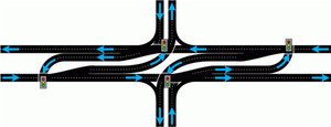
A diverging diamond interchange (DDI), also called a double crossover diamond interchange (DCD), is a subset of diamond interchange in which the opposing directions of travel on the non-freeway road cross each other on either side of the interchange so that traffic crossing the freeway on the overpass or underpass is operating on the opposite driving side from that which is customary for the jurisdiction. The crossovers may employ one-side overpasses or be at-grade and controlled by traffic light.

<span class="mw-page-title-main">Interchange (road)</span> Road junction that uses grade separation

In the field of road transport, an interchange or a grade-separated junction is a road junction that uses grade separations to allow for the movement of traffic between two or more roadways or highways, using a system of interconnecting roadways to permit traffic on at least one of the routes to pass through the junction without interruption from crossing traffic streams. It differs from a standard intersection, where roads cross at grade. Interchanges are almost always used when at least one road is a controlled-access highway or a limited-access divided highway (expressway), though they are sometimes used at junctions between surface streets.

<span class="mw-page-title-main">U.S. Route 24 in Michigan</span> U.S. Highway in Michigan

US Highway 24 is a United States Numbered Highway that runs from Minturn, Colorado, to Independence Township, Michigan. In Michigan, it is also known as Telegraph Road and runs for 79.828 miles (128.471 km) as a major north–south state trunkline highway from Bedford Township at the Ohio state line through Metro Detroit. The highway runs through three counties in southeastern Michigan, Monroe, Wayne and Oakland, as it parallels the Lake Erie shoreline and bypasses Metro Detroit on the west. Telegraph Road connects several suburbs together and passes through the western edge of Detroit before it terminates northwest of Clarkston at an interchange with Interstate 75 (I-75).

<span class="mw-page-title-main">Ohio State Route 4</span> State highway in Ohio, US

State Route 4, formerly known as Inter-county Highway 4 until 1921 and State Highway 4 in 1922, is a major north–south state highway in Ohio. It is the fifth longest state route in Ohio. Its southern terminus is at U.S. Route 42 in Cincinnati, Ohio, and its northern terminus is at U.S. Route 6 in Sandusky, Ohio. Its path is nearly ruler-straight for many miles. Some portions of the route are still marked as Dixie Highway. The northern portion was constructed by the Columbus and Sandusky Turnpike Company, see Turnpike Lands.

<span class="mw-page-title-main">Continuous-flow intersection</span> Type of large road intersection

A continuous flow intersection (CFI), also called a crossover displaced left-turn, is an alternative design for an at-grade road junction. Vehicles attempting to turn across the opposing direction of traffic cross before they enter the intersection. No left turn signal in the intersection is then necessary. Instead, vehicles traveling in both directions can proceed, including through vehicles and those turning right or left, when a generic traffic signal/stop sign permits.

A junction is where two or more roads meet.

<span class="mw-page-title-main">Texas State Highway Loop 1604</span> Loop highway around San Antonio, Texas

Loop 1604 is the outer highway loop encircling San Antonio, Texas, spanning approximately 95.6 miles (153.9 km). Originally constructed as a two-lane highway, the northern segment of the route, from US 90 in western San Antonio to Kitty Hawk Road in northeastern Bexar County, has been upgraded to a four-lane freeway. Loop 1604 is designated the Charles W. Anderson Loop in honor of former Bexar County Judge Charles W. Anderson, who died from cancer in 1964 after serving for 25 years.

In the field of road transport, a turnaround is a type of junction that allows traffic traveling in one direction on a road to efficiently make a U-turn typically without backing up or making dangerous maneuvers in the middle of the traffic stream. While many junction types permit U-turns, the term turnaround often applies to road junctions built specifically for this purpose.

<span class="mw-page-title-main">Quadrant roadway intersection</span>

A quadrant roadway intersection adds an additional "quadrant roadway" between two legs of an intersection. This roadway adds two three-way intersections in addition to the original four-way intersection, moving all left turns or right turns from the main intersection. The design is intended to improve traffic flow by reducing signal timing phases from four to two in the main intersection. The design is intended for intersections where large artery routes meet in an area of dense development and high pedestrian volume.

<span class="mw-page-title-main">U.S. Route 281 in Texas</span> Section of U.S. Highway in Texas, United States

U.S. Route 281 (US 281) is a United States Numbered Highway that runs from the Mexican border in the Rio Grande Valley to the Canadian border near Dunseith, North Dakota. In the state of Texas, the highway is a major south–north corridor, connecting Brownsville to the Oklahoma state line at the Red River in Burkburnett. Several segments of U.S. 281 are concurrent with Interstate routes, including I-69C in the Rio Grande Valley, I-37 in San Antonio, and I-44 north of Wichita Falls.

<span class="mw-page-title-main">Interstate 75 in Ohio</span> Interstate Highway in Ohio, United States

Interstate 75 (I-75) runs from Cincinnati to Toledo by way of Dayton in the US state of Ohio. The highway enters the state running concurrently with I-71 from Kentucky on the Brent Spence Bridge over the Ohio River and into the Bluegrass region. I-75 continues along the Mill Creek Expressway northward to the Butler County line just north of I-275. From there, the freeway runs into the Miami Valley and then passes through the Great Black Swamp before crossing into Michigan.

<span class="mw-page-title-main">U.S. Route 30 in Ohio</span> Section of U.S. Highway in Ohio, United States

U.S. Route 30 (US 30) is a United States Numbered Highway that runs from Astoria, Oregon, to Atlantic City, New Jersey. In the state of Ohio, it is a major, 245-mile-long (394 km), east–west highway that runs through the northern section of the state. Overall, the highway runs through rural areas dominated by farm fields or woodlands; some segments are urban in character in the Mansfield and Canton areas.

<span class="mw-page-title-main">U.S. Route 23 in Ohio</span> Section of U.S. Highway in Ohio, United States

U.S. Route 23 (US 23) is a United States Numbered Highway that runs from Jacksonville, Florida, to Mackinaw City, Michigan. In the state of Ohio, it is a major north–south state highway that runs from the Kentucky border at Portsmouth to the Michigan border at Sylvania.

<span class="mw-page-title-main">U.S. Route 127 in Ohio</span>

US Highway 127 (US 127) is a part of the United States Numbered Highway System that runs from Chattanooga, Tennessee, to the Lower Peninsula of Michigan. In Ohio, the highway runs 194.27 miles (312.65 km) from the Ohio River in Cincinnati to the Michigan state line north of West Unity. US 127 runs south to north in Ohio's westernmost counties along the border of Indiana. The highway is a main route connecting many small towns, including eight county seats. The highway was first designated in 1926. Its route ended in downtown Toledo before being realigned to its current route in 1930.

<span class="mw-page-title-main">Special routes of U.S. Route 15</span>

Several special routes of U.S. Route 15 (US 15) exist. In order from south to north, they are as follows.

<span class="mw-page-title-main">Offset T-intersection</span> Type of road intersections

An offset T-intersection is an at-grade road intersection where a conventional four leg intersection is split into two three-leg T-intersections to reduce the number of conflicts and improve traffic flow. Building the offset T-intersections as continuous green T-intersections, there is a single stop on the arterial road, only. A higher volume of through traffic on the cross road, or on unsignalized intersections, a rebuild to a conventional four-leg intersection may be adequate, also when the offset is a few feet only like staggered junctions causing slower traffic for a longer time on the arterial road.

References

  1. Staff (October 2009). "Techbrief: Restricted Crossing U-Turn Intersection (FHWA-HRT-09-059)". Alternative Intersections/Interchanges: Information Report (AIIR) (FHWA-HRT-09-060). Federal Highway Administration . Retrieved August 24, 2012.
  2. Minnesota Department of Transportation, Reduced Conflict Intersections, accessed November 2014
  3. Staff (March 8, 2016) [April 2010]. "Restricted Crossing U-Turn Intersection". Alternative Intersections/Interchanges: Informational Report (AIIR) (Technical report). Washington, D.C.: Federal Highway Administration. FHWA-HRT-09-060. Retrieved June 24, 2017.
  4. "New Traffic Configuration at Crosstown & Floresta Dr". City of Port St. Lucie, Florida. August 5, 2019. Retrieved January 19, 2020.
  5. "Traffic Operations: Median U-Turns". Indiana Department of Transportation . Retrieved June 24, 2017.
  6. Taylor, Britney (June 29, 2016). "J-Turns At U.S. 231 Intersection To Open Near Dale, Indiana". Evansville, Indiana: WEVV-TV . Retrieved July 10, 2017.
  7. Kenney, Andrew. "Traffic rolls onto new Holly Springs superstreet". News & Observer. Retrieved 3 December 2013.
  8. "State Route 4 Bypass Widening". Butler County Transportation Improvement District. July 21, 2011. Retrieved December 11, 2017.
  9. Martin, Erik (June 15, 2017). "State agrees to fund 127/Kruckeberg intersection reconstruction". The Daily Advocate . Greenville, Ohio. Archived from the original on December 12, 2017. Retrieved June 17, 2017.
  10. "Feasibility Study: WYA-23 Intersection Improvements" (PDF). Ohio Department of Transportation. August 2021. PID 109362. Archived (PDF) from the original on April 10, 2022. Retrieved April 10, 2022.
  11. New, Brian (March 11, 2010). "Super street construction on US 281 to begin on Monday". KENS . Retrieved March 23, 2013.
  12. "US281 Superstreet". 4-1-1 on 281. Alamo Regional Mobility Authority . Retrieved March 23, 2013.
  13. "Loop 360 - Archive: Innovative Intersections: The Superstreet (RCUT)". Texas Department of Transportation . Retrieved March 23, 2013.
  14. "Loop 1604 Super Street". Alamo Regional Mobility Authority . Retrieved March 23, 2013.
  15. "Loop 1604 superstreet promises easier flow". KENS. September 15, 2011. Retrieved March 23, 2013.
  16. "Super street coming to East Austin". Austin, TX: KVUE-TV. February 19, 2013. Retrieved February 19, 2013.
  17. "Austin Tollway Regional Map". Central Texas Regional Mobility Aushority. Retrieved May 31, 2020.
  18. PhysOrg: No left turn: 'Superstreet' traffic design improves travel time, safety
  19. Schroeder, Bastian; Cunningham, Chris; Ray, Brian; Daleiden, Andy; Jenior, Pete; Knudsen, Julia (August 2014). Diverging Diamond Interchange Informational Guide (PDF). Washington, DC: Federal Highway Administration Office of Safety.