
Courtland is an incorporated town in Southampton County, Virginia, United States. It is the county seat of Southampton County.
Short Gap is an unincorporated community in Mineral County, West Virginia, United States, located at the intersection of Routes 956 and 28; approximately eight miles from Cumberland, Maryland. The community is home to Frankfort High School, as well as Frankfort Middle School, which serve the northern part of Mineral County, including students from the towns of Ridgeley and Fort Ashby. The ZIP codes for Short Gap are 26753 and 26726.
Montpelier is an unincorporated community in Hanover County in the central region of the U.S. state of Virginia. Montpelier is on U.S. Route 33, which was long named as "the Mountain Road" between Richmond and the Blue Ridge Mountains. The community is located midway between Richmond and President James Madison's home "Montpelier", and may have been named for the famous estate, which is a tourist attraction.

Aurora is an unincorporated community and census-designated place in southeastern Preston County, West Virginia, United States. As of the 2010 census, its population was 201. Aurora is located on U.S. Route 50 between the Maryland state line and the town of Rowlesburg. Cathedral State Park is located to the east of Aurora's post office.
Files Crossroad is an unincorporated community in Berkeley County, West Virginia, United States. The community is located east of Martinsburg on West Virginia Route 45 at its crossroads with County Route 45/4. The community was originally known as Smoketown, hence the name of its historic Smoketown Cemetery.
Ballsville is an unincorporated community in Powhatan County, Virginia. The community is located approximately forty miles due west of Richmond. It is on Virginia State Route 13 between Powhatan, Virginia and Cumberland, Virginia.

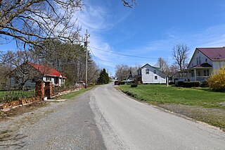
Hanover is an unincorporated community and census-designated place (CDP) in Hanover County, Virginia, United States. It is the county seat and is located at the junction of U.S. Route 301 and State Route 54 south of the Pamunkey River. While historically known as Hanover Courthouse, the U.S. Geological Survey, Census Bureau, Postal Service and residents refer to it as "Hanover". The population as of the 2010 census was 252.

The Hanover Tavern is a community center, theatre, and recreational tavern located in Hanover, Virginia. Originally built in 1733, it is one of the oldest taverns in the United States.
Hanover County Courthouse Historic District is a national historic district located at Hanover Courthouse, Hanover County, Virginia, USA. The district includes four contributing buildings in the county seat of Hanover Courthouse. They are the separately listed Hanover County Courthouse (1735), the old jail (1835), the clerk's office, and the Hanover Tavern now known as the Barksdale Theatre.
Greenville is an unincorporated community in Monroe County, West Virginia, United States. Greenville is located on West Virginia Route 122, west of Union. The community was formerly called Centreville.
Aylett is an unincorporated community in King William County, Virginia, United States. It is located where Virginia State Route 360 crosses the Mattaponi River. William Aylett and his family had several prominent warehouses and mills in the area.
Yancey Mills is an unincorporated community in Albemarle County, Virginia, United States.

Ivy is a census-designated place (CDP) in Albemarle County, Virginia, United States. The population as of the 2010 Census was 905. It is a small unincorporated community located on U.S. Route 250, just west of Charlottesville.
Lowell is an unincorporated community in Summers County, West Virginia, United States. Lowell is located on the Greenbrier River, east of Hinton and southwest of Alderson. The community was first settled in 1770 and is the oldest community in Summers County.
Bells Crossroad is an unincorporated community in Spotsylvania County, in the U.S. state of Virginia. This community is centered on the intersection of Stubbs Bridge Road and Lawyer's Road.

The Malden Inn is an historic, American building that is located in the unincorporated bedroom community of Malden, Pennsylvania at the junction of South Malden Road and Old U.S. Route 40 (US40).

Woodlawn, also known as the Trible House, is a historic home located near Miller's Tavern, Essex County, Virginia. It was built about 1816–1820, and is a 1+1⁄2-story, two bay, frame dwelling with a gambrel roof. It features two exterior end chimneys constructed of brick. A lean-to addition was built about 1840.
Orange Springs is a historic 52-acre home, farm complex, and former resort spa located near Unionville, Orange County, Virginia, just east of the intersection of US Route 522 and Route 629, located along Route 629, overlooking Terry's Run.

Yates Tavern, also known as Yancy Cabin, is a historic tavern located near Gretna, Pittsylvania County, Virginia. The building dates to the late-18th or early-19th century, and is a two-story, frame building sheathed in weatherboard. It measures approximately 18 feet by 24 feet and has eight-inch jetty on each long side at the second-floor level. It is representative of a traditional hall-and-parlor Tidewater house. The building was occupied by a tavern in the early-19th century. It was restored in the 1970s.

The Millers Tavern Rural Historic District encompasses a large rural landscape in western Essex County, Virginia, extending partly into eastern King and Queen County. In an area of 3,900 acres (1,600 ha) is a landscape that has seen only modest alterations since the 17th century, with predominantly agricultural uses persisting. Most of the farm properties in the district are modest, with vernacular building stock dating from the late 18th century to the mid-20th century. Sprinkled throughout the district are a few churches and grist mills, as well as the eponymous Miller's Tavern. The district is roughly bounded by U.S. Route 360 and Howerton, Dunbrooke, Latanes Mill, and Midway Rds.


