Nora Springs, Iowa | |
---|---|
![]() Location of Nora Springs, Iowa | |
Coordinates: 43°8′38″N93°0′32″W / 43.14389°N 93.00889°W | |
Country | ![]() |
State | ![]() |
Counties | Floyd, Cerro Gordo |
Area | |
• Total | 2.24 sq mi (5.81 km2) |
• Land | 2.22 sq mi (5.74 km2) |
• Water | 0.03 sq mi (0.07 km2) |
Elevation | 1,086 ft (331 m) |
Population (2020) | |
• Total | 1,369 |
• Density | 617.78/sq mi (238.48/km2) |
Time zone | UTC-6 (Central (CST)) |
• Summer (DST) | UTC-5 (CDT) |
ZIP code | 50458 |
Area code | 641 |
FIPS code | 19-56910 |
GNIS feature ID | 0459546 |
Website | http://www.citynorasprings.com |
Nora Springs is a city that is partially in Cerro Gordo and Floyd counties in the U.S. state of Iowa, along the Shell Rock River. The population was 1,369 at the time of the 2020 census. [2]
The Cerro Gordo County portion of Nora Springs is part of the Mason City Micropolitan Statistical Area.
Nora Springs was founded in 1857 and was incorporated in 1875.
Nora Springs is located at 43°8′38″N93°0′32″W / 43.14389°N 93.00889°W (43.144010, −93.008929). [3]
According to the United States Census Bureau, the city has a total area of 2.22 square miles (5.75 km2), of which 2.19 square miles (5.67 km2) is land and 0.03 square miles (0.08 km2) is water. [4]
Year | Pop. | ±% |
---|---|---|
1880 | 617 | — |
1890 | 846 | +37.1% |
1900 | 1,209 | +42.9% |
1910 | 985 | −18.5% |
1920 | 1,055 | +7.1% |
1930 | 1,070 | +1.4% |
1940 | 1,198 | +12.0% |
1950 | 1,257 | +4.9% |
1960 | 1,275 | +1.4% |
1970 | 1,337 | +4.9% |
1980 | 1,572 | +17.6% |
1990 | 1,505 | −4.3% |
2000 | 1,532 | +1.8% |
2010 | 1,431 | −6.6% |
2020 | 1,369 | −4.3% |
Source: "U.S. Census website". United States Census Bureau . Retrieved 2020-03-29. and Iowa Data Center Source: |
As of the census [6] of 2010, there were 1,431 people, 577 households, and 388 families residing in the city. The population density was 653.4 inhabitants per square mile (252.3/km2). There were 636 housing units at an average density of 290.4 per square mile (112.1/km2). The racial makeup of the city was 99.1% White, 0.1% African American, 0.2% Asian, 0.1% from other races, and 0.6% from two or more races. Hispanic or Latino of any race were 1.4% of the population.
There were 577 households, of which 32.2% had children under the age of 18 living with them, 54.9% were married couples living together, 9.9% had a female householder with no husband present, 2.4% had a male householder with no wife present, and 32.8% were non-families. 28.4% of all households were made up of individuals, and 13.4% had someone living alone who was 65 years of age or older. The average household size was 2.37 and the average family size was 2.91.
The median age in the city was 41.2 years. 24% of residents were under the age of 18; 7.1% were between the ages of 18 and 24; 23.3% were from 25 to 44; 27.5% were from 45 to 64; and 18% were 65 years of age or older. The gender makeup of the city was 49.0% male and 51.0% female.
As of the census [7] of 2000, there were 1,532 people, 597 households, and 401 families residing in the city. The population density was 700.5 inhabitants per square mile (270.5/km2). There were 629 housing units at an average density of 287.6 per square mile (111.0/km2). The racial makeup of the city was 99.54% White, 0.07% African American, 0.13% Native American, 0.07% from other races, and 0.20% from two or more races. Hispanic or Latino of any race were 0.85% of the population.
There were 597 households, out of which 31.8% had children under the age of 18 living with them, 55.9% were married couples living together, 7.9% had a female householder with no husband present, and 32.8% were non-families. 29.6% of all households were made up of individuals, and 14.1% had someone living alone who was 65 years of age or older. The average household size was 2.39 and the average family size was 2.95.
24.0% are under the age of 18, 7.8% from 18 to 24, 26.6% from 25 to 44, 23.2% from 45 to 64, and 18.4% who were 65 years of age or older. The median age was 40 years. For every 100 females, there were 95.2 males. For every 100 females age 18 and over, there were 89.7 males.
The median income for a household in the city was $34,926, and the median income for a family was $43,516. Males had a median income of $28,043 versus $21,536 for females. The per capita income for the city was $16,246. About 3.0% of families and 5.3% of the population were below the poverty line, including 3.9% of those under age 18 and 7.5% of those age 65 or over.
The last week of June always marks Nora Springs Buffalo Days. Festivities include a parade, entertainment at Boulder Park such as food vendors, and inflatable rides. Other activities include a 5K Run/Walk and Bingo. At the Fire Department the Fireman's Ball is held from 9 p.m. to 1 a.m. [8]
Its public schools are operated by the Central Springs Community School District, [9] established on July 1, 2011, by the merger of North Central Community School District and Nora Springs–Rock Falls Community School District. [10] The athletic teams are the Central Springs Panthers. [11]
All high school students in the district, grades 9-12, as well as K-3 elementary students from the Plymouth, Manly, and Hanlontown area attend school at the Manly site. Meanwhile, all middle school students, grades 4-8, plus grades K-3 from the Nora Springs and Rock Falls area, plus those from the unincorported community of Portland, attend school at the Nora Springs site. [12] The school colors are black and blue, the mascot being a panther. [13]
National Register of Historic Places listings in Floyd County, Iowa
Union County is the southernmost county in the U.S. state of South Dakota. As of the 2020 census, the population was 16,811, making it the 13th most populous county in South Dakota. Its county seat has been Elk Point since April 30, 1865. Originally named Cole County, its name was changed to Union on January 7, 1864, because of Civil War sentiment.
Floyd County is a county located in the U.S. state of Iowa. As of the 2020 census, the population was 15,627. The county seat is Charles City.
Gilbertville is a city in Black Hawk County, Iowa, United States. The population was 794 at the time of the 2020 census. It is part of the Waterloo–Cedar Falls Metropolitan Statistical Area.
La Porte City is a city in Black Hawk County, Iowa, United States. The population was 2,284 at the 2020 census. It is part of the Waterloo–Cedar Falls Metropolitan Statistical Area.
Yetter is a city in Calhoun County, Iowa, United States. The population was 19 at the time of the 2020 census.
Wiota is a city in Cass County, Iowa, United States. The population was 91 at the time of the 2020 census.
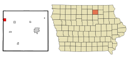
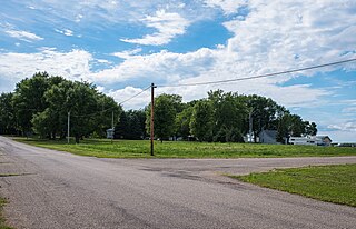
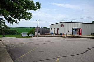
Plymouth is a city in Cerro Gordo County, Iowa, United States, along the Shell Rock River. The population was 375 at the time of the 2020 census. It is part of the Mason City Micropolitan Statistical Area.
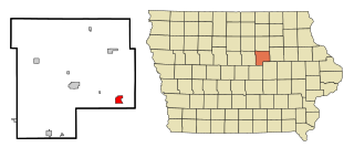
Rock Falls is a city in Cerro Gordo County, Iowa, United States, along the Shell Rock River. The population was 150 at the time of the 2020 census. It is part of the Mason City Micropolitan Statistical Area.
Everly is a city in Clay County, Iowa, United States. The population was 575 in the 2020 census, a decline from 647 in 2000. The Ocheyedan River flows to the south and west of the city. Famous people born here include Vern Fear.
Superior is a city in Dickinson County, Iowa, United States. The population was 132 at the time of the 2020 census.
Maynard is a city in Fayette County, Iowa, United States. The population was 476 at the time of the 2020 census.
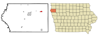
Reinbeck is a city in Grundy County, Iowa, United States. The population was 1,662 at the 2020 census—a five percent decrease from the population of 1,751 in 2000. It is part of the Waterloo–Cedar Falls Metropolitan Statistical Area and is in the Cedar Valley.
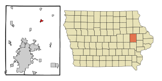
Central City is a city in Linn County, Iowa, United States. The population was 1,264 at the 2020 census. It is part of the Cedar Rapids Metropolitan Statistical Area.
College Springs is a city in Page County, Iowa, United States. The population was 172 at the 2020 census.
Merrill is a city in Plymouth County, Iowa, United States, along the Floyd River. The population was 717 at the time of the 2020 census.
Remsen is a city in Plymouth County, Iowa, United States. The population was 1,678 at the time of the 2020 census.
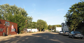
Westfield is a city in Plymouth County, Iowa, United States. The population was 123 at the time of the 2020 census. It is the westernmost point in Iowa, this being due to a bend in the Big Sioux River. The nearby Broken Kettle wildlife refuge is one of the few places in Iowa where prairie rattlesnakes are commonly found.
Hanlontown is a city in Worth County, Iowa, United States. The population was 206 at the time of the 2020 census. It is part of the Mason City Micropolitan Statistical Area.
Manly is a city in Worth County, Iowa, United States, whose population was 1,256 at the time of the 2020 census. It is part of the Mason City Micropolitan Statistical Area.
Plymouth is a city in Hennepin County in the U.S. state of Minnesota. A suburb in the Minneapolis–Saint Paul metropolitan area, the city is about 10 miles (16 km) west of downtown Minneapolis.The population was 81,026 at the 2020 census, making it Minnesota's 7th-largest city.