
Capon Springs is an unincorporated community in Hampshire County, West Virginia, United States. According to the 2000 census, the Capon Springs community has a population of 95.
Marlowe is an unincorporated community on U.S. Route 11 in Berkeley County, West Virginia, United States.
Emmons is an unincorporated community located on the Big Coal River in Boone and Kanawha counties in the U.S. state of West Virginia. Jay Rockefeller's political affiliation with West Virginia began in 1964–1965 while he served as a VISTA volunteer in Emmons.
The following is a set–index article, providing a list of lists, for the cities, towns and villages within the jurisdictional United States. It is divided, alphabetically, according to the state, territory, or district name in which they are located.
Belva is an unincorporated community and census-designated place in west Nicholas County and north Fayette County, West Virginia, United States; while the CDP only includes the Nicholas County portion, the Fayette County portion is considered part of the community. The town is situated at the bottomland surrounding the convergence of Bells Creek with Twentymile Creek and, subsequently, Twenty Mile Creek with the Gauley River. Belva is also the location of the convergence of two state highways: West Virginia Route 16 and West Virginia Route 39.

The following outline is provided as an overview of and topical guide to the U.S. state of West Virginia:
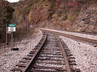
Amigo is an unincorporated community in Raleigh County, West Virginia, United States. The community is located on West Virginia Route 16 at the confluence of the Guyandotte River and Winding Gulf. The Amigo Post Office closed on October 22, 2011; it was established in 1915.
Maidsville is an unincorporated community in Monongalia County, West Virginia, United States. Maidsville is located along West Virginia Route 100, 4.5 miles (7.2 km) north-northwest of downtown Morgantown.

Idamay is a census-designated place (CDP) in Marion County, West Virginia, United States. Idamay is located along West Virginia Route 218, 1 mile (1.6 km) south of Farmington. Idamay has a post office with ZIP code 26576. As of the 2010 census, its population was 611.
Russellville is an unincorporated community in Fayette County, West Virginia, United States. Russellville is located along West Virginia Route 41, 14.5 miles (23.3 km) south of Summersville.

Raleigh is an unincorporated community and coal town in Raleigh County, West Virginia, United States. Raleigh is 1.5 miles (2.4 km) southeast of downtown Beckley. Raleigh has a post office with ZIP code 25911.
Redstar is an unincorporated community in Fayette County, West Virginia, United States. Redstar is 2.5 miles (4.0 km) south of Oak Hill. Redstar had a post office with ZIP code 25914, which closed on January 20, 2007.
Dixie is a census-designated place (CDP) in Fayette and Nicholas counties, West Virginia, United States. Dixie is located on West Virginia Route 16, 5.5 miles (8.9 km) north of Gauley Bridge. Dixie has a post office with ZIP code 25059. As of the 2010 census, its population was 291, with 202 residents in Nicholas County and 89 in Fayette County.
Lakin is an unincorporated community in Mason County, West Virginia, United States. Lakin is located on West Virginia Route 62, 5 miles (8.0 km) southwest of Mason.
Landville is an unincorporated community in Logan County, West Virginia, United States. Landville is located on the Guyandotte River and West Virginia Route 80, 2 miles (3.2 km) south-southeast of Man. Landville had a post office, which closed on July 9, 1988.
Beckwith is an unincorporated community in Fayette County, West Virginia, United States. Beckwith is located on West Virginia Route 16 and Laurel Creek, 4.1 miles (6.6 km) northwest of Fayetteville. Beckwith had a post office, which closed on October 3, 1998. The community has the name of P. D. Beckwith.
Harvey is an unincorporated community in Fayette County, West Virginia, United States. Harvey is located on County Route 25, 2.8 miles (4.5 km) south-southeast of Oak Hill.
Long Branch is an unincorporated community in Fayette County, West Virginia, United States. Long Branch is located near the West Virginia Turnpike, 1.1 miles (1.8 km) northwest of Pax. Long Branch had a post office, which closed on October 3, 1998.
Quinnimont is an unincorporated community in Fayette County, West Virginia, United States. Quinnimont is located on West Virginia Route 41 near the New River, 7.1 miles (11.4 km) east-southeast of Mount Hope. Quinnimont had a post office, which opened on February 23, 1874, and closed on February 1, 1997.
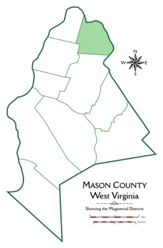
Graham Magisterial District is one of ten magisterial districts in Mason County, West Virginia, United States. The district was originally established as a civil township in 1863, and converted into a magisterial district in 1872. In 2020, Graham District was home to 2,618 people.


