Prehistoric agriculture in the Southwestern United States

Last updated
A map of the pre-historic cultures of the American Southwest ca 1200 CE. Several Hohokam settlements are shown Oasisamerica-Hohokam.png
A map of the pre-historic cultures of the American Southwest ca 1200 CE. Several Hohokam settlements are shown

The agricultural practices of the Native Americans inhabiting the American Southwest, which includes the states of Arizona and New Mexico plus portions of surrounding states and neighboring Mexico, are influenced by the low levels of precipitation in the region. Irrigation and several techniques of water harvesting and conservation were essential for successful agriculture. To take advantage of limited water, the southwestern Native Americans utilized irrigation canals, terraces (trincheras), rock mulches, and floodplain cultivation. Success in agriculture enabled some Native Americans to live in communities which numbered in the thousands as compared to their former lives as hunter-gatherers in which their bands numbered only a few dozen.

Contents

Maize (corn), the dominant crop, was introduced from Mesoamerica and cultivated in the present-day Southwest U.S. by 2100 BCE at the latest. Non-migrant cultures based on farming developed afterwards including the Hohokam, Mogollon, Ancestral Puebloans, and Patayan.

The environmental challenges of agriculture in the Southwest resulted in the demise or evolution of many once-successful agricultural societies, but they left behind impressive archeological evidence of their existence. Some agricultural cultures, such as the Pueblos of the United States and the Yaqui and Mayo of Mexico, were durable and survive into the 21st century.

Earliest agriculture

Varieties of maize Zea mays.jpg
Varieties of maize
At Mesa Verde, the people lived below and farmed on top of the mesa contending with both short growing seasons and frequent drought Mesa Verde, Colorado.jpg
At Mesa Verde, the people lived below and farmed on top of the mesa contending with both short growing seasons and frequent drought

Although it is possible that indigenous peoples grew several native plants such as gourds and chenopods at very early dates, the first evidence of maize cultivation in the Southwest dates from about 2100 BCE. Small, primitive maize cobs have been found at five different sites in New Mexico and Arizona. The climatic range of the sites is wide as they range from the Tucson basin in the Arizona desert, at an elevation of 700 m (2300 ft), to a rocky cave on the Colorado plateau at 2200 m (7200 ft). That suggests that the primitive maize they grew was already adapted to being grown in both hot and dry and short-season climates. [1]

Maize reached the Southwest via an unknown route from Mexico. Its diffusion was relatively rapid. One theory is that the maize cultivation was carried northward from central Mexico by migrating farmers, most likely speakers of a Uto-Aztecan language. Another theory, more accepted among scholars, is that maize was diffused northward from group to group rather than migrants. The first cultivation of maize in the Southwest came during a climatic period when precipitation was relatively high. Although maize cultivation spread rapidly in the Southwest, the hunter-gatherers living in the region did not immediately adopt it as their primary source of nutrition, but rather integrated maize cultivation as one element, initially a minor element, in their foraging strategy. Hunter-gatherers usually exploit a broad spectrum of food sources to minimize risk in the event that one or more of their principal sources of food fails. [2]

Pre-agricultural hunter-gatherer bands were typically small, comprising only 10–50 members, although several bands joined on occasion for ceremonies or mutual cooperation. As maize cultivation became more important, communities became larger and more settled, although hunting and gathering wild foods remained important. Several of the agricultural towns in the Southwest, such as Casa Grande and Casas Grandes plus Pueblo and Opata settlements may have had populations of 2,000 or more at the peak of their influence. Many more people lived in smaller satellite settlements of 200 to 300 people each, or in isolated settlements.

Maize cultivation in the Southwest predates by many centuries maize cultivation in the eastern United States which has a much more favorable climate for agriculture.

Crops

Southwestern farmers probably began experimenting with agriculture by facilitating the growth of wild grains such as amaranth and chenopods and gourds for edible seeds and containers. The earliest maize known to have been grown in the Southwest was a popcorn variety with a cob only about one or two inches long. It was not a very productive crop. More productive varieties were developed by Southwestern farmers or introduced from Mesoamerica. Beans and squashes were also introduced from Mesoamerica, although the drought-resistant tepary bean was native. Cotton, presumably cultivated, is found at archaeological sites dating about 1200 BC in the Tucson basin and evidence of tobacco use, and possibly cultivation, occurs at about the same time. [3] Agave, especially Agave murpheyi , was a major food source of the Hohokam and was grown on dry hillsides where other crops would not grow. The early farmers also consumed and possibly facilitated the growth of cactus fruit, mesquite bean, and species of wild grasses for their edible seeds. [4]

Tools

Southwestern Indians did not have draft animals or metal tools. Planting was done with a sharpened, fire-hardened stick, a tool that is now known as a dibble stick. Hoes and shovels were made of wood and the shoulder bones of buffalo and other large animals. Mussel shells, pottery, and rocks were also used as planting and digging tools. Indians did not customarily fertilize their field with organic matter, but rather relied on crop rotation, fallowing, and silt deposit from rainwater runoff. Fire was sometimes used to clear and fertilize land with ash. [5] They transported water in large pottery jugs for hand watering of garden plots.

Water management

At Chaco Canyon, the Ancestral Puebloans captured rainwater runoff from the mesas and directed it to their small fields, thus enabling them to create a complex society in an austere high-altitude desert Chaco Canyon Chetro Ketl great kiva plaza NPS.jpg
At Chaco Canyon, the Ancestral Puebloans captured rainwater runoff from the mesas and directed it to their small fields, thus enabling them to create a complex society in an austere high-altitude desert

Agriculture at the lower elevations of the Southwest is difficult without irrigation as precipitation is sparse and unreliable. Higher elevations, about 5,000 feet (1,500 m), may have greater precipitation but also have cooler temperatures, shorter growing seasons, and less fertile soils. In either case agriculture was a challenge. The agricultural strategies used by ancient Southwestern farmers included: "seed selection, fallowing fields, planting in different locations, staggering the times of plantings, and maintaining separate plantings of different corn and bean varieties." [6]

Canal irrigation

The Las Capas site near Tucson features the earliest irrigation system, dating to 1200 BCE, found in North America. The network of canals and small fields, each about 250 sq ft (23 m2) in size, covers more than 100 acres (40 hectares) indicating a sizable community of people with the organization to undertake substantial public works project. [7] Also found at the site are tobacco pipes, the oldest smoking pipes yet found. This site may have supported 150 people. Corn grown at Las Capas was similar to today's popcorn. Archaeologists speculate that the kernels were popped and then ground into meal to make tortillas. [8]

The Las Capas people were probably the forerunners of the Hohokam, the most accomplished farmers of the Southwest. The Hohokam lived in the Gila and Salt river valleys of Arizona between the first century and 1450 CE. Their society bloomed about 750 CE, probably as a result of their agricultural success. The Hohokam constructed a vast system of canals to irrigate thousands of acres of cropland. Their main canals were as much as 10 m (10 yards) wide, four m (4 yards) deep, and extended across the river valleys for as much as 30 km (19 mi). [9] At the peak of their culture in the 14th century, the Hohokam may have numbered 40,000 people. [10]

The sudden disappearance of the Hohokam between 1400 and 1450 CE is a puzzle. Archaeologists speculate that maintenance of the canals was difficult and sediment accumulated over the centuries. Farmers were forced to abandon old canals and move further from the river, increasing the technological challenge to farming. After a thousand years of success, the Hohokam were unable to sustain their intensive agricultural economy. They disappeared from the archaeological record and when Spanish explorers reached the Gila and Salt valleys in the 16th century, they were only sparsely populated by the Upper Pima and Tohono O'odham (Papago) Indians, the likely descendants of the Hohokam. [11]

After the Hohokam disappeared, Spanish explorers of the 16th century noted the use of canal irrigation in only two areas of the Southwest: eastern Sonora, primarily practiced by the Opata and Lower Pima, and among the Pueblos of northern New Mexico. Irrigation by the Opata and Pueblos had different objectives. In Sonora, with a long growing season, two crops of maize a year were grown in river valleys. The spring crop during the dry season was dependent upon irrigation; the summer and fall crop during the rainy season utilized irrigation to supplement rainfall. The necessity of irrigation probably required a high level of social organization. In New Mexico, with only one crop of maize per year possible, irrigation was supplemental and the lesser dependence on irrigation implies less social organization than in Sonora. [12]

Trincheras

The rock walls called trincheras are visible in this photo taken at the Cerro de Trincheras near Trincheras, Sonora. Agriculture at this site dates from 1300 to 1500 CE Trincheras at Cerro De Trincheras.jpg
The rock walls called trincheras are visible in this photo taken at the Cerro de Trincheras near Trincheras, Sonora. Agriculture at this site dates from 1300 to 1500 CE

Trincheras (Spanish for trenches or fortifications) are rock walls or terraces built on hillsides by pre-historic Indians. Trincheras are common throughout the Southwest. They date back to near the beginning of Southwestern agriculture. By about 1300 BCE, at Casas Grandes, in Chihuahua, early farmers constructed hilltop fortresses and trincheras on hillsides, public works that required considerable labor and organization which implies a settled and numerous community. [13]

Trincheras served a number of purposes such as defense, homesites, and agriculture. [14] Their agricultural purposes were to provide farmers a level planting surface and aid in preventing erosion, collecting and managing water, and preventing frost damage. [15] Hillside agriculture in the small fields created by trincheras was often of secondary importance to floodplain farming. Trinchera agriculture was probably used to grow all crops. Southwestern Indian farmers often cultivated several different fields and crops in different locations and environments to reduce the risk of crop failure. Should one or more plantings fail for whatever reason, other plantings might succeed.

Four types of trincheras were constructed. Check dams were constructed across drainages to capture runoff from precipitation; terraces and linear borders were built along contours to provide a level planting surface or homesite; and, near permanent streams and rivers, riverside terraces were constructed to capture the overflow of water from floods. Trincheras were extensive. For example, archaeologists have found 183 upland farming locations near the site of Casas Grandes with trincheras that have a cumulative length of 26,919 m, almost 18 miles. [16] This extensive use and importance of trincheras at Casas Grandes was replicated in many other agricultural societies in the Southwest.

Lithic mulch

Lithic mulch was another technique of agriculture in the Southwest. Rocks or cobbles were used as a mulch around growing plants and in fields. The rocks acted as a mulch to preserve moisture, decrease soil erosion, control weeds, and increase nighttime temperatures through radiation and retention of heat by the rocks. [17] In the 1980s, archaeologists discovered that large areas of agave, especially Agave murpheyi , had been cultivated in rock mounds by the Hohokam in the Tucson Basin, near the city of Marana. [18] Seventy-eight square kilometers (almost 20,000 acres) of former agave fields have since been discovered, mostly between Phoenix and Tucson. Undoubtedly many other fields have been destroyed or are undetected by archaeologists. [19] Northern New Mexico also has the remnants of many fields mulched with rocks. Maize and cotton pollen have been found in soil associated with the rock mounds and mulch. [20]

Floodplain cultivation

Snaketown: in 1000 CE, this was a flourishing Hohokam settlement of more than 1,000 people with canals bringing water from the nearby Gila River HohokamPima1.JPG
Snaketown: in 1000 CE, this was a flourishing Hohokam settlement of more than 1,000 people with canals bringing water from the nearby Gila River

In their effort to attain food security, Southwestern Indians cultivated the floodplains of rivers and ephemeral streams. Crops were planted on floodplains and islands to take advantage of high water when the river or stream overflowed, saturated the land with water and enriched the soil with silt. This method was most effective when floods came at predictable times. Floodplain cultivation was used instead of canal irrigation by the La Junta Indians (often called Jumano) along the Rio Grande in western Texas and was also employed by other peoples. [21]

The semi-nomadic Tohono O'odham and other Indians of the Sonora Desert practiced ak-chin cultivation of the indigenous tepary bean ( Phaseolus acutifolius ). In this austere desert environment, after summer monsoon rains, the Papago would rush to plant tepary beans in small areas where a stream or arroyo had overflowed and the soil was soaked. The tepary bean quickly germinated and matured before the soil dried out. The Indians often managed the flow of floodwater to facilitate the growth of the beans. [22]

Floodplain cultivation was possible under the most extreme conditions. The Sand Papago (Hia C-eḍ O'odham) were mainly hunter-gatherers but practiced floodplain cultivation when it was possible for them to do so. In 1912, ethnographer Carl Lumholtz found small cultivated fields primarily of Tepary beans in the Pinacate Peaks area of Sonora. In the Pinacate, with an average annual precipitation of three inches (75mm) and temperatures up to 118F (48C), Papago and Mexican farmers utilized runoff from sparse rains to grow crops. In the 1980s author Gary Paul Nabhan visited this area, and found one farm family taking advantage of the first large rain in six years, planting seeds in the wet ground and harvesting a crop two months later. The most successful crops were Tepary beans and a drought-adapted squash. Nabhan calculated that the Pinacate is the most arid area in the world where rain-fed agriculture is practiced. [23]

Success and failure

The Southwest is littered with the archaeological remains of efforts by Indian societies to overcome the severe environmental challenges to agriculture throughout the region. The Ancestral Puebloan centers of Chaco Canyon and Mesa Verde were abandoned in the 12th and 13th centuries CE, probably because of drought. After a thousand years of success, the complex Hohokam society disappeared in the 15th century CE and became the smaller-scale Pima culture of historic times. However, many Indian agricultural societies have been extremely durable. The Rio Grande Pueblos, the Hopi, and the Zuni have survived to the present day while retaining much of their traditional culture. Many of the Mexican Indians have been integrated into a mestizo society, but the Yaqui and Mayo still retain their identities and part of their traditional lands. The once numerous Opata have disappeared as a distinct people but their descendants still occupy the valleys of the Sonora River and its tributaries.

See also

Related Research Articles

<span class="mw-page-title-main">Tohono Oʼodham</span> Native American people of the Sonoran Desert

The Tohono Oʼodham are a Native American people of the Sonoran Desert, residing primarily in the U.S. state of Arizona and the northern Mexican state of Sonora. The United States federally recognized tribe is the Tohono Oʼodham Nation.

<span class="mw-page-title-main">Hohokam</span> Prehistoric culture in the North American Southwest

Hohokam was a culture in the North American Southwest in what is now part of Arizona, United States, and Sonora, Mexico. It existed between 300 and 1500 CE, with cultural precursors possibly as early as 300 BCE. Archaeologists disagree about whether communities that practiced the culture were related or politically united. According to local oral tradition, Hohokam societies may be the ancestors of the historic Akimel and Tohono Oʼodham in Southern Arizona.

<span class="mw-page-title-main">Pimería Alta</span> Viceroyalty of New Spain area now called Pimeria Alta

The Pimería Alta was an area of the 18th century Sonora y Sinaloa Province in the Viceroyalty of New Spain, that encompassed parts of what are today southern Arizona in the United States and northern Sonora in Mexico.

<i>Phaseolus acutifolius</i> Species of plant

Phaseolus acutifolius, also known as the tepary bean, is a legume native to the southwestern United States and Mexico and has been grown there by the native peoples since pre-Columbian times. It is more drought-resistant than the common bean and is grown in desert and semi-desert conditions from Arizona through Mexico to Costa Rica. The water requirements are low. The crop will grow in areas where annual rainfall is less than 400 mm (16 in).

<span class="mw-page-title-main">Three Sisters (agriculture)</span> Agricultural technique of Indigenous people in the Americas

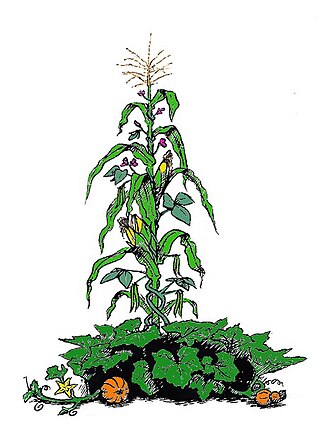
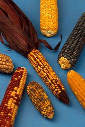
The Three Sisters are the three main agricultural crops of various indigenous peoples of Central and North America: squash, maize ("corn"), and climbing beans. In a technique known as companion planting, the maize and beans are often planted together in mounds formed by hilling soil around the base of the plants each year; squash is typically planted between the mounds. The cornstalk serves as a trellis for climbing beans, the beans fix nitrogen in their root nodules and stabilize the maize in high winds, and the wide leaves of the squash plant shade the ground, keeping the soil moist and helping prevent the establishment of weeds.

The Opata are an indigenous people in Mexico. Opata territory, the "Opatería" in Spanish, encompasses the mountainous northeast and central part of the state of Sonora, extending to near the border with the United States. Historically, they included several subtribes, including the Eudeve, Teguima, and Jova peoples.

<span class="mw-page-title-main">Hohokam Pima National Monument</span> Ancient Hohokam village in Arizona, United States

The Hohokam Pima National Monument is an ancient Hohokam village within the Gila River Indian Community, near present-day Sacaton, Arizona. The monument features the archaeological site Snaketown 30 miles (48 km) southeast of Phoenix, Arizona, designated a National Historic Landmark in 1964. The area was further protected by declaring it a national monument in 1972, and was listed on the National Register of Historic Places in 1974.

<span class="mw-page-title-main">Aridoamerica</span> Ecological region of North America

Aridoamerica denotes an ecological region spanning Northern Mexico and the Southwestern United States, defined by the presence of the culturally significant staple foodstuff Phaseolus acutifolius, a drought-resistant bean. Its dry, arid climate and geography stand in contrast to the verdant Mesoamerica of present-day central Mexico into Central America to the south and east, and the higher, milder "island" of Oasisamerica to the north. Aridoamerica overlaps with both.

<span class="mw-page-title-main">Oasisamerica</span> Pre-Columbian cultural region of North America

Oasisamerica is a cultural region of Indigenous peoples in North America. Their precontact cultures were predominantly agrarian, in contrast with neighboring tribes to the south in Aridoamerica. The region spans parts of Northwestern Mexico and Southwestern United States and can include most of Arizona and New Mexico; southern parts of Utah and Colorado; and northern parts of Sonora and Chihuahua. During some historical periods, it might have included parts of California and Texas as well.

Southwestern archaeology is a branch of archaeology concerned with the Southwestern United States and Northwestern Mexico. This region was first occupied by hunter-gatherers, and thousands of years later by advanced civilizations, such as the Ancestral Puebloans, the Hohokam, and the Mogollon.

<span class="mw-page-title-main">La Proveedora</span>

La Proveedora is an archeological site located some 15 kilometers west of the city of Caborca, Sonora, México, on the “La Proveedora” and “San José” hills within the “Rancho Puerto Blanco” Ejido, where most of these petroglyphs are located.

<span class="mw-page-title-main">Salado culture</span> Culture of the people of the Salt River area of Arizona

Salado culture, or Salado Horizon, was a human culture in the upper Salt River of the Tonto Basin in southeastern Arizona from approximately 1150 CE through the 15th century.

The history of Tucson, Arizona began thousands of years ago. Paleo-Indians practiced plant husbandry and hunted game in the Santa Cruz River Valley from 10,000 or earlier BCE. Archaic peoples began making irrigation canals, some of the first in North America, around 1,200 BCE. The Hohokam people lived in the Tucson area from around 450–1450 CE in a complex agricultural society.

Indigenous horticulture is practised in various ways across all inhabited continents. Indigenous refers to the native peoples of a given area and horticulture is the practice of small-scale intercropping.

<span class="mw-page-title-main">William E. Doolittle</span> American geographer

William E. Doolittle is an American geographer who is prominent among the fourth generation of the Berkeley School of Latin Americanist Geography. He is currently the Erich W. Zimmermann Regents Professor in Geography at the Department of Geography and the Environment at University of Texas at Austin. He specializes in landscapes and agricultural technology in the American Southwest and Mexico.

La Pintada is an archaeological site located some 60 kilometers south of the city of Hermosillo, Sonora, Mexico, within the "La Pintada" canyon, part of the "Sierra Libre", a small mountain massif of the coastal plains that extends throughout the Sonoran Desert.

<span class="mw-page-title-main">Early Basketmaker II Era</span> Ancient culture of the southwest United States

The Early Basketmaker II Era was the first Post-Archaic cultural period of Ancient Pueblo People. The era began with the cultivation of maize in the northern American southwest, although there was not a dependence upon agriculture until about 500 BCE. It is preceded by the Archaic-Early Basketmaker Era, and is followed by the Late Basketmaker II Era.

<i>Agave murpheyi</i> Species of flowering plant

Agave murpheyi is a species of agave. It is a succulent plant that is found growing only at a few dozen archaeological sites of the ancient Hohokam Indians in southern Arizona and northern Sonora, Mexico. In 1935 there were reported half a dozen sites and in 1970 only two were known. It appears to be a cultivar grown by the Hohokam for food and fiber. Its common names include Hohokam agave, Murphey agave, and Murphey's century plant.

<span class="mw-page-title-main">Agriculture in Mexico</span>

Agriculture in Mexico has been an important sector of the country’s economy historically and politically even though it now accounts for a very small percentage of Mexico’s GDP. Mexico is one of the cradles of agriculture with the Mesoamericans developing domesticated plants such as maize, beans, tomatoes, squash, cotton, vanilla, avocados, cacao, various kinds of spices, and more. Domestic turkeys and Muscovy ducks were the only domesticated fowl in the pre-Hispanic period and small dogs were raised for food. There were no large domesticated animals.

<span class="mw-page-title-main">Indigenous peoples of the North American Southwest</span> Regional culture of native peoples in southwestern North America

The Indigenous peoples of the North American Southwest are those in the current states of Colorado, Arizona, New Mexico, Utah, and Nevada in the western United States, and the states of Sonora and Chihuahua in northern Mexico. An often quoted statement from Erik Reed (1666) defined the Greater Southwest culture area as extending north to south from Durango, Mexico to Durango, Colorado and east to west from Las Vegas, Nevada to Las Vegas, New Mexico. Other names sometimes used to define the region include "American Southwest", "Northern Mexico", "Chichimeca", and "Oasisamerica/Aridoamerica". This region has long been occupied by hunter-gatherers and agricultural people.

References

  1. Merrill, William L. et al, "The Diffusion of Maize to the Southwestern United States and its Impact." Proceedings of the National Academy of Sciences of the United States of America. Vol. 106, No. 50 (December 15, 2009), pp. 21019-21020
  2. Merrill, et al, p. 21024
  3. "Marana History, "http://www.marana.com/DocumentCenter/Home/View/115 Archived 2012-12-17 at the Wayback Machine , accessed 30 June 2012
  4. Diehl, Michael W. "Early Agricultural Period Food Provisioning and Foraging." Archaeology Southwest, Vol. 23, NO. 1, Winter 2009, p. 12
  5. "Answers Encyclopedia." http://answers.encyclopedia.com/question/crop-fertilization-methods-were-used-early-native-american-farmers-514713.html Archived 2011-04-04 at the Wayback Machine , accessed 5 July 2012
  6. Periman, Richard D. "The influence of prehistoric Ancestral Puebloans cobble-mulch agricultural features on northern Rio Grande landscapes" http://www.fs.fed.us/rm/pubs_rm/rm_gtr272/rm_gtr272_181_188.pdf, accessed 1 July 2012
  7. "Top 10 Discoveries of 2009 Early Irrigators Tucson, Arizona." http://www.archaeology.org/1001/topten/arizona.html, accessed 3 June 2012
  8. "Ina dig reveals early irrigation practices." Pima Pinal 12 May 2009
  9. Doolittle, William E. "Agriculture in North America on the Eve of Contact: A Reassessment" Annals of the Association of American Geographers, 82(3), 1992, p. 389
  10. "Immigrants and Population Collapse in the Southern Southwest" Archaeology Southwest, Vol 22, No. 4, Fall 2008, p. 1
  11. Doolittle, p. 389-390
  12. Doolittle, p. 389
  13. Merrill et al, P. 21,024
  14. "What is a Trincheras Site?" Arizona State Museum, University of Arizona. http://www.statemuseum.arizona.edu/exhibtis/heisey/heisey2.shtml%5B%5D, accessed 1 July 2012
  15. Doolittle, William E. Cultivated Landscapes of Native North America Oxford: Oxford U Press, 2000, p. 257
  16. Minnis, Paul E., Whalen, Michael E., and Howell, R. Emerson. "Fields of Power: Upland Farming in the Prehispanic Casas Grandes Polity, Chihuahua, Mexico." American Antiquity, 71(4) 2006, pp. 709, 712
  17. Periman, p. 182
  18. Gregoris, Linda M. "The Hohokam." sonorensis, Vol 16, No. 1, Spring 1996, http://www.desertmuseum.org/members/sonorensis/week8.php, accessed 1 June 2012
  19. Fish, Suzanne K. "Hohokam Impacts on Sonoran Desert Environment" in Imperfect Balance: Landscape Transformations in the PreColumbian Americas ed. by David L. Lentz, New York: Columbia U Press, 2000, p.264
  20. Periman, p. 182
  21. Riley, Carroll L. The Frontier People: the Greater Southwest in the Protohistoric Period. Albuquerque: U of NM Press, 1987, p. 298
  22. Worster, Donald. Rivers of Empire: Water, and Aridity and the Growth of the American West New York: Pantheon Books, 1985, p. 33-34
  23. Nabhan, Gary Paul. Gathering the Desert Tucson: U of AZ Press, 1990, p. 107-116