
Stormwater, also written storm water, is water that originates from precipitation (storm), including heavy rain and meltwater from hail and snow. Stormwater can soak into the soil (infiltrate) and become groundwater, be stored on depressed land surface in ponds and puddles, evaporate back into the atmosphere, or contribute to surface runoff. Most runoff is conveyed directly as surface water to nearby streams, rivers or other large water bodies without treatment.
Water quality refers to the chemical, physical, and biological characteristics of water based on the standards of its usage. It is most frequently used by reference to a set of standards against which compliance, generally achieved through treatment of the water, can be assessed. The most common standards used to monitor and assess water quality convey the health of ecosystems, safety of human contact, extent of water pollution and condition of drinking water. Water quality has a significant impact on water supply and oftentimes determines supply options.

Water pollution is the contamination of water bodies, usually as a result of human activities, so that it negatively affects its uses. Water bodies include lakes, rivers, oceans, aquifers, reservoirs and groundwater. Water pollution results when contaminants mix with these water bodies. Contaminants can come from one of four main sources: sewage discharges, industrial activities, agricultural activities, and urban runoff including stormwater. Water pollution is either surface water pollution or groundwater pollution. This form of pollution can lead to many problems, such as the degradation of aquatic ecosystems or spreading water-borne diseases when people use polluted water for drinking or irrigation. Another problem is that water pollution reduces the ecosystem services that the water resource would otherwise provide.

The Clean Water Act (CWA) is the primary federal law in the United States governing water pollution. Its objective is to restore and maintain the chemical, physical, and biological integrity of the nation's waters; recognizing the responsibilities of the states in addressing pollution and providing assistance to states to do so, including funding for publicly owned treatment works for the improvement of wastewater treatment; and maintaining the integrity of wetlands.

The Monocacy River is a free-flowing left tributary to the Potomac River, which empties into the Atlantic Ocean via the Chesapeake Bay. The river is 58.5 miles (94.1 km) long, with a drainage area of about 970 square miles (2,500 km2). It is the largest Maryland tributary to the Potomac.

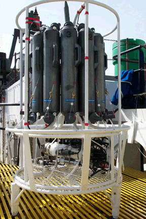
Agricultural wastewater treatment is a farm management agenda for controlling pollution from confined animal operations and from surface runoff that may be contaminated by chemicals in fertilizer, pesticides, animal slurry, crop residues or irrigation water. Agricultural wastewater treatment is required for continuous confined animal operations like milk and egg production. It may be performed in plants using mechanized treatment units similar to those used for industrial wastewater. Where land is available for ponds, settling basins and facultative lagoons may have lower operational costs for seasonal use conditions from breeding or harvest cycles. Animal slurries are usually treated by containment in anaerobic lagoons before disposal by spray or trickle application to grassland. Constructed wetlands are sometimes used to facilitate treatment of animal wastes.

Nonpoint source (NPS) pollution refers to diffuse contamination of water or air that does not originate from a single discrete source. This type of pollution is often the cumulative effect of small amounts of contaminants gathered from a large area. It is in contrast to point source pollution which results from a single source. Nonpoint source pollution generally results from land runoff, precipitation, atmospheric deposition, drainage, seepage, or hydrological modification where tracing pollution back to a single source is difficult. Nonpoint source water pollution affects a water body from sources such as polluted runoff from agricultural areas draining into a river, or wind-borne debris blowing out to sea. Nonpoint source air pollution affects air quality, from sources such as smokestacks or car tailpipes. Although these pollutants have originated from a point source, the long-range transport ability and multiple sources of the pollutant make it a nonpoint source of pollution; if the discharges were to occur to a body of water or into the atmosphere at a single location, the pollution would be single-point.

Surface runoff is the unconfined flow of water over the ground surface, in contrast to channel runoff. It occurs when excess rainwater, stormwater, meltwater, or other sources, can no longer sufficiently rapidly infiltrate in the soil. This can occur when the soil is saturated by water to its full capacity, and the rain arrives more quickly than the soil can absorb it. Surface runoff often occurs because impervious areas do not allow water to soak into the ground. Furthermore, runoff can occur either through natural or human-made processes.
The DSSAM Model is a computer simulation developed for the Truckee River to analyze water quality impacts from land use and wastewater management decisions in the Truckee River Basin. This area includes the cities of Reno and Sparks, Nevada as well as the Lake Tahoe Basin. The model is historically and alternatively called the Earth Metrics Truckee River Model. Since original development in 1984-1986 under contract to the U.S. Environmental Protection Agency (EPA), the model has been refined and successive versions have been dubbed DSSAM II and DSSAM III. This hydrology transport model is based upon a pollutant loading metric called Total maximum daily load (TMDL). The success of this flagship model contributed to the Agency's broadened commitment to the use of the underlying TMDL protocol in its national policy for management of most river systems in the United States.

An hydrological transport model is a mathematical model used to simulate the flow of rivers, streams, groundwater movement or drainage front displacement, and calculate water quality parameters. These models generally came into use in the 1960s and 1970s when demand for numerical forecasting of water quality and drainage was driven by environmental legislation, and at a similar time widespread access to significant computer power became available. Much of the original model development took place in the United States and United Kingdom, but today these models are refined and used worldwide.

Best management practices (BMPs) is a term used in the United States and Canada to describe a type of water pollution control. Historically the term has referred to auxiliary pollution controls in the fields of industrial wastewater control and municipal sewage control, while in stormwater management and wetland management, BMPs may refer to a principal control or treatment technique as well.

Urban runoff is surface runoff of rainwater, landscape irrigation, and car washing created by urbanization. Impervious surfaces are constructed during land development. During rain, storms, and other precipitation events, these surfaces, along with rooftops, carry polluted stormwater to storm drains, instead of allowing the water to percolate through soil. This causes lowering of the water table and flooding since the amount of water that remains on the surface is greater. Most municipal storm sewer systems discharge untreated stormwater to streams, rivers, and bays. This excess water can also make its way into people's properties through basement backups and seepage through building wall and floors.

Assimilative capacity is the ability for pollutants to be absorbed by an environment without detrimental effects to the environment or those who use of it. Natural absorption into an environment is achieved through dilution, dispersion and removal through chemical or biological processes. The term assimilative capacity has been used interchangeably with environmental capacity, receiving capacity and absorptive capacity. It is used as a measurement perimeter in hydrology, meteorology and pedology for a variety of environments examples consist of: lakes, rivers, oceans, cities and soils. Assimilative capacity is a subjective measurement that is quantified by governments and institutions such as Environmental Protection Agency (EPA) of environments into guidelines. Using assimilative capacity as a guideline can help the allocation of resources while reducing the impact on organisms in an environment. This concept is paired with carrying capacity in order to facilitate sustainable development of city regions. Assimilative capacity has been critiqued as to its effectiveness due to ambiguity in its definition that can confuses readers and false assumptions that a small amount of pollutants has no harmful effect on an environment.

Nutrient pollution, a form of water pollution, refers to contamination by excessive inputs of nutrients. It is a primary cause of eutrophication of surface waters, in which excess nutrients, usually nitrogen or phosphorus, stimulate algal growth. Sources of nutrient pollution include surface runoff from farm fields and pastures, discharges from septic tanks and feedlots, and emissions from combustion. Raw sewage is a large contributor to cultural eutrophication since sewage is high in nutrients. Releasing raw sewage into a large water body is referred to as sewage dumping, and still occurs all over the world. Excess reactive nitrogen compounds in the environment are associated with many large-scale environmental concerns. These include eutrophication of surface waters, harmful algal blooms, hypoxia, acid rain, nitrogen saturation in forests, and climate change.

Water quality laws govern the protection of water resources for human health and the environment. Water quality laws are legal standards or requirements governing water quality, that is, the concentrations of water pollutants in some regulated volume of water. Such standards are generally expressed as levels of a specific water pollutants that are deemed acceptable in the water volume, and are generally designed relative to the water's intended use - whether for human consumption, industrial or domestic use, recreation, or as aquatic habitat. Additionally, these laws provide regulations on the alteration of the chemical, physical, radiological, and biological characteristics of water resources. Regulatory efforts may include identifying and categorizing water pollutants, dictating acceptable pollutant concentrations in water resources, and limiting pollutant discharges from effluent sources. Regulatory areas include sewage treatment and disposal, industrial and agricultural waste water management, and control of surface runoff from construction sites and urban environments. Water quality laws provides the foundation for regulations in water standards, monitoring, required inspections and permits, and enforcement. These laws may be modified to meet current needs and priorities.

Water pollution in the United States is a growing problem that became critical in the 19th century with the development of mechanized agriculture, mining, and industry, although laws and regulations introduced in the late 20th century have improved water quality in many water bodies. Extensive industrialization and rapid urban growth exacerbated water pollution as a lack of regulation allowed for discharges of sewage, toxic chemicals, nutrients and other pollutants into surface water.
Water quality modeling involves water quality based data using mathematical simulation techniques. Water quality modeling helps people understand the eminence of water quality issues and models provide evidence for policy makers to make decisions in order to properly mitigate water. Water quality modeling also helps determine correlations to constituent sources and water quality along with identifying information gaps. Due to the increase in freshwater usage among people, water quality modeling is especially relevant both in a local level and global level. In order to understand and predict the changes over time in water scarcity, climate change, and the economic factor of water resources, water quality models would need sufficient data by including water bodies from both local and global levels.
Nonpoint source (NPS) water pollution regulations are environmental regulations that restrict or limit water pollution from diffuse or nonpoint effluent sources such as polluted runoff from agricultural areas in a river catchments or wind-borne debris blowing out to sea. In the United States, governments have taken a number of legal and regulatory approaches to controlling NPS effluent. Nonpoint water pollution sources include, for example, leakage from underground storage tanks, storm water runoff, atmospheric deposition of contaminants, and golf course, agricultural, and forestry runoff.

Point source water pollution comes from discrete conveyances and alters the chemical, biological, and physical characteristics of water. In the United States, it is largely regulated by the Clean Water Act (CWA). Among other things, the Act requires dischargers to obtain a National Pollutant Discharge Elimination System (NPDES) permit to legally discharge pollutants into a water body. However, point source pollution remains an issue in some water bodies, due to some limitations of the Act. Consequently, other regulatory approaches have emerged, such as water quality trading and voluntary community-level efforts.
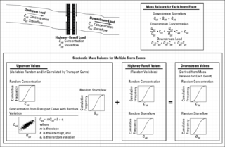
The stochastic empirical loading and dilution model (SELDM) is a stormwater quality model. SELDM is designed to transform complex scientific data into meaningful information about the risk of adverse effects of runoff on receiving waters, the potential need for mitigation measures, and the potential effectiveness of such management measures for reducing these risks. The U.S. Geological Survey developed SELDM in cooperation with the Federal Highway Administration to help develop planning-level estimates of event mean concentrations, flows, and loads in stormwater from a site of interest and from an upstream basin. SELDM uses information about a highway site, the associated receiving-water basin, precipitation events, stormflow, water quality, and the performance of mitigation measures to produce a stochastic population of runoff-quality variables. Although SELDM is, nominally, a highway runoff model is can be used to estimate flows concentrations and loads of runoff-quality constituents from other land use areas as well. SELDM was developed by the U.S. Geological Survey so the model, source code, and all related documentation are provided free of any copyright restrictions according to U.S. copyright laws and the USGS Software User Rights Notice. SELDM is widely used to assess the potential effect of runoff from highways, bridges, and developed areas on receiving-water quality with and without the use of mitigation measures. Stormwater practitioners evaluating highway runoff commonly use data from the Highway Runoff Database (HRDB) with SELDM to assess the risks for adverse effects of runoff on receiving waters.
