
Lincoln is a town in Grafton County, New Hampshire, United States. It is the second-largest town by area in New Hampshire. The population was 1,631 at the 2020 census. The town is home to the New Hampshire Highland Games and to a portion of Franconia Notch State Park. Set in the White Mountains, large portions of the town are within the White Mountain National Forest. The Appalachian Trail crosses the western and northeastern parts of the town. Lincoln is the location of Loon Mountain Ski Resort and associated recreation-centered development.

Grafton County is a county in the U.S. state of New Hampshire. As of the 2020 census, the population was 91,118. Its county seat is the town of Haverhill. In 1972, the county courthouse and other offices were moved from Woodsville, a larger village within the town of Haverhill, to North Haverhill.

The White Mountains are a mountain range covering about a quarter of the state of New Hampshire and a small portion of western Maine in the United States. They are a subrange of the northern Appalachian Mountains and the most rugged mountains in New England. Several of the higher peaks contain an Alpine tundra. The range is heavily visited due to its proximity to Boston, New York City, and Montreal.
Littleton is a census-designated place (CDP) and the main village in the town of Littleton in Grafton County, New Hampshire, United States. The population of the CDP was 4,467 at the 2020 census, out of 6,005 in the entire town.

U.S. Route 302 is an east–west spur of U.S. Route 2 in northern New England in the United States. It currently runs 171 miles (275 km) from Montpelier, Vermont, beginning at US 2, to Portland, Maine, at U.S. Route 1. It passes through the states of Vermont, New Hampshire and Maine.

The White Mountain National Forest (WMNF) is a federally managed forest contained within the White Mountains in the northeastern United States. It was established in 1918 as a result of the Weeks Act of 1911; federal acquisition of land had already begun in 1914. It has a total area of 750,852 acres (303,859 ha). Most of the WMNF is in New Hampshire; a small part is in the neighboring state of Maine. Conservationist and community activist Katherine Sleeper Walden was instrumental in securing at-risk land for the forest, including thousands of acres in the region surrounding the locally famous Bowl near Wonalancet.

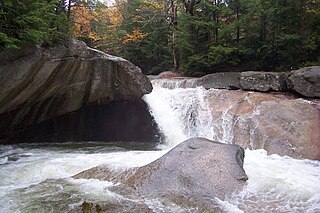
Franconia Notch State Park is a public recreation area and nature preserve that straddles eight miles (13 km) of Interstate 93 as it passes through Franconia Notch, a mountain pass between the Kinsman Range and Franconia Range in the White Mountains of northern New Hampshire, United States. The northern part of the park, including Cannon Mountain and Echo and Profile lakes, is in the town of Franconia, and the southern part, including Lonesome Lake and the Flume, is in Lincoln. Attractions in the state park include the Flume Gorge and visitor center, the Old Man of the Mountain historical site, fishing in Echo Lake and Profile Lake, and miles of hiking, biking and ski trails.
The Pemigewasset River, known locally as "The Pemi", is a river in the state of New Hampshire, the United States. It is 65.0 miles (104.6 km) in length and drains approximately 1,021 square miles (2,644 km2). The name "Pemigewasset" comes from the Abenaki word bemijijoasek [bəmidzidzoasək], meaning "where side (entering) current is".

New Hampshire Route 16 is a 154.771-mile (249.080 km), north–south state highway in New Hampshire, United States, the main road connecting the Seacoast region to the Lakes Region and the White Mountains. Much of its length is close to the border with Maine. The section from Portsmouth to Milton is a controlled-access toll highway known as the Spaulding Turnpike. Between Milton and Chocorua, and between Conway and Glen, it is known as the White Mountain Highway. It is known as Chocorua Mountain Highway between Chocorua and Conway and various other local names before crossing into Maine about 20 miles (32 km) south of the Canadian border. Portions of NH 16 run concurrent with U.S. Route 4 (US 4), US 202, NH 25, and US 302, and US 2.

New Hampshire Route 18 is a 20.116-mile-long (32.374 km) state highway in northwestern New Hampshire. It is a local road serving Franconia, Bethlehem, and Littleton, New Hampshire, which I-93 bypasses. Its northern extension, Vermont Route 18, continues northward from the Connecticut River to St. Johnsbury, Vermont. NH 18 closely parallels I-93 for its entire length and has several interchanges with the Interstate highway.

New Hampshire Route 112 is a 56.39-mile-long (90.75 km) east–west state highway in northern New Hampshire. The highway winds across the state, connecting Bath to Conway through the heart of the scenic and mountainous White Mountain National Forest.

New Hampshire Route 116 is a 48.605-mile-long (78.222 km) north-south state highway in northern New Hampshire, United States. NH 116 is a scenic rural highway stretching from Haverhill, which lies along the Connecticut River, to Jefferson, in the White Mountains Region. The southern terminus is at NH 10 in the village of North Haverhill and the northern terminus is at U.S. Route 2, near the Santa's Village amusement park. Major intersections include Interstate 93, U.S. Route 3, and U.S. Route 302.

New Hampshire Route 142 is a 19.688-mile-long (31.685 km) north–south state highway in northern New Hampshire. The highway runs between Franconia in the White Mountains Region to Dalton in the upper Connecticut River valley.

White Mountain art is the body of work created during the 19th century by over four hundred artists who painted landscape scenes of the White Mountains of New Hampshire in order to promote the region and, consequently, sell their works of art.

Daniel Webster Highway is the name for several sections of U.S. Route 3 in New Hampshire. The highway is named after 19th century statesman Daniel Webster, a New Hampshire native.

The East Branch of the Pemigewasset River is a 15.8-mile-long (25.4 km) river located in the White Mountains of New Hampshire in the United States. It is a tributary of the Pemigewasset River, part of the Merrimack River watershed.

Echo Lake is a 38.2-acre (15.5 ha) water body located in Franconia Notch in the White Mountains of the U.S state of New Hampshire, at the foot of Cannon Mountain. The lake is in the Connecticut River watershed, near the height of land in Franconia Notch; water from the lake's outlet flows north via Lafayette Brook to the Gale River, then the Ammonoosuc River, and finally the Connecticut River to Long Island Sound, an arm of the Atlantic Ocean.
The Twin State Mutual Aid Fire Association is the dispatch center and coordinating agency for fire and emergency medical services operations in 23 towns in Grafton County, New Hampshire, and Orange County and Caledonia County in Vermont. Dispatching duties are handled by the Grafton County Sheriff's Department stationed in North Haverhill, New Hampshire.

Northway Bank, is a community bank located in New Hampshire. It was established in 1997 when the Berlin City Bank and the Pemigewasset National Bank merged, creating Northway Financial and adopting the name Northway Bank in 2005. Today, it is New Hampshire's largest independent commercial bank and the top-ranking SBA lender in the state.
