Ömnögovi, Uvs

Last updated
Ömnögovi District
Өмнөговь сум
ᠡᠮᠦᠨᠡᠭᠣᠪᠢᠰᠤᠮᠤ
District
Mongolia location map 2.svg
Red pog.svg
Ömnögovi District
Coordinates: 49°6′23″N91°43′7″E / 49.10639°N 91.71861°E / 49.10639; 91.71861 Coordinates: 49°6′23″N91°43′7″E / 49.10639°N 91.71861°E / 49.10639; 91.71861
Country Mongolia
Province Uvs Province
Time zone UTC + 7 (UTC+7)

Ömnögovi (Mongolian : Өмнөговь, translit. Ömnögowĭ) is a sum (district) of Uvs Province in western Mongolia.

Mongolian language language spoken in Mongolia

The Mongolian languageMoŋɣol kele; in Mongolian Cyrillic: монгол хэл, mongol khel) is the official language of Mongolia and both the most widely-spoken and best-known member of the Mongolic language family. The number of speakers across all its dialects may be 5.2 million, including the vast majority of the residents of Mongolia and many of the Mongolian residents of the Inner Mongolia Autonomous Region. In Mongolia, the Khalkha dialect, written in Cyrillic, is predominant, while in Inner Mongolia, the language is dialectally more diverse and is written in the traditional Mongolian script. In the discussion of grammar to follow, the variety of Mongolian treated is Standard Khalkha Mongolian, but much of what is to be said is also valid for vernacular (spoken) Khalkha and for other Mongolian dialects, especially Chakhar.

Uvs Province Province in Mongolia

Uvs is one of the 21 aimags (provinces) of Mongolia. It is located in the west of the country, 1,336 kilometres or 830 miles away from the national capital Ulaanbaatar. Its capital is Ulaangom which lies 936 metres or 3,070 feet above sea level.

Part of the sum is desert, that has sand dunes.

Climate

Ömnögovi has a semi-arid climate (Köppen climate classification BSk) with warm summers and severely cold winters. The average minimum temperature in January is −28.3 °C (−18.9 °F), and temperatures as low as −45.5 °C (−49.9 °F) have been recorded. Most precipitation falls in the summer as rain, with some snow in the adjacent months of May and September. Winters are very dry.

Semi-arid climate climat with precipitation below potential evapotranspiration

A semi-arid climate or steppe climate is the climate of a region that receives precipitation below potential evapotranspiration, but not as low as a desert climate. There are different kinds of semi-arid climates, depending on variables such as temperature, and they give rise to different biomes.

Köppen climate classification widely used climate classification system

The Köppen climate classification is one of the most widely used climate classification systems. It was first published by the Russian climatologist Wladimir Köppen (1846–1940) in 1884, with several later modifications by Köppen, notably in 1918 and 1936. Later, the climatologist Rudolf Geiger introduced some changes to the classification system, which is thus sometimes called the Köppen–Geiger climate classification system.

Climate data for Ömnögovi
MonthJanFebMarAprMayJunJulAugSepOctNovDecYear
Record high °C (°F) 3.2
(37.8)
8.2
(46.8)
17.5
(63.5)
24.3
(75.7)
28.3
(82.9)
31.3
(88.3)
33.6
(92.5)
38.9
(102)
29.7
(85.5)
24.4
(75.9)
11.9
(53.4)
9.2
(48.6)
38.9
(102)
Average high °C (°F) −15.2
(4.6)
−11.1
(12)
−0.4
(31.3)
8.6
(47.5)
16.7
(62.1)
21.6
(70.9)
22.5
(72.5)
21.0
(69.8)
15.3
(59.5)
6.9
(44.4)
−3.8
(25.2)
−13.1
(8.4)
5.8
(42.3)
Daily mean °C (°F) −22.6
(−8.7)
−19.5
(−3.1)
−8.6
(16.5)
1.0
(33.8)
9.5
(49.1)
15.0
(59)
16.2
(61.2)
14.2
(57.6)
7.9
(46.2)
−0.6
(30.9)
−10.9
(12.4)
−20.3
(−4.5)
−1.6
(29.2)
Average low °C (°F) −28.4
(−19.1)
−26.0
(−14.8)
−16.0
(3.2)
−6.1
(21)
2.2
(36)
8.2
(46.8)
10.5
(50.9)
8.2
(46.8)
1.2
(34.2)
−6.3
(20.7)
−16.4
(2.5)
−25.1
(−13.2)
−7.8
(17.9)
Record low °C (°F) −45.5
(−49.9)
−42.3
(−44.1)
−35.6
(−32.1)
−23.1
(−9.6)
−16.9
(1.6)
−3.0
(26.6)
1.5
(34.7)
−1.8
(28.8)
−18.5
(−1.3)
−22.0
(−7.6)
−31.8
(−25.2)
−42.8
(−45)
−45.5
(−49.9)
Average precipitation mm (inches) 0.7
(0.028)
0.5
(0.02)
1.9
(0.075)
4.3
(0.169)
6.8
(0.268)
24.9
(0.98)
44.6
(1.756)
27.0
(1.063)
12.2
(0.48)
3.0
(0.118)
1.3
(0.051)
1.4
(0.055)
128.6
(5.063)
Average precipitation days (≥ 1.0 mm) 0.1 0.3 0.6 1.0 1.6 4.3 4.2 4.5 2.1 0.5 0.3 0.5 20
Source: NOAA (1963-1990) [1]

Related Research Articles

Subarctic climate

The subarctic climate is a climate characterised by long, usually very cold winters, and short, cool to mild summers. It is found on large landmasses, away from the moderating effects of an ocean, generally at latitudes from 50° to 70°N poleward of the humid continental climates. These climates represent Köppen climate classification Dfc, Dwc, Dsc, Dfd, Dwd and Dsd. In very small areas at high altitudes around the Mediterranean Basin, Iran, Kyrgyzstan, Tajikistan, Turkey, Alaska and other parts of the northwestern United States and Russian South-Eastern regions the climate is classified as Dsc with a dry summer climate, such as in Seneca, Oregon or Atlin, British Columbia.

Khovd Province Province in Mongolia

Khovd is one of the 21 aimags (provinces) of Mongolia, located in the west of the country. Its capital is also named Khovd.

Choibalsan (city) District in Dornod Province, Mongolia

Choibalsan is the fourth-largest city in Mongolia after Ulaanbaatar, Darkhan, and Erdenet. The name of the city was Bayan Tümen until 1941, when it was renamed after the communist leader Khorloogiin Choibalsan. It is the capital of the province of Dornod. The city administrative unit's official name is Kherlen sum, with area of 281 square kilometres or 108 square miles. It is situated at the Kherlen River, at an elevation of 747 metres or 2,451 feet above sea level.

Dalanzadgad District in Ömnögovi Province, Mongolia

Dalanzadgad is the capital of Ömnögovi Aimag in Mongolia. It is located 540 kilometers (340 mi) south of the national capital Ulaanbaatar. The altitude of the city center is 1,470 meters.

Humid continental climate Category in the Köppen climate classification system

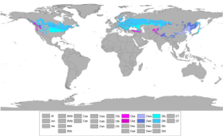
A humid continental climate is a climatic region defined by Russo-German climatologist Wladimir Köppen in 1900, typified by large seasonal temperature differences, with warm to hot summers and cold winters. Precipitation is usually distributed throughout the year. The definition of this climate regarding temperature is as follows: the mean temperature of the coldest month must be below −3 °C (26.6 °F) and there must be at least four months whose mean temperatures are at or above 10 °C (50 °F). In addition, the location in question must not be semi-arid or arid. The Dfb, Dwb and Dsb subtypes are also known as hemiboreal.

Renchinlkhümbe District in Khövsgöl Province, Mongolia

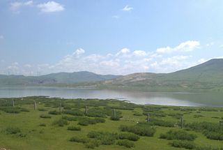
Renchinlkhümbe is a sum of Khövsgöl aimag. The area is about 8,850 square kilometres (3,420 sq mi), of which 2,910 square kilometres (1,120 sq mi) are pasture and 35% are forest. In 2000, the sum had 4284 inhabitants, mainly Darkhad. The sum center, officially named Zöölön, is located 265 kilometres (165 mi) north of Mörön and 998 kilometres (620 mi) from Ulaanbaatar.

Tsetserleg (city) District in Arkhangai Province, Mongolia

Tsetserleg, also transliterated as Cecerleg is the capital of Arkhangai Aimag (province) in Mongolia. It lies on the northeastern slopes of the Khangai Mountains, 360 miles (600 km) southwest of Ulaanbaatar. It has a population of 16,553, 16,618, 16,300.

Ulanhot County-level city in Inner Mongolia, Peoples Republic of China

Ulanhot, formerly known as Wangin Süm, alternatively Wang-un Süme, Ulayanqota in Classical Mongolian, and Wangyehmiao or Wangyemiao in Chinese prior to 1947, is a county-level city and the administrative center of Hinggan League in the East of Inner Mongolia autonomous region. Between the years 1947 and 1950, Ulanhot was the capital of Inner Mongolia Region. In 1950, the capital moved to Zhangjiakou and then again in 1952 it moved to Hohhot, which remains the capital to this day.

Baruunturuun District in Mongolia

Baruunturuun is a sum in Uvs Province of Mongolia.

Galuut District in Bayankhongor Province, Mongolia

Galuut is a sum (district) of Bayankhongor Province in southern Mongolia.

Tsogt-Ovoo, Ömnögovi District in Ömnögovi Province, Mongolia

Tsogt-Ovoo is a sum (district) of Ömnögovi Province in southern Mongolia. As of 2009 the population of the sum was 1,666, including 619 in the sum center. The area of the sum is 6,526 square kilometres (2,520 sq mi) and its population density is 0.26 people/km².

Tosontsengel, Zavkhan District in Zavkhan Province, Mongolia

Tosontsengel is a sum of Zavkhan Province (aimag) in western Mongolia. It is the largest sum and sum centre in Zavkhan aimag after its capital.

Dulan County County in Qinghai, Peoples Republic of China

Dulan County is a county of east-central Qinghai province, China. It is under the administration of Haixi Mongol and Tibetan Autonomous Prefecture.

Darhan Muminggan United Banner Banner in Inner Mongolia, Peoples Republic of China

Darhan Muminggan United Banner is a banner of west-central Inner Mongolia, People's Republic of China. It is under the administration of Baotou City, 125 kilometres (78 mi) to the south-southwest.

Jarud Banner Banner in Inner Mongolia, Peoples Republic of China

Jarud Banner is a banner of eastern Inner Mongolia, People's Republic of China. It is under the administration of Tongliao City, 150 kilometres (93 mi), and the China National Highway 304 passes through the area.

Genhe County-level city in Inner Mongolia, Peoples Republic of China

Genhe (Gegengol), formerly Ergun Left Banner or Ergun Zuoqi, is a city in the far northeast of Inner Mongolia, People's Republic of China. It is administratively a county-level city of Hulunbuir City.

Arxan County-level city in Inner Mongolia, Peoples Republic of China

Arxan is a county-level city in the Hinggan League of northeastern Inner Mongolia in the People's Republic of China.

Abag Banner Banner in Inner Mongolia, Peoples Republic of China

Abag Banner is a county of Inner Mongolia, People's Republic of China. It is under the administration of Xilin Gol League. Abag Mongols live here. The local dialect has variously been classified as Chakhar or Khalkha.

West Ujimqin Banner Banner in Inner Mongolia, Peoples Republic of China

West Ujimqin Banner is a banner of Inner Mongolia, People's Republic of China. It is under the administration of Xilin Gol League.

References