
Kalasin is a town in northeast Thailand, the capital of Kalasin Province. As of 2015, it has a population of 34,429 It covers the whole tambon Kalasin of the Mueang Kalasin District, an area of 16.96 km2. Kalasin lies 513 road kilometers north-northeast of Bangkok.
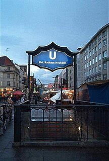
Rathaus Neukölln is a Berlin U-Bahn station located on the U 7. It was built in 1926 by A. Grenander. The platform was extended in 1968. In 1989 a lift was built in. It was the first subway station in Neukölln that was handicap-accessible. The next stop is Karl-Marx-Straße.
Tögrög is a sum (district) of Övörkhangai Province in south-central Mongolia.
Kołatki is a village in the administrative district of Gmina Chodecz, within Włocławek County, Kuyavian-Pomeranian Voivodeship, in north-central Poland.

Ratwica is a village in the administrative district of Gmina Biłgoraj, within Biłgoraj County, Lublin Voivodeship, in eastern Poland. It lies approximately 7 kilometres (4 mi) east of Biłgoraj and 81 km (50 mi) south of the regional capital Lublin.
Lipiny is a village in the administrative district of Gmina Dziadkowice, within Siemiatycze County, Podlaskie Voivodeship, in north-eastern Poland. It lies approximately 4 kilometres (2 mi) west of Dziadkowice, 13 km (8 mi) north of Siemiatycze, and 68 km (42 mi) south of the regional capital Białystok.
Żuki is a village in the administrative district of Gmina Sokółka, within Sokółka County, Podlaskie Voivodeship, in north-eastern Poland, close to the border with Belarus. It lies approximately 7 kilometres (4 mi) north-west of Sokółka and 41 km (25 mi) north-east of the regional capital Białystok.
Jaczno is a village in the administrative district of Gmina Dąbrowa Białostocka, within Sokółka County, Podlaskie Voivodeship, in north-eastern Poland. It lies approximately 6 kilometres (4 mi) east of Dąbrowa Białostocka, 28 km (17 mi) north of Sokółka, and 62 km (39 mi) north of the regional capital Białystok.
Drzewoszki Małe is a village in the administrative district of Gmina Żychlin, within Kutno County, Łódź Voivodeship, in central Poland.
Czestków-Osiedle is a village in the administrative district of Gmina Buczek, within Łask County, Łódź Voivodeship, in central Poland.
Karolów is a village in the administrative district of Gmina Sienno, within Lipsko County, Masovian Voivodeship, in east-central Poland.
Ostrów-Kania is a village in the administrative district of Gmina Dębe Wielkie, within Mińsk County, Masovian Voivodeship, in east-central Poland. It lies approximately 2 kilometres (1 mi) north-west of Dębe Wielkie, 10 km (6 mi) west of Mińsk Mazowiecki, and 30 km (19 mi) east of Warsaw.
Biała is a village in the administrative district of Gmina Trzcianka, within Czarnków-Trzcianka County, Greater Poland Voivodeship, in west-central Poland. It lies approximately 5 kilometres (3 mi) east of Trzcianka, 17 km (11 mi) north of Czarnków, and 76 km (47 mi) north of the regional capital Poznań.
Zakrzewek is a village in the administrative district of Gmina Sompolno, within Konin County, Greater Poland Voivodeship, in west-central Poland.
Pagórki is a village in the administrative district of Gmina Wierzbinek, within Konin County, Greater Poland Voivodeship, in west-central Poland.
Proboszczowice is a village in the administrative district of Gmina Toszek, within Gliwice County, Silesian Voivodeship, in southern Poland. It lies approximately 8 kilometres (5 mi) west of Toszek, 25 km (16 mi) north-west of Gliwice, and 47 km (29 mi) north-west of the regional capital Katowice.
Malczkówko is a village in the administrative district of Gmina Potęgowo, within Słupsk County, Pomeranian Voivodeship, in northern Poland. It lies approximately 10 kilometres (6 mi) south-west of Potęgowo, 22 km (14 mi) east of Słupsk, and 84 km (52 mi) west of the regional capital Gdańsk.

Reszki is a village in the administrative district of Gmina Wejherowo, within Wejherowo County, Pomeranian Voivodeship, in northern Poland. It lies approximately 9 kilometres (6 mi) south-east of Wejherowo and 28 km (17 mi) north-west of the regional capital Gdańsk.
Bajorki is a settlement in the administrative district of Gmina Srokowo, within Kętrzyn County, Warmian-Masurian Voivodeship, in northern Poland, close to the border with the Kaliningrad Oblast of Russia.
Borzyszkowo is a village in the administrative district of Gmina Darłowo, within Sławno County, West Pomeranian Voivodeship, in north-western Poland. It lies approximately 9 kilometres (6 mi) east of Darłowo, 12 km (7 mi) north-west of Sławno, and 172 km (107 mi) north-east of the regional capital Szczecin.


