
Ministrówka is a village in the administrative district of Gmina Miączyn, within Zamość County, Lublin Voivodeship, in eastern Poland. It lies approximately 2 kilometres north-west of Miączyn, 17 km east of Zamość, and 85 km south-east of the regional capital Lublin.
Zawalów is a village in the administrative district of Gmina Miączyn, within Zamość County, Lublin Voivodeship, in eastern Poland. It lies approximately 21 kilometres (13 mi) east of Zamość and 89 km (55 mi) south-east of the regional capital Lublin.
Horyszów Polski is a village in the administrative district of Gmina Sitno, within Zamość County, Lublin Voivodeship, in eastern Poland. It lies approximately 4 kilometres (2 mi) south-east of Sitno, 12 km (7 mi) east of Zamość, and 82 km (51 mi) south-east of the regional capital Lublin.
Sitno is a village in Zamość County, Lublin Voivodeship, in eastern Poland. It is the seat of the gmina called Gmina Sitno. It lies approximately 9 kilometres (6 mi) north-east of Zamość and 79 km (49 mi) south-east of the regional capital Lublin.
Podwysokie is a village in the administrative district of Gmina Skierbieszów, within Zamość County, Lublin Voivodeship, in eastern Poland. It lies approximately 6 kilometres (4 mi) north-east of Skierbieszów, 22 km (14 mi) north-east of Zamość, and 72 km (45 mi) south-east of the regional capital Lublin.
Sady is a village in the administrative district of Gmina Skierbieszów, within Zamość County, Lublin Voivodeship, in eastern Poland. It lies approximately 2 kilometres (1 mi) east of Skierbieszów, 17 km (11 mi) north-east of Zamość, and 73 km (45 mi) south-east of the regional capital Lublin.
Suchodębie is a village in the administrative district of Gmina Skierbieszów, within Zamość County, Lublin Voivodeship, in eastern Poland. It lies approximately 5 kilometres (3 mi) south of Skierbieszów, 13 km (8 mi) north-east of Zamość, and 73 km (45 mi) south-east of the regional capital Lublin.
Zrąb-Kolonia is a village in the administrative district of Gmina Skierbieszów, within Zamość County, Lublin Voivodeship, in eastern Poland. It lies approximately 7 kilometres (4 mi) south-west of Skierbieszów, 11 km (7 mi) north-east of Zamość, and 72 km (45 mi) south-east of the regional capital Lublin.
Michalów is a village in the administrative district of Gmina Sułów, within Zamość County, Lublin Voivodeship, in eastern Poland. It lies approximately 5 kilometres (3 mi) south-east of Sułów, 18 km (11 mi) west of Zamość, and 64 km (40 mi) south-east of the regional capital Lublin.

Bortatycze is a village in the administrative district of Gmina Zamość, within Zamość County, Lublin Voivodeship, in eastern Poland. It lies approximately 8 kilometres (5 mi) north-west of Zamość and 69 km (43 mi) south-east of the regional capital Lublin.
Bortatycze-Kolonia is a village in the administrative district of Gmina Zamość, within Zamość County, Lublin Voivodeship, in eastern Poland. It lies approximately 7 kilometres (4 mi) north-west of Zamość and 70 km (43 mi) south-east of the regional capital Lublin.

Hubale is a village in the administrative district of Gmina Zamość, within Zamość County, Lublin Voivodeship, in eastern Poland. It lies approximately 8 kilometres (5 mi) south-west of Zamość and 76 km (47 mi) south-east of the regional capital Lublin.
Jatutów is a village in the administrative district of Gmina Zamość, within Zamość County, Lublin Voivodeship, in eastern Poland. It lies approximately 6 kilometres (4 mi) south-east of Zamość and 81 km (50 mi) south-east of the regional capital Lublin.
Lipsko is a village in the administrative district of Gmina Zamość, within Zamość County, Lublin Voivodeship, in eastern Poland. It lies approximately 8 kilometres (5 mi) south of Zamość and 81 km (50 mi) south-east of the regional capital Lublin.
Lipsko-Kosobudy is a village in the administrative district of Gmina Zamość, within Zamość County, Lublin Voivodeship, in eastern Poland. It lies approximately 8 kilometres (5 mi) south of Zamość and 81 km (50 mi) south-east of the regional capital Lublin.
Siedliska is a village in the administrative district of Gmina Zamość, within Zamość County, Lublin Voivodeship, in eastern Poland. It lies approximately 8 kilometres (5 mi) west of Zamość and 71 km (44 mi) south-east of the regional capital Lublin.
Sitaniec is a village in the administrative district of Gmina Zamość, within Zamość County, Lublin Voivodeship, in eastern Poland. It lies approximately 4 kilometres (2 mi) north of Zamość and 73 km (45 mi) south-east of the regional capital Lublin.
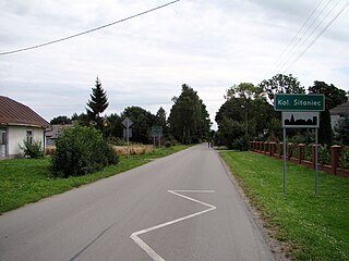
Sitaniec-Kolonia is a village in the administrative district of Gmina Zamość, within Zamość County, Lublin Voivodeship, in eastern Poland. It lies approximately 5 kilometres (3 mi) north of Zamość and 72 km (45 mi) south-east of the regional capital Lublin.
Sitaniec-Wolica is a village in the administrative district of Gmina Zamość, within Zamość County, Lublin Voivodeship, in eastern Poland. It lies approximately 6 kilometres (4 mi) north-west of Zamość and 71 km (44 mi) south-east of the regional capital Lublin.

Wysokie is a village in the administrative district of Gmina Zamość, within Zamość County, Lublin Voivodeship, in eastern Poland. It lies approximately 6 kilometres (4 mi) north-west of Zamość and 71 km (44 mi) south-east of the regional capital Lublin.


