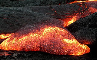
Magma is the molten or semi-molten natural material from which all igneous rocks are formed. Magma is found beneath the surface of the Earth, and evidence of magmatism has also been discovered on other terrestrial planets and some natural satellites. Besides molten rock, magma may also contain suspended crystals and gas bubbles.

Coevorden is a city and municipality in the province of Drenthe, Netherlands. During the 1998 municipal reorganisation in the province, Coevorden merged with Dalen, Sleen, Oosterhesselen and Zweeloo, retaining its name. In August 2017, it had a population of 35,267.

An oil well is a boring in the Earth that is designed to bring petroleum oil hydrocarbons to the surface. Usually some natural gas is released as associated petroleum gas along with the oil. A well that is designed to produce only gas may be termed a gas well.

Lake Nyos is a crater lake in the Northwest Region of Cameroon, located about 315 km (196 mi) northwest of Yaoundé, the capital. Nyos is a deep lake high on the flank of an inactive volcano in the Oku volcanic plain along the Cameroon line of volcanic activity. A volcanic dam impounds the lake waters.

The Yellowstone Caldera is a volcanic caldera and supervolcano in Yellowstone National Park in the Western United States, sometimes referred to as the Yellowstone Supervolcano. The caldera and most of the park are located in the northwest corner of Wyoming. The major features of the caldera measure about 34 by 45 miles.

An ice core is a core sample that is typically removed from an ice sheet or a high mountain glacier. Since the ice forms from the incremental buildup of annual layers of snow, lower layers are older than upper, and an ice core contains ice formed over a range of years. Cores are drilled with hand augers or powered drills; they can reach depths of over two miles (3.2 km), and contain ice up to 800,000 years old.

Mount Pinatubo is an active stratovolcano in the Zambales Mountains, located on the tripoint boundary of the Philippine provinces of Zambales, Tarlac and Pampanga, all in Central Luzon on the northern island of Luzon. Its eruptive history was unknown to most before the pre-eruption volcanic activities of 1991, just before June. Pinatubo was heavily eroded, inconspicuous and obscured from view. It was covered with dense forests which supported a population of several thousand indigenous Aetas.

Siljan, in Dalarna in central Sweden, is Sweden's sixth largest lake. The cumulative area of Siljan and the adjacent, smaller lakes Orsasjön and Insjön is 354 km2 (137 sq mi). Siljan reaches a maximum depth of 134 m (440 ft), and its surface is situated 161 m (528 ft) above sea level. The largest town on its shore is Mora.

Mount Unzen is an active volcanic group of several overlapping stratovolcanoes, near the city of Shimabara, Nagasaki on the island of Kyushu, Japan's southernmost main island.

Directional drilling is the practice of drilling non-vertical wells. It can be broken down into four main groups: oilfield directional drilling, utility installation directional drilling, directional boring, and surface in seam (SIS), which horizontally intersects a vertical well target to extract coal bed methane.

Lake Peigneur is a brackish lake in the U.S. state of Louisiana, 1.2 miles north of Delcambre and 9.1 mi (14.6 km) west of New Iberia, near the northernmost tip of Vermilion Bay. With a maximum depth of 200 feet, it is the deepest lake in Louisiana.

A drilling rig is an integrated system that drills wells, such as oil or water wells, in the earth's subsurface. Drilling rigs can be massive structures housing equipment used to drill water wells, oil wells, or natural gas extraction wells, or they can be small enough to be moved manually by one person and such are called augers. Drilling rigs can sample subsurface mineral deposits, test rock, soil and groundwater physical properties, and also can be used to install sub-surface fabrications, such as underground utilities, instrumentation, tunnels or wells. Drilling rigs can be mobile equipment mounted on trucks, tracks or trailers, or more permanent land or marine-based structures. The term "rig" therefore generally refers to the complex equipment that is used to penetrate the surface of the Earth's crust.

Taal Volcano is a large caldera filled by Taal Lake in the Philippines. Located in the province of Batangas, the volcano is the second-most active volcano in the Philippines, with 34 recorded historical eruptions, all of which were concentrated on Volcano Island, near the middle of Taal Lake. The caldera was formed by prehistoric eruptions between 140,000 and 5,380 BP.
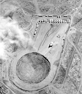
A subsidence crater is a hole or depression left on the surface of an area which has had an underground explosion. Many such craters are present at the Nevada Test Site, which is no longer in use for nuclear testing.
Scientific drilling into the Earth is a way for scientists to probe the Earth's sediments, crust, and upper mantle. In addition to rock samples, drilling technology can unearth samples of connate fluids and of the subsurface biosphere, mostly microbial life, preserved in drilled samples. Most of the technology used for drilling come from advances in the oil and gas industry. Scientific drilling is carried out on land by the International Continental Scientific Drilling Program (ICDP) and at sea by the Integrated Ocean Drilling Program (IODP). Scientific drilling on the continents includes drilling down into solid ground as well as drilling from small boats on lakes. Sampling thick glaciers and ice sheets to obtain ice cores is related but will not be described further here.

A limnic eruption, also known as a lake overturn, is a rare type of natural disaster in which dissolved carbon dioxide suddenly erupts from deep lake waters, forming a gas cloud capable of suffocating wildlife, livestock, and humans. A limnic eruption may also cause tsunamis as the rising CO
2 displaces water. Scientists believe earthquakes, volcanic activity, and other explosive events can serve as triggers for limnic eruptions. Lakes in which such activity occurs are referred to as limnically active lakes or exploding lakes. Some features of limnically active lakes include:

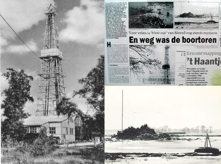
The Sidoarjo mud flow is the result of an erupting mud volcano in the subdistrict of Porong, Sidoarjo in East Java, Indonesia that has been in eruption since May 2006. It is the biggest mud volcano in the world; responsibility for it was credited to the blowout of a natural gas well drilled by PT Lapindo Brantas, although some scientists and company officials contend it was caused by a distant earthquake.

The Tseax Cone, also called the Tseax River Cone or the Aiyansh Volcano, is a young and active cinder cone and adjacent lava flows associated with the Nass Ranges and the Northern Cordilleran Volcanic Province. It is located east of Crater Creek at outlet of Melita Lake, southeast of Gitlakdamix and 60 kilometres (37 mi) north of Terrace, British Columbia, Canada.

Halemaʻumaʻu is a pit crater within the much larger Kīlauea Caldera in Hawaii Volcanoes National Park. The roughly circular crater was 770 meters (2,530 ft) x 900 m (2,950 ft) before collapses that roughly doubled the size of the crater after May 3, 2018. Following the collapses of 2018, the bottom of Halemaʻumaʻu lies roughly 600 m (2,000 ft) below the caldera floor. Halemaʻumaʻu is home to Pele, goddess of fire and volcanoes, according to the traditions of Hawaiian religion. Halemaʻumaʻu means "house of the ʻāmaʻu fern".

The Karlino oil eruption was an oil well blowout that took place on December 9, 1980, near Karlino, a town located in Pomerania in northern Poland, near the Baltic Sea coast. The eruption and the fire that followed it put an end to the hope of Poland becoming a "second Kuwait". It took more than a month for Polish, Soviet and Hungarian firefighters to completely extinguish the fire. The eruption was the result of an extensive search for underground oil deposits that took place in the area in 1980.


