
Hurricane Agnes was the costliest hurricane to hit the United States at the time, causing an estimated $2.1 billion in damage. The hurricane's death toll was 128. The effects of Agnes were widespread, from the Caribbean to Canada, with much of the east coast of the United States affected. Damage was heaviest in Pennsylvania, where Agnes was the state's wettest tropical cyclone. Due to the significant effects, the name Agnes was retired in the spring of 1973.

The Kentucky River is a tributary of the Ohio River in Kentucky, United States. The 260-mile (420 km) river and its tributaries drain much of eastern and central Kentucky, passing through the Eastern Coalfield, the Cumberland Mountains, and the Bluegrass region. Its watershed encompasses about 7,000 square miles (18,000 km2), and it supplies drinking water to about one-sixth of the population of the state.
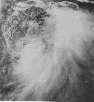
Tropical Storm Amelia was a weak but catastrophic tropical storm that was the second-wettest tropical cyclone on record in the continental United States. Amelia developed from a tropical wave that moved through the Atlantic Ocean uneventfully. The disturbance then entered an area of the Gulf of Mexico that was conducive to tropical cyclogenesis and became the first tropical depression of the season, after which it was forecast to make landfall before any significant intensification. However, the tropical depression defied predictions, quickly strengthening into a weak tropical storm just hours before making landfall in Corpus Christi. The storm lasted roughly a day over land before becoming unidentifiable after being active for just under 48 hours. After dissipating, the storm caused a severe flooding disaster in Texas.

The Los Angeles flood of 1938 was one of the largest floods in the history of Los Angeles, Orange, and Riverside Counties in southern California. The flood was caused by two Pacific storms that swept across the Los Angeles Basin in February-March 1938 and generated almost one year's worth of precipitation in just a few days. Between 113–115 people were killed by the flooding. The Los Angeles, San Gabriel, and Santa Ana Rivers burst their banks, inundating much of the coastal plain, the San Fernando and San Gabriel Valleys, and the Inland Empire. Flood control structures spared parts of Los Angeles County from destruction, while Orange and Riverside Counties experienced more damage.
Floods in the United States are generally caused by excessive rainfall, excessive snowmelt, and dam failure. Below is a list of flood events that were of significant impact to the country during the 20th century, from 1900 through 1999, inclusive.

The 2009 Great Britain and Ireland floods were a weather event that affected parts of Great Britain and Ireland throughout November and into December 2009. November was the wettest month across the United Kingdom since records began in 1914 and had well above average temperatures. The worst affected area in Great Britain was the English county of Cumbria. The Irish counties of Clare, Cork, Galway and Westmeath were among the worst affected areas of Ireland.

The Great Flood of 1862 was the largest flood in the recorded history of California, Oregon, and Nevada, inundating the western United States and portions of British Columbia and Mexico. It was preceded by weeks of continuous rains and snows that began in Oregon in November 1861 and continued into January 1862. This was followed by a record amount of rain from January 9–12, and contributed to a flood that extended from the Columbia River southward in western Oregon, and through California to San Diego, as well as extending as far inland as the Washington Territory, the Utah Territory, and the western New Mexico Territory.

The Christmas flood of 1964 was a major flood in the United States' Pacific Northwest and some of Northern California between December 18, 1964, and January 7, 1965, spanning the Christmas holiday.
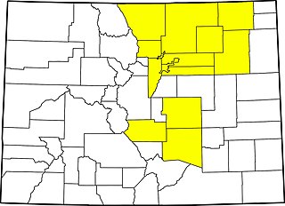
The 2013 Colorado floods were a series of natural disasters occurring in the U.S. state of Colorado. Starting on September 11, 2013, a slow-moving cold front stalled over Colorado, clashing with warm humid monsoonal air from the south. This resulted in heavy rain and catastrophic flooding along Colorado's Front Range from Colorado Springs north to Fort Collins. The situation intensified on September 11 and 12. Boulder County was worst hit, with 9.08 inches (231 mm) recorded September 12 and up to 18 inches (460 mm) of rain recorded by September 15, which is comparable to Boulder County's average annual precipitation. This event has also been referred to as the 2013 Colorado Front Range Flood, reflecting a more precise geographic extent in and along the Colorado Front Range mountains.
The 1985 Election Day floods — also known as the Killer Floods of 1985 in West Virginia — produced the costliest floods in both West Virginia and Virginia in November 1985. The event occurred after Hurricane Juan, a tropical cyclone in the 1985 Atlantic hurricane season, meandered near the coast of Louisiana before striking just west of Pensacola, Florida late on October 31. Juan moved northward into Canada, but spawned another system that spread moderate rainfall across the Mid-Atlantic States, wetting soils. On November 3, a low pressure area developed south of Florida and moved northeastward along a cold front, bringing a plume of moisture influenced by Juan's previous track. The storm moved through the southeastern United States, stalling on November 5 west of Washington, D.C. before turning out to sea the next day. The event was known as the Election Day floods due to its concurrence with elections in Virginia.

In June 2016, parts of the United Kingdom were struck by serious flash floods. Starting on 7 June, thunderstorms caused intense rainfall in many locations across the country, particularly in the north of England and in London, causing repeated flash floods in several locations on a daily basis.

The 1936 Northeastern United States flood was a historic flood that occurred across the Northeastern United States, as well as the Mid-Atlantic region and Ohio, in March 1936. Record-setting flooding after a combination of a particularly precipitation-heavy winter and large amounts of rainfall in March caused severe damage across the region.

Between November 2019 and February 2020, severe winter flooding occurred across the United Kingdom. The first wave of flooding occurred in November 2019, mainly affecting Yorkshire and the Humber, the East Midlands and the West Midlands. Further isolated flooding incidents were reported in December and January, before the second main wave of flooding, caused by Storms Ciara and Dennis, occurred in February 2020. The excessive rainfall resulted in the wettest February since records began, in 1766, in England and Wales with an average of 169.6 millimetres (6.68 in) falling across the regions, beating the record from 1833.

In July 2019, parts of the Yorkshire Dales, in North Yorkshire, England, were subjected to above average rainfall for the time of year. The flash-flooding that followed affected many communities destroying bridges, sweeping roads away, causing landslips on railway lines and resulting in at least one public event being cancelled. The flooding even inundated the fire station in the town of Leyburn, in Wensleydale, whilst the crew were out helping those in need. The recovery took many weeks and months, with immediate help by the rescue services being bolstered by British Army personnel who assisted with the clean up.

Hispaniola is an island in the Caribbean, with the second largest size throughout all of the Caribbean. Throughout the centuries, since reliable records began, hundreds of hurricanes and tropical cyclones have affected Haiti and the Dominican Republic, the two countries that share the island. The most recent tropical cyclone to affect Hispaniola was Hurricane Franklin in August 2023.
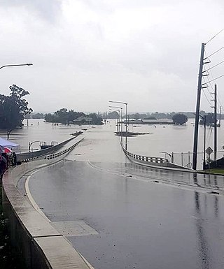
Extreme rainfall on the east coast of Australia beginning on 18 March 2021 led to widespread flooding in New South Wales, affecting regions from the North Coast to the Sydney metropolitan area in the south. Suburbs of Sydney experienced the worst flooding in 60 years, and the events were described by NSW Premier Gladys Berejiklian as "one in 100-year" flooding. Far-southeast communities in Queensland were also affected by flooding and heavy rainfall, though to a lesser extent than those in New South Wales.
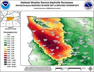
Between midnight and 10:00 am CDT on Saturday, August 21, 2021, very heavy rainfall resulted in widespread flash flooding across western Middle Tennessee, including the town of Waverly. During the event, much of a five-county area received up to a quarter of normal annual rainfall in under twelve hours, as much as 10 to 15 inches. In a situation described as catastrophic, Waverly was severely damaged by floodwater, with hundreds of homes and dozens of businesses destroyed and swept away. Numerous people became trapped, leading to widespread water rescues. The event resulted in 19 fatalities in Waverly, with another in nearby Hurricane Mills, and is regarded as one of the worst natural disasters in Tennessee history. The event broke the 24-hour rainfall record in Tennessee, with over 20 inches (510 mm) of rain falling in McEwen. Flooding also occurred in parts of western Kentucky, but to a much lesser extent.

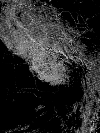
The 1911 Sonora hurricane was a deadly tropical cyclone that had effects that extended far inland, producing significant flooding in the U.S. state of Colorado. The storm originated on October 1 to the southwest of Mexico. It moved to the northwest, striking the Baja California peninsula on October 4, where it destroyed crops and buildings. After crossing the peninsula and the Gulf of California, the hurricane moved ashore the Mexican state of Sonora with strong winds and high tides. The port city of Guaymas and other nearby towns were damaged, with roofs torn and rail lines washed away. In Mexico, the storm killed between 300–500 people. The remnants of the storm moved into the southwestern United States and interacted with a shortwave trough. In Colorado, the former hurricane dropped 8.16 in (207 mm) of rain in the San Juan Mountains. This was the highest rainfall total related to an Atlantic or Pacific hurricane in the state. The rains caused flooding that killed five people in Colorado, while also washing away bridges and houses. Two lines of the Denver and Rio Grande Western Railroad were out of service for over 50 days.

North Carolina was severely impacted by Hurricane Helene during late September 2024, primarily in its western Appalachian region, causing at least 96 reported deaths and significant destruction of infrastructure and residential areas across several settlements. After making landfall in the Big Bend region of Florida on September 27, the hurricane began to traverse over land across Georgia as a Category 2 hurricane and into the Appalachian mountain range as a tropical storm, depositing record-breaking amounts of rainfall across several settlements in western North Carolina, such as Asheville, Swannanoa, Spruce Pine, Chimney Rock, Montreat, Lake Lure, and several others.

The Baltic Flood Of 1888 affected a large part of the Elbing, Marienburg and Stuhm counties. As a result, almost all of Sumpfland Weichsel and part of Danziger Werder were flooded.


