
Tainui is a tribal waka confederation of New Zealand Māori iwi. The Tainui confederation comprises four principal related Māori iwi of the central North Island of New Zealand: Hauraki, Ngāti Maniapoto, Ngāti Raukawa and Waikato. There are other Tainui iwi whose tribal areas lay outside the traditional Tainui boundaries – Ngāi Tai in the Auckland area, Ngāti Raukawa ki Te Tonga and Ngāti Toa in the Horowhenua, Kāpiti region, and Ngāti Rārua and Ngāti Koata in the northern South Island.

Waitangi Day, the national day of New Zealand, marks the anniversary of the initial signing—on 6 February 1840—of the Treaty of Waitangi. The Treaty of Waitangi was an agreement towards British sovereignty by representatives of the Crown and indigenous Māori chiefs, and so is regarded by many as the founding document of the nation.
Waitangi is a locality on the north side of the Waitangi River in the Bay of Islands, 60 kilometres north of Whangarei, on the North Island of New Zealand. It is close to the town of Paihia, to which it is connected by a bridge near the mouth of the Waitangi River estuary. While Statistics New Zealand and NZ Post consider the southern boundary of Waitangi to be the river and estuary, with the area further south being part of Paihia, the area by Te Tī Bay, immediately south of the river, is sometimes referred to as part of Waitangi.

Te Puea Hērangi, known by the name Princess Te Puea, was a Māori leader from New Zealand's Waikato region. Her mother, Tiahuia, was the elder sister of King Mahuta.

Ngāti Whātua is a Māori iwi (tribe) of the lower Northland Peninsula of New Zealand's North Island. It comprises a confederation of four hapū (subtribes) interconnected both by ancestry and by association over time: Te Uri-o-Hau, Te Roroa, Te Taoū, and Ngāti Whātua-o-Ōrākei. The four hapū can act together or separately as independent tribes.

South Auckland is one of the major geographical regions of Auckland, the largest city in New Zealand. The area is south of the Auckland isthmus, and on the eastern shores of the Manukau Harbour. The area has been populated by Tāmaki Māori since at least the 14th century, and has important archaeological sites, such as the Ōtuataua stonefield gardens at Ihumātao, and Māngere Mountain, a former pā site important to Waiohua tribes.

Onehunga is a suburb of Auckland in New Zealand and the location of the Port of Onehunga, the city's small port on the Manukau Harbour. It is eight kilometres south of the city centre, close to the volcanic cone of Maungakiekie / One Tree Hill.

Māngere is a major suburb in South Auckland, New Zealand, located on mainly flat land on the northeastern shore of the Manukau Harbour, to the northwest of Manukau City Centre and 15 kilometres south of the Auckland city centre. It is the location of Auckland Airport, which lies close to the harbour's edge to the south of the suburb.

The Māori King Movement, called the Kīngitanga in Māori, is a movement that arose among some of the Māori iwi (tribes) of New Zealand in the central North Island in the 1850s, to establish a role similar in status to that of the monarch of the British colonists, as a way of halting the alienation of Māori land. The Māori monarch operates in a non-constitutional capacity with no legal or judicial power within the New Zealand government. Reigning monarchs retain the position of paramount chief of several iwi and wield some power over these, especially within Tainui.

A wharenui is a communal house of the Māori people of New Zealand, generally situated as the focal point of a marae. Wharenui are usually called meeting houses in New Zealand English, or simply called whare . Also called a whare rūnanga or whare whakairo, the present style of wharenui originated in the early to middle nineteenth century. The houses are often carved inside and out with stylized images of the iwi's ancestors, with the style used for the carvings varying from tribe to tribe. Modern meeting houses are built to regular building standards. Photographs of recent ancestors may be used as well as carvings. The houses always have names, sometimes the name of a famous ancestor or sometimes a figure from Māori mythology. Some meeting houses are built at places that are not the location of a tribe, but where many Māori gather; typically, a school or tertiary institution with many Māori students.

Māngere Bridge is a suburb of Auckland, New Zealand, under the local governance of the Auckland Council. Surrounded by the Manukau Harbour, the area is the most north-western suburb of South Auckland, and is connected to Onehunga in central Auckland by three bridges that cross the Māngere Inlet. Many features of the Auckland volcanic field are found in and around Māngere Bridge, including Māngere Mountain, a 106-metre-high (348 ft) feature in the centre of the suburb, and Māngere Lagoon, a volcanic tidal lagoon opposite Puketutu Island in the harbour. The suburb is also home to Ambury Regional Park, a working farm and nature sanctuary run by Auckland Council, that connects to the Kiwi Esplanade and Watercare Coastal walkways.

Māngere Mountain, also known by the names Te Pane-o-Mataaho and Te Ara Pueru, is a volcanic cone in Māngere, Auckland. Located within Māngere Domain, it is one of the largest volcanic cones in the Auckland volcanic field, with a peak 106 metres (348 ft) above sea level. It was the site of a major pā and many of the pā's earthworks are still visible. It has extensive panoramic views of Auckland from its location in the southeastern portion of the city's urban area.
Ngāti Mahuta is a sub-tribe of the Waikato tribe of Māori in the North Island of New Zealand. The territory (rohe) of Ngāti Mahuta is the Kawhia and Huntly areas of the Waikato region.

State Highway 20 (SH 20), also known as the Southwestern Motorway, is a New Zealand state highway linking State Highway 1 at Manukau with State Highway 16 in Point Chevalier, via Māngere and Onehunga. Along with its spurs, State Highway 20A and 20B, the state highway serves Auckland Airport, the country's largest, therefore making SH 20 a key arterial route connecting the airport to the wider Auckland region and most of the upper North Island. The route also forms the southern part of the Western Ring Route, a 48 kilometres (30 mi) motorway route bypassing central Auckland.
Mutu Paratene Kapa was a New Zealand tribal leader, orator, sportsman, and Anglican priest. Of Māori descent, he identified with the Te Aupōuri and Waikato iwi. He was born in Ohinepu, Waikato, New Zealand, in 1870.

Tāmaki Māori are Māori iwi and hapū who have a strong connection to Tāmaki Makaurau, and whose rohe was traditionally within the region. Among Ngā Mana Whenua o Tāmaki Makaurau, also known as the Tāmaki Collective, there are thirteen iwi and hapū, organised into three rōpū (collectives), however Tāmaki Māori can also refer to subtribes and historical iwi not included in this list.

Urban Māori are Māori people living in urban areas outside the rohe of their iwi (tribe) or hapū (sub-tribe). The 2013 New Zealand census showed that 84% of Māori in New Zealand lived in urban areas, 25% lived in Auckland, and most others lived in other metropolitan centres like Wellington and Christchurch. Many Māori continued to associate with their iwi and their rohe, but more than 15% did not know their tribal affiliation.

The Māori land march of 1975 was a protest led by the group Te Rōpū Matakite, created by Dame Whina Cooper. The hīkoi (march) started in Northland on 14 September, travelled the length of the North Island, and arrived at the parliament building in Wellington on 13 October 1975. The purpose of the march was to protest the loss of Māori rights and land through the actions of Pākehā (Europeans). Over the 1,100 kilometres (680 mi) course of the march it grew from 50 to approximately 5,000 people.

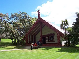
Te Puea Memorial Marae is a marae located in Māngere Bridge, Auckland, New Zealand. Opened in 1965, it was the first urban marae in Auckland, built for ngā hau e whā, but in particular as a community centre for local Urban Māori communities around Onehunga and Māngere, and for the Waikato Tainui iwi. The marae is named for Māori leader and relative of King Mahuta, Te Puea Hērangi, and is known by the whakataukī (proverb) te kei o te waka o Tainui, as it is the northernmost Waikato Tainui marae.

Nigel John Floyd Borell is a New Zealand Māori artist, museum curator, and Māori art advocate. He curated the exhibition Toi Tū Toi Ora: Contemporary Māori Art at the Auckland Art Gallery Toi o Tāmaki in 2020, the largest exhibition since they opened. In 2021 the Art Foundation of New Zealand created an award to acknowledge the work of Borrell in this exhibition.
