
Magdalena is a department of Colombia with more than 1.3 million people, located to the north of the country by the Caribbean Sea. The capital of the Magdalena Department is Santa Marta and was named after the Magdalena River. It inherited the name of one of the original nine states of the United States of Colombia that its current territory integrated.
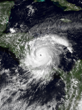
Hurricane Joan was a long lived and powerful tropical cyclone that caused death and destruction in over a dozen countries in the Caribbean and Central America. Moving on a due west course for nearly two weeks in October 1988, Hurricane Joan caused widespread flooding and over 200 deaths after moving into Central America. Widespread suffering and economic crises were exacerbated by Joan, primarily across Nicaragua, as heavy rains and high winds impacted those near the hurricane's path.
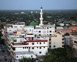
Maicao is a city and municipality in the Department of La Guajira, northern Republic of Colombia. It is located 76 km from Riohacha, the capital of the department and is the second largest urban center near the border with Venezuela, after the city of Cúcuta.

Tropical Storm Bret was the deadliest natural disaster in Venezuela since the 1967 Caracas earthquake. The third tropical cyclone of the 1993 Atlantic hurricane season, Bret formed on August 4 from a westward-moving, African tropical wave. Bret would later peak as a 60 mph (97 km/h) tropical storm as it neared Trinidad. It took an extremely southerly course through the Caribbean, passing over the coasts of Venezuela and Colombia. High terrain in the northern parts of those countries severely disrupted the circulation of the storm, and Bret had weakened to a tropical depression before emerging over the extreme southwestern Caribbean Sea. There, it restrengthened to a tropical storm and made landfall in Nicaragua on August 10, dissipating soon after. Bret's remnants reached the Pacific Ocean, where they would later regenerate into Hurricane Greg.
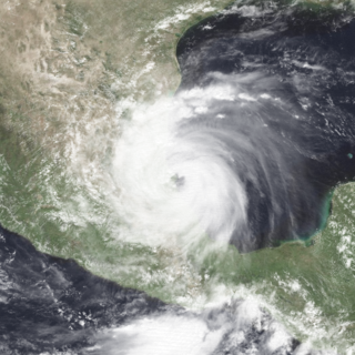
Hurricane Gert was a large tropical cyclone that caused extensive flooding and mudslides throughout Central America and Mexico in September 1993. The seventh named storm and third hurricane of the annual hurricane season, Gert originated as a tropical depression from a tropical wave over the southwestern Caribbean Sea on September 14. The next day, the cyclone briefly attained tropical storm strength before moving ashore in Nicaragua and proceeding through Honduras. It reorganized into a tropical storm over the Gulf of Honduras on September 17, but weakened back to a depression upon crossing the Yucatán Peninsula. Once over the warm waters of the Bay of Campeche, Gert quickly strengthened into a Category 2 hurricane by September 20. The hurricane made a final landfall on the Gulf Coast of Mexico near Tuxpan, Veracruz, with peak winds of 100 mph (160 km/h). The rugged terrain disrupted the cyclone's structure; Gert entered the Pacific Ocean as a depression near the state of Nayarit on September 21, where it briefly redeveloped a few strong thunderstorms before dissipating at sea five days later.

Hurricane Lili was a relatively long-lived hurricane of the 1996 Atlantic hurricane season that affected countries from Central America to the United Kingdom. Lili formed on October 14 from a tropical wave, which emerged from the coast of west Africa on October 4. After the storm formed, further strengthening of Lili was gradual, first to tropical storm status on October 16 and then to hurricane status on October 17. The next day, Lili struck Cuba and moved across the central portion of the island, the first hurricane to hit the country since Hurricane Kate in 1985. After emerging into the Atlantic Ocean, the hurricane accelerated northeastward, briefly peaking as a category 3 hurricane on the Saffir-Simpson Hurricane Scale near the Bahamas. For almost an entire week, Hurricane Lili oscillated in intensity while fluctuating several times in forward speed. About two weeks passed before Lili transitioned into an extratropical storm north of the Azores on October 27, which subsequently moved across Ireland and Great Britain.

The Vargas tragedy was a natural disaster that occurred in Vargas State, Venezuela on 15 December 1999, when torrential rains caused flash floods and debris flows that killed tens of thousands of people, destroyed thousands of homes, and led to the complete collapse of the state's infrastructure. According to relief workers, the neighborhood of Los Corales was buried under 3 metres (9.8 ft) of mud and a high percentage of homes were simply swept into the ocean. Entire towns including Cerro Grande and Carmen de Uria completely disappeared. As much as 10% of the population of Vargas died during the event.

La Guajira is a department of Colombia. It occupies most of the Guajira Peninsula in the northeast region of the country, on the Caribbean Sea and bordering Venezuela, at the northernmost tip of South America. The capital city of the department is Riohacha.

Manaure or Salinas de Manaure is a town and municipality located in the Colombian Department of La Guajira. Manaure's main economic activity is the exploitation of the vast amounts of salt in the area.

Barrancas is a town and municipality of the Colombian Department of La Guajira. The municipality of Barrancas is located to the left margin of the Ranchería River in a valley formed between the Sierra Nevada de Santa Marta mountains and the Serranía del Perijá. Barrancas has a total area of 742 km2 and at 40 meters over sea level. The average temperature is 28 °C throughout the year and distances from the capital of the Department of La Guajira, Riohacha. It became a municipality in 1892.

Uribia is a town and municipality of the La Guajira department of Colombia. It is the youngest municipality of this Department since the year 2000. Northern Zone of the Cerrejón coal mines are located in this municipality. The municipality also contains the Serranía de Macuira mountain range which is an isolated low altitude mountain range in the middle of La Guajira Desert. One third of this mountain range is also a National Natural Park of Colombia.

In October 1999, severe flooding affected portions of eastern Mexico and Central America. Rainfall in September preceded the primary event in Mexico, which moistened soils. On October 4, Tropical Depression Eleven developed in the Gulf of Mexico, which drew humidity from the gulf and the Pacific Ocean to produce torrential rainfall in mountainous regions of eastern Mexico, reaching 43.23 in (1,098 mm) in Jalacingo, Veracruz. This was the third-highest tropical cyclone-related rainfall total in Mexico from 1980–2006, and the event caused the highest rainfall related to tropical cyclones in Veracruz, Hidalgo, and Puebla. In some locations, the daily rainfall represented over 10% of the annual precipitation total. The heaviest rainfall occurred in mountainous regions that were the mouths of several rivers. A broad trough absorbed the depression on October 6, and rainfall continued for the next few days. Additional rainfall occurred in Tabasco state on October 18. The floods were estimated as a 1 in 67 year event in one location, although such floods are expected to affect eastern Mexico twice per century, the last time being 1944.

Hurricane Beta was a compact and intense tropical cyclone that impacted the southwestern Caribbean in late October 2005. Beta was the twenty-fourth tropical storm, fourteenth hurricane, and seventh and final major hurricane of the record-breaking 2005 Atlantic hurricane season. On October 21, a developing tropical wave entered the eastern Caribbean Sea and spawned Tropical Storm Alpha the following day. As the wave entered the southwestern Caribbean, convection redeveloped and on October 26, the system spawned another low-pressure area which developed into Tropical Depression Twenty-six. The depression intensified into a tropical storm the next morning and was named Beta. By the morning of October 28, the storm intensified into a hurricane, the fourteenth of the season. Beta underwent rapid intensification for several hours to attain its peak intensity with winds of 115 mph (185 km/h) on October 30. The storm began to deteriorate before landfall, weakening to Category 2 status as it crossed the Nicaraguan coastline. Rapid weakening followed landfall, and the storm dissipated early the next morning.

Tropical Storm Agatha was a weak but deadly tropical cyclone that brought widespread floods to much of Central America, and was the deadliest storm in the eastern Pacific tropical cyclone basin since Hurricane Pauline in 1997. The first named storm of the 2010 Pacific hurricane season, Agatha originated from the Intertropical Convergence Zone, a region of thunderstorms across the tropics. It developed into a tropical depression on May 29 and tropical storm later, it was dissipated on May 30, reaching top winds of 45 mph and a lowest pressure of 1000 mbar. It made landfall near the Guatemala–Mexico border on the evening of May 29. Agatha produced torrential rain all across Central America, which resulted in the death of one person in Nicaragua. In Guatemala, 152 people were killed and 100 left missing by landslides. Thirteen deaths also occurred in El Salvador. Agatha soon dissipated over Guatemala. As of June 15, officials in Guatemala have stated that 165 people were killed and 113 others are missing.
A series of floods in Colombia began in late April 2011, coinciding with the country's rainy season. Torrential rains triggered extensive flooding and landslides that killed at least 187 people and 1.2 million people affected by the devastating flood. It destroyed and damaged 1450 and 149270 houses respectively and left more than 69,000 homeless. Estimates have placed damage at US$5 billion. After September, a second wave of flooding and landslides killed another 81 people, wounded 65 more and affected approximately 289,000. However the heavy rain and flooding effected 28 out of 32 departments of Colombia.

From December 2016 and continuing until May 2017, much of western and central South America was plagued by persistent heavy rain events. In Peru, one of the most severely impacted nations, it has been referred to as the 2017 Coastal Niño. The flooding was preceded by drought-like conditions throughout the region for much of 2016 and a strong warming of sea temperatures off the coast of Peru.
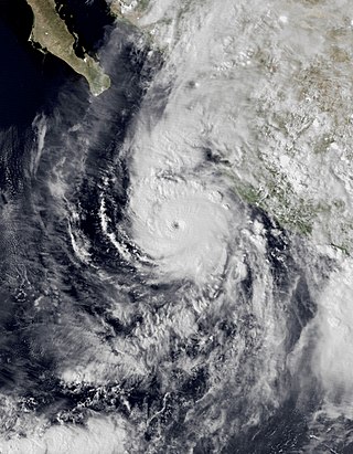
Hurricane Willa was a powerful tropical cyclone that brought torrential rains and destructive winds to southwestern Mexico, particularly the states of Sinaloa and Nayarit, during late October 2018. It was the twenty-fifth tropical cyclone, twenty-second named storm, thirteenth hurricane, tenth major hurricane, and record-tying third Category 5 hurricane of the 2018 Pacific hurricane season. Willa was the first major hurricane to make landfall in the Mexican state of Sinaloa since Lane in 2006.

Hurricane Iota was a devastating late-season Category 4 Atlantic hurricane which caused severe damage to areas of Central America already devastated by Hurricane Eta just less than two weeks prior. The 31st and final tropical cyclone, 30th named storm, 14th hurricane, and record-tying seventh major hurricane of the record-breaking 2020 Atlantic hurricane season, Iota originated as a tropical wave that moved into the Eastern Caribbean on November 10. Over the next few days, the wave began to become better organized and by November 13, it developed into a tropical depression north of Colombia. The depression strengthened into Tropical Storm Iota six hours later. The storm was initially impacted by some wind shear, but a center relocation and relaxed shear allowed Iota to quickly strengthen into a hurricane on November 15, after which it underwent explosive intensification, peaking as a high-end Category 4 storm, with wind speeds of 155 mph (249 km/h). After weakening slightly, Iota made landfall in northeastern Nicaragua as a mid-range Category 4 hurricane, becoming the strongest recorded hurricane to make landfall in Nicaragua in November. Iota then rapidly weakened as it moved inland, dissipating on November 18.

Hurricane Julia was a deadly tropical cyclone that caused significant impacts in Central America as a Category 1 hurricane in October 2022. The tenth named storm and fifth hurricane of the 2022 Atlantic hurricane season, Julia formed from a tropical wave over the southern Caribbean Sea on October 7, just off the coast of South America. Only one storm on record, Tropical Storm Bret in 1993, has tracked further south over South America.

