| |||||
| Decades: | |||||
|---|---|---|---|---|---|
| See also: | Other events of 2010 Timeline of Cabo Verdean history | ||||

The following events happened in Cape Verde in the year 2010.
| |||||
| Decades: | |||||
|---|---|---|---|---|---|
| See also: | Other events of 2010 Timeline of Cabo Verdean history | ||||
The following events happened in Cape Verde in the year 2010.

Mindelo is a port city in the northern part of the island of São Vicente in Cape Verde. Mindelo is also the seat of the parish of Nossa Senhora da Luz, and the municipality of São Vicente. The city is home to 93% of the entire island's population. Mindelo is known for its colourful and animated carnival celebrations, with roots in Portuguese traditions later influenced by the Brazilian culture.

The Cape Verde national football team represents Cape Verde in men's international football, and is controlled by the Cape Verdean Football Federation. The team has never qualified for the FIFA World Cup, but has qualified for four Africa Cup of Nations tournaments, in 2013, 2015, 2021 and 2023. The team achieved their best result in 2023 after making it past the first round of the knockout stage.

Assomada is a city on the Sotavento (leeward) island of Santiago in Cape Verde. Since 1912, it is the seat of the municipality of Santa Catarina, which comprises the central western part and much of the interior of the island. It is the largest city in that region.

Santa Maria is a city in the southern part of the island municipality of Sal, Cape Verde. It is located on the south coast, about 16 km south of the Amílcar Cabral International Airport, and 20 km south of the island capital Espargos.

Achada Furna is a settlement in the southern part of the island of Fogo, Cape Verde. It is situated 15 km east of the island capital São Filipe. At the 2010 census its population was 495. Its elevation is about 870 meters. Nearby places include Cabeça Fundão to the north, Figueira Pavão to the east, Fonte Aleixo to the south and Monte Largo to the west.

The territory of Cape Verde is divided into 22 concelhos (municipalities), and subdivided into 32 freguesias.

Coculi is a town in the northern part of the island of Santo Antão, Cape Verde. It is situated on the river Ribeira Grande, 4 km southwest of the town Ribeira Grande and 17 km north of the island capital Porto Novo. About 400 meters to its west is the confluence of Ribeira de Chã das Pedras.

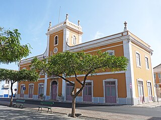
Pombas is a city in the northeastern part of the island of Santo Antão, Cape Verde. It is the seat of the municipality Paul. It is situated on the coast, at the mouth of the Ribeira do Paul, 7 km (4.3 mi) southeast of Ribeira Grande and 15 km (9.3 mi) north of the island capital Porto Novo. The national roads EN1-SA02 and EN1-SA03 connect Pombas with Ribeira Grande and Porto Novo, respectively. Pombas was elevated from town to city in 2010.
Lombo Branco is a settlement in the northeastern part of the island of Santo Antão, Cape Verde. It is situated 4 km southeast of Ribeira Grande and 17 km north of the island capital Porto Novo.
Juncalinho is a town in the eastern part of the island of São Nicolau, Cape Verde. It is situated on the north coast, 17 km east of Ribeira Brava. The local football club is FC Belo Horizonte.
Barreiro is a town in the southern part of the island of Maio, Cape Verde. It is around 5 km east of the island capital Porto Inglês. At the 2010 census, its population was 535.

São Jorge is a settlement in the central part of the island of Santiago, Cape Verde. It is part of the São Lourenço dos Órgãos municipality. In 2010 its population was 6. It is situated 2.5 km southwest of João Teves and 4 km southeast of Picos. Its elevation is 319 meters.
Praia is a concelho (municipality) of Cape Verde. It is situated in the southern part of the island of Santiago. Its seat is the city Praia, the capital of Cape Verde. Its area is 120.6 km2 (46.6 sq mi), and its population was 131,719 at the 2010 census. The municipality consists of one freguesia, Nossa Senhora da Graça. The city hall is located in the Platô part of the city.

Ribeira Grande is the largest town of the Ribeira Grande Municipality on the island of Santo Antão, Cape Verde. It has become a city in 2010. In 2010 its population was 2,564. It is situated in the northeastern part of the island, near the outflow of the river Ribeira Grande and its tributary Ribeira da Torre into the Atlantic Ocean. Neighborhoods include Tarrafal, Rua de Agua, Rua d'Horta and Penha de França.

Cape Verde or Cabo Verde, officially the Republic of Cabo Verde, is an archipelago and island country of West Africa in the central Atlantic Ocean, consisting of ten volcanic islands with a combined land area of about 4,033 square kilometres (1,557 sq mi). These islands lie between 600 and 850 kilometres west of Cap-Vert, the westernmost point of continental Africa. The Cape Verde islands form part of the Macaronesia ecoregion, along with the Azores, the Canary Islands, Madeira and the Savage Isles.
Montanha is a settlement in the central part of the island of Santiago, Cape Verde. It is situated 2 km north of João Teves and 8 km southwest of Pedra Badejo. The area is intensively farmed; mainly maize, beans and sugar-cane.
Cape Verdeans, also called Cabo Verdeans, are a people native to Cape Verde, an island nation in West Africa consisting of an archipelago in the central Atlantic Ocean. Cape Verde is a multi-ethnic society, which means that it is home to people of many different ethnic backgrounds. Cabo Verdeans do not consider their nationality as an ethnicity but as a citizenship with various ethnicities.
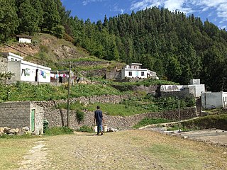
Pico da Cruz is a settlement in the northeastern part of the island of Santo Antão, Cape Verde. In 2010 its population was 138. It is situated 6 km southwest of Pombas and 10 km northeast of the island capital Porto Novo. Its elevation is about 1,400 meters. The village is named after the nearby mountain Pico da Cruz. It lies in the Cova-Paul-Ribeira da Torre Natural Park.
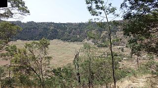
Cova is a volcanic caldera in the east-central part of the island of Santo Antão in Cape Verde. It is situated at the southwestern end of the municipality of Paul. Its lowest point is 1,166 meters, and the highest point of the crater rim is about 1,500 m. The diameter of the caldera is about 1.0 km. It forms a part of Cova-Paul-Ribeira da Torre Natural Park. The Cova formation dates from between 1.4 million and 700,000 years ago.