| |||||
| Decades: | |||||
|---|---|---|---|---|---|
| See also: | |||||

This is a list of events occurring in Antarctica in 2014.
| |||||
| Decades: | |||||
|---|---|---|---|---|---|
| See also: | |||||
This is a list of events occurring in Antarctica in 2014.

The Pleistocene is the geological epoch that lasted from c. 2.58 million to 11,700 years ago, spanning the Earth's most recent period of repeated glaciations. Before a change was finally confirmed in 2009 by the International Union of Geological Sciences, the cutoff of the Pleistocene and the preceding Pliocene was regarded as being 1.806 million years Before Present (BP). Publications from earlier years may use either definition of the period. The end of the Pleistocene corresponds with the end of the last glacial period and also with the end of the Paleolithic age used in archaeology. The name is a combination of Ancient Greek πλεῖστος (pleîstos), meaning "most", and καινός, meaning "new".
A drumlin, from the Irish word droimnín, first recorded in 1833, in the classical sense is an elongated hill in the shape of an inverted spoon or half-buried egg formed by glacial ice acting on underlying unconsolidated till or ground moraine. Assemblages of drumlins are referred to as fields or swarms; they can create a landscape which is often described as having a 'basket of eggs topography'.

The Last Glacial Period (LGP), also known colloquially as the Last Ice Age or simply Ice Age, occurred from the end of the Last Interglacial to the end of the Younger Dryas, encompassing the period c. 115,000 – c. 11,700 years ago.
A glacial period is an interval of time within an ice age that is marked by colder temperatures and glacier advances. Interglacials, on the other hand, are periods of warmer climate between glacial periods. The Last Glacial Period ended about 15,000 years ago. The Holocene is the current interglacial. A time with no glaciers on Earth is considered a greenhouse climate state.
The Vestfold Hills are rounded, rocky, coastal hills, 512 square kilometres (198 sq mi) in extent, on the north side of Sorsdal Glacier on the Ingrid Christensen Coast of Princess Elizabeth Land, Antarctica. The hills are subdivided by three west-trending peninsulas bounded by narrow fjords. Most of the hills range between 30 and 90 metres in height, with the highest summit reaching nearly 160 metres (520 ft).

The Framnes Mountains is a group of Antarctic mountain ranges in Mac. Robertson Land, to the south of the Mawson Coast. The range is surrounded by, and largely covered by, an ice sheet.
The David Range (67°54′S62°30′E is a mountain range that extends for 26 kilometres in the Framnes Mountains of Mac.Robertson Land in Antarctica. The range is surrounded by, and largely covered by, an ice sheet. Only the peaks are visible.

The Quaternary glaciation, also known as the Pleistocene glaciation, is an alternating series of glacial and interglacial periods during the Quaternary period that began 2.58 Ma and is ongoing. Although geologists describe this entire period up to the present as an "ice age", in popular culture this term usually refers to the most recent glacial period, or to the Pleistocene epoch in general. Since Earth still has polar ice sheets, geologists consider the Quaternary glaciation to be ongoing, though currently in an interglacial period.
Hodgson Lake is a perennially ice-covered freshwater lake, which is about 2 km (1.2 mi) long by about 1.5 km (0.93 mi) wide. It is located within the southern part of Alexander Island, west of Palmer Land in Antarctica, at approximately 72°S latitude and 68°W longitude. This lake has a 93.4 m (306 ft) deep water column that lies sealed beneath a 3.6 to 4.0 m thick perennial lake ice. The lake is an ultra-oligotrophic lake with very low nutrient content and very low productivity. There is no detectable life living in Hodgson Lake. The lake extends eastward into George VI Sound and the George VI Ice Shelf making it adjacent to the sound. The northern side of this lake is bounded by the Saturn Glacier, which flows east into George VI Sound. The lake lies next to and southeast of Citadel Bastion, a pre-eminent mountain on Alexander Island.

A tunnel valley is a U-shaped valley originally cut under the glacial ice near the margin of continental ice sheets such as that now covering Antarctica and formerly covering portions of all continents during past glacial ages. They can be as long as 100 km (62 mi), 4 km (2.5 mi) wide, and 400 m (1,300 ft) deep.

The retreat of glaciers since 1850 is well documented and is one of the effects of climate change. The retreat of mountain glaciers, notably in western North America, Asia, the Alps and tropical and subtropical regions of South America, Africa and Indonesia, provide evidence for the rise in global temperatures since the late 19th century. The acceleration of the rate of retreat since 1995 of key outlet glaciers of the Greenland and West Antarctic ice sheets may foreshadow a rise in sea level, which would affect coastal regions. Excluding peripheral glaciers of ice sheets, the total cumulated global glacial losses over the 26-year period from 1993 to 2018 were likely 5500 gigatons, or 210 gigatons per yr.

The East Antarctic Ice Sheet (EAIS) lies between 45° west and 168° east longitudinally. It was first formed around 34 million years ago, and it is the largest ice sheet on the entire planet, with far greater volume than the Greenland ice sheet or the West Antarctic Ice Sheet (WAIS), from which it is separated by the Transantarctic Mountains. The ice sheet is around 2.2 km (1.4 mi) thick on average and is 4,897 m (16,066 ft) at its thickest point. It is also home to the geographic South Pole, South Magnetic Pole and the Amundsen–Scott South Pole Station.

Reclus, also written as Reclús, is a volcano located in the Southern Patagonian Ice Field, Chile. Part of the Austral Volcanic Zone of the Andes, its summit rises 1,000 metres (3,300 ft) above sea level and is capped by a crater about 1 kilometre (0.62 mi) wide. Close to the volcano lies the Amalia Glacier, which is actively eroding Reclus.

The Brown Range or Sørtindane Peaks is a group of seven peaks in the Framnes Mountains about four kilometres (2.5 mi) south of Mount Twintop in Mac. Robertson Land, Antarctica.
Citadel Bastion is a rocky, flat-topped elevation at the south side of the terminus of Saturn Glacier, facing towards George VI Sound and the Rymill Coast, situated on the east side of Alexander Island, Antarctica. Its maximum elevation is about 645 m. Citadel Bastion lies next to Hodgson Lake. This mountain was mapped from trimetrogon air photography taken by the Ronne Antarctic Research Expedition, 1947–48, and from survey by the Falkland Islands Dependencies Survey, 1948–50. The name applied by the UK Antarctic Place-Names Committee because it resembles a fortified structure with a watchtower at the end of a wall.

Meltwater pulse 1B (MWP1b) is the name used by Quaternary geologists, paleoclimatologists, and oceanographers for a period of either rapid or just accelerated post-glacial sea level rise that some hypothesize to have occurred between 11,500 and 11,200 calendar years ago at the beginning of the Holocene and after the end of the Younger Dryas. Meltwater pulse 1B is also known as catastrophic rise event 2 (CRE2) in the Caribbean Sea.
Joanne S. Johnson is a geologist and Antarctic scientist, who has worked for British Antarctic Survey (BAS) since 2002. She works in the palaeoenvironments, ice sheets and climate change team and is best known for her work on glacial retreat. She was awarded the Polar medal in 2023. The Johnson Mesa in James Ross Island, Antarctica is named in her honour.
Fueguino is a volcanic field in Chile. The southernmost volcano in the Andes, it lies on Tierra del Fuego's Cook Island and also extends over nearby Londonderry Island. The field is formed by lava domes, pyroclastic cones, and a crater lake.
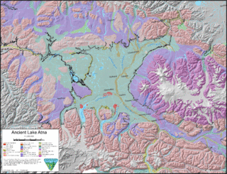
Lake Atna was a prehistoric proglacial lake that initially formed approximately 58 ka in the Copper River Basin, an area roughly centered around 245 km (152 mi) northeast of modern-day Anchorage, Alaska. The lake formed, and dispersed, during the Wisconsin glaciation. The lake existed in several forms, with several prominent shorelines observable in modern geology. At its greatest extent, the lake surface area was approximately half the size of modern-day Lake Ontario, and possibly much larger. The basin of the lake lay within an area bordered by the Alaska Range to the north, the Wrangell Mountains to the east, the Chugach Mountains to the south, and the Talkeetna Mountains to the west.
The Late Cenozoic Ice Age, or Antarctic Glaciation, began 34 million years ago at the Eocene-Oligocene Boundary and is ongoing. It is Earth's current ice age or icehouse period. Its beginning is marked by the formation of the Antarctic ice sheets.