| |||||
| Decades: | |||||
|---|---|---|---|---|---|
| See also: | |||||

This is a list of events occurring in Antarctica in 2017.
| |||||
| Decades: | |||||
|---|---|---|---|---|---|
| See also: | |||||
This is a list of events occurring in Antarctica in 2017.
Lake Vostok is the largest of Antarctica's 675 known subglacial lakes. Lake Vostok is located at the southern Pole of Cold, beneath Russia's Vostok Station under the surface of the central East Antarctic Ice Sheet, which is at 3,488 m (11,444 ft) above mean sea level. The surface of this fresh water lake is approximately 4,000 m (13,100 ft) under the surface of the ice, which places it at approximately 500 m (1,600 ft) below sea level.

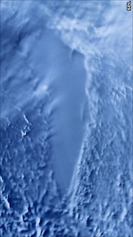
The Ross Sea is a deep bay of the Southern Ocean in Antarctica, between Victoria Land and Marie Byrd Land and within the Ross Embayment, and is the southernmost sea on Earth. It derives its name from the British explorer James Clark Ross who visited this area in 1841. To the west of the sea lies Ross Island and Victoria Land, to the east Roosevelt Island and Edward VII Peninsula in Marie Byrd Land, while the southernmost part is covered by the Ross Ice Shelf, and is about 200 miles (320 km) from the South Pole. Its boundaries and area have been defined by the New Zealand National Institute of Water and Atmospheric Research as having an area of 637,000 square kilometres (246,000 sq mi).

The Ross Ice Shelf is the largest ice shelf of Antarctica. It is several hundred metres thick. The nearly vertical ice front to the open sea is more than 600 kilometres (370 mi) long, and between 15 and 50 metres high above the water surface. Ninety percent of the floating ice, however, is below the water surface.

An ice core is a core sample that is typically removed from an ice sheet or a high mountain glacier. Since the ice forms from the incremental buildup of annual layers of snow, lower layers are older than upper ones, and an ice core contains ice formed over a range of years. Cores are drilled with hand augers or powered drills; they can reach depths of over two miles (3.2 km), and contain ice up to 800,000 years old.

Victoria Land is a region in eastern Antarctica which fronts the western side of the Ross Sea and the Ross Ice Shelf, extending southward from about 70°30'S to 78°00'S, and westward from the Ross Sea to the edge of the Antarctic Plateau. It was discovered by Captain James Clark Ross in January 1841 and named after Queen Victoria. The rocky promontory of Minna Bluff is often regarded as the southernmost point of Victoria Land, and separates the Scott Coast to the north from the Hillary Coast of the Ross Dependency to the south.

Lake Vida is a hypersaline lake in Victoria Valley, the northernmost of the large McMurdo Dry Valleys, on the continent of Antarctica. It is isolated under year-round ice cover, and is considerably more saline than seawater. It came to public attention in 2002 when microbes frozen in its ice cover for more than 2,800 years were successfully thawed and reanimated.
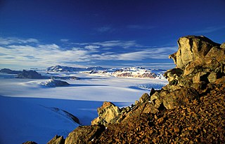
The Transantarctic Mountains comprise a mountain range of uplifted rock in Antarctica which extends, with some interruptions, across the continent from Cape Adare in northern Victoria Land to Coats Land. These mountains divide East Antarctica and West Antarctica. They include a number of separately named mountain groups, which are often again subdivided into smaller ranges.

The McMurdo Sound is a sound in Antarctica, known as the southernmost passable body of water in the world, located approximately 1,300 kilometres (810 mi) from the South Pole.

The Pensacola Mountains are a large group of mountain ranges and peaks that extend 280 nautical miles in a northeast–southwest direction in the Transantarctic Mountains System, Queen Elizabeth Land region of Antarctica. They comprise the Argentina Range, Forrestal Range, Dufek Massif, Cordiner Peaks, Neptune Range, Patuxent Range, Rambo Nunataks and Pecora Escarpment. These mountain units lie astride the extensive Foundation Ice Stream and Support Force Glacier which drain northward to the Ronne Ice Shelf.

The Drygalski Ice Tongue, Drygalski Barrier, or Drygalski Glacier Tongue is a glacier in Antarctica, on the Scott Coast, in the northern McMurdo Sound of Ross Dependency, 240 kilometres (150 mi) north of Ross Island. The Drygalski Ice Tongue is stable by the standards of Antarctica's icefloes, and stretches 70 kilometres (43 mi) out to sea from the David Glacier, reaching the sea from a valley in the Prince Albert Mountains of Victoria Land. The Drygalski Ice Tongue ranges from 14 to 24 kilometres wide.

West Antarctica, or Lesser Antarctica, one of the two major regions of Antarctica, is the part of that continent that lies within the Western Hemisphere, and includes the Antarctic Peninsula. It is separated from East Antarctica by the Transantarctic Mountains and is covered by the West Antarctic Ice Sheet. It lies between the Ross Sea, and the Weddell Sea. It may be considered a giant peninsula, stretching from the South Pole towards the tip of South America.
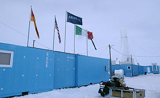
ANDRILL is a scientific drilling project in Antarctica gathering information about past periods of global warming and cooling.

Antarctica is Earth's southernmost and least-populated continent. Situated almost entirely south of the Antarctic Circle and surrounded by the Southern Ocean, it contains the geographic South Pole. Antarctica is the fifth-largest continent, being about 40% larger than Europe, and has an area of 14,200,000 km2 (5,500,000 sq mi). Most of Antarctica is covered by the Antarctic ice sheet, with an average thickness of 1.9 km (1.2 mi).

Blood Falls is an outflow of an iron(III) oxide–tainted plume of saltwater, flowing from the tongue of Taylor Glacier onto the ice-covered surface of West Lake Bonney in the Taylor Valley of the McMurdo Dry Valleys in Victoria Land, East Antarctica.
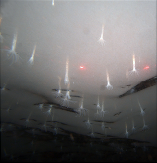
Edwardsiella andrillae is a species of sea anemone that uniquely lives anchored to the underside of sea ice offshore of Antarctica. It was discovered in December 2010 during a test run of an undersea robot by a team of researchers associated with the Antarctic Geological Drilling (ANDRILL) Program. The newly discovered anemone was named for the aforementioned program.

The Ross expedition was a voyage of scientific exploration of the Antarctic in 1839 to 1843, led by James Clark Ross, with two unusually strong warships, HMS Erebus and HMS Terror. It explored what is now called the Ross Sea and discovered the Ross Ice Shelf. On the expedition, Ross discovered the Transantarctic Mountains and the volcanoes Mount Erebus and Mount Terror, named after each ship. The young botanist Joseph Dalton Hooker made his name on the expedition.
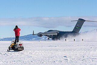
Phoenix Airfield is an airstrip in Antarctica opened in early 2017, designed to replace the Pegasus Field's role in serving McMurdo Station.
The following is a list of events that occurred in Antarctica in 2016.
Jane Kathryn Willenbring is an American geomorphologist and professor at Stanford University. She is best known for using cosmogenic nuclides to investigate landscape changes and dynamics. She has won multiple awards including the Antarctica Service Medal and the National Science Foundation CAREER Award.
The McMurdo Volcanic Group is a large group of Cenozoic volcanic rocks in the western Ross Sea and central Transantarctic Mountains areas of Antarctica. It is one of the largest provinces of alkaline volcanism in the world, having formed as a result of continental rifting along the West Antarctic Rift System. The McMurdo Volcanic Group is part of the Western Ross Supergroup, a stratigraphic unit that also includes the Meander Intrusive Group.
| 19th century | |
|---|---|
| 20th century |
|
| 21st century | |