| |||||
| Decades: | |||||
|---|---|---|---|---|---|
| See also: | |||||

Events from the year 2019 in Antarctica .
| |||||
| Decades: | |||||
|---|---|---|---|---|---|
| See also: | |||||
Events from the year 2019 in Antarctica .
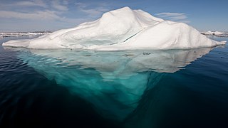
An iceberg is a piece of freshwater ice more than 15 m long that has broken off a glacier or an ice shelf and is floating freely in open (salt) water. Smaller chunks of floating glacially derived ice are called "growlers" or "bergy bits". Much of an iceberg is below the water's surface, which led to the expression "tip of the iceberg" to illustrate a small part of a larger unseen issue. Icebergs are considered a serious maritime hazard.

The Ross Ice Shelf is the largest ice shelf of Antarctica. It is several hundred metres thick. The nearly vertical ice front to the open sea is more than 600 kilometres (370 mi) long, and between 15 and 50 metres high above the water surface. Ninety percent of the floating ice, however, is below the water surface.

An ice shelf is a large platform of glacial ice floating on the ocean, fed by one or multiple tributary glaciers. Ice shelves form along coastlines where the ice thickness is insufficient to displace the more dense surrounding ocean water. The boundary between the ice shelf (floating) and grounded ice is referred to as the grounding line; the boundary between the ice shelf and the open ocean is the ice front or calving front.

The Filchner–Ronne Ice Shelf or Ronne–Filchner Ice Shelf is an Antarctic ice shelf bordering the Weddell Sea.

The Amundsen Sea is an arm of the Southern Ocean off Marie Byrd Land in western Antarctica. It lies between Cape Flying Fish to the east and Cape Dart on Siple Island to the west. Cape Flying Fish marks the boundary between the Amundsen Sea and the Bellingshausen Sea. West of Cape Dart there is no named marginal sea of the Southern Ocean between the Amundsen and Ross Seas. The Norwegian expedition of 1928–1929 under Captain Nils Larsen named the body of water for the Norwegian polar explorer Roald Amundsen while exploring this area in February 1929.

Alexander Island, which is also known as Alexander I Island, Alexander I Land, Alexander Land, Alexander I Archipelago, and Zemlja Alexandra I, is the largest island of Antarctica. It lies in the Bellingshausen Sea west of Palmer Land, Antarctic Peninsula from which it is separated by Marguerite Bay and George VI Sound. The George VI Ice Shelf entirely fills George VI Sound and connects Alexander Island to Palmer Land. The island partly surrounds Wilkins Sound, which lies to its west. Alexander Island is about 390 kilometres (240 mi) long in a north–south direction, 80 kilometres (50 mi) wide in the north, and 240 kilometres (150 mi) wide in the south. Alexander Island is the second-largest uninhabited island in the world, after Devon Island.

The Larsen Ice Shelf is a long ice shelf in the northwest part of the Weddell Sea, extending along the east coast of the Antarctic Peninsula from Cape Longing to Smith Peninsula. It is named after Captain Carl Anton Larsen, the master of the Norwegian whaling vessel Jason, who sailed along the ice front as far as 68°10' South during December 1893. In finer detail, the Larsen Ice Shelf is a series of shelves that occupy distinct embayments along the coast. From north to south, the segments are called Larsen A, Larsen B, and Larsen C by researchers who work in the area. Further south, Larsen D and the much smaller Larsen E, F and G are also named.

The McMurdo Sound is a sound in Antarctica, known as the southernmost passable body of water in the world, located approximately 1,300 kilometres (810 mi) from the South Pole.

The Bay of Whales was a natural ice harbour, or iceport, indenting the front of the Ross Ice Shelf just north of Roosevelt Island, Antarctica. It holds the distinction of being the southernmost point of open ocean, not only within the Ross Sea but worldwide. While the Ross Sea stretches considerably further south – encompassing the Gould Coast, located around 320 kilometres from the South Pole – the majority of this expanse is covered by the Ross Ice Shelf, rather than open sea.

Iceberg B-15 was the largest recorded iceberg by area. It measured around 295 by 37 kilometres, with a surface area of 11,000 square kilometres, about the size of the island of Jamaica. Calved from the Ross Ice Shelf of Antarctica in March 2000, Iceberg B-15 broke up into smaller icebergs, the largest of which was named Iceberg B-15-A. In 2003, B-15A drifted away from Ross Island into the Ross Sea and headed north, eventually breaking up into several smaller icebergs in October 2005. In 2018, a large piece of the original iceberg was steadily moving northward, located between the Falkland Islands and South Georgia Island. As of August 2023, the U.S. National Ice Center (USNIC) still lists one extant piece of B-15 that meets the minimum threshold for tracking. This iceberg, B-15AB, measures 20 km × 7 km ; it is currently grounded off the coast of Antarctica in the western sector of the Amery region.

The Amery Ice Shelf is a broad ice shelf in Antarctica at the head of Prydz Bay between the Lars Christensen Coast and Ingrid Christensen Coast. It is part of Mac. Robertson Land. The name "Cape Amery" was applied to a coastal angle mapped on 11 February 1931 by the British Australian New Zealand Antarctic Research Expedition (BANZARE) under Douglas Mawson. He named it for William Bankes Amery, a civil servant who represented the United Kingdom government in Australia (1925–28). The Advisory Committee on Antarctic Names interpreted this feature to be a portion of an ice shelf and, in 1947, applied the name Amery to the whole shelf.

Mertz Glacier is a heavily crevassed glacier in George V Coast of East Antarctica. It is the source of a glacial prominence that historically has extended northward into the Southern Ocean, the Mertz Glacial Tongue. It is named in honor of the Swiss explorer Xavier Mertz.

Thwaites Glacier is an unusually broad and vast Antarctic glacier located east of Mount Murphy, on the Walgreen Coast of Marie Byrd Land. It was initially sighted by polar researchers in 1940, mapped in 1959–1966 and officially named in 1967, after the late American glaciologist Fredrik T. Thwaites. The glacier flows into Pine Island Bay, part of the Amundsen Sea, at surface speeds which exceed 2 kilometres (1.2 mi) per year near its grounding line. Its fastest-flowing grounded ice is centered between 50 and 100 kilometres east of Mount Murphy. Like many other parts of the cryosphere, it has been adversely affected by climate change, and provides one of the more notable examples of the retreat of glaciers since 1850.

Iceberg B-9 was an iceberg that calved from Antarctica in 1987. It measured 154 kilometres (96 mi) long and 35 kilometres (22 mi) wide; it had a total area of 5,390 square kilometres (2,080 sq mi), and is one of the longest icebergs ever recorded. This calving took place immediately east of the future calving site of Iceberg B-15; it carried away Little America V which had been closed in December 1959. Starting in October 1987, Iceberg B-9 drifted for 22 months, covering 2,000 kilometres (1,200 mi) on its journey. Initially, B-9 moved northwest for seven months, before being drawn southward by a subsurface current that eventually led to its colliding with the Ross Ice Shelf in August 1988. It then made a 100-kilometre (62 mi) radius gyre before resuming its northwest drift. It moved at an average speed of 2.5 kilometres (1.6 mi) per day over the continental shelf, as measured by NOAA-10 and DMSP satellite positions, and by the ARGOS data buoy positions. In early August 1989, B-9 broke into three large pieces north of Cape Adare. These pieces were designated as B-9A, 56 by 35 kilometres, B-9B, 100 by 35 kilometres, and B-9C, 28 by 13 kilometres.
Pobeda Ice Island, original Russian name остров Победы, is an ice island in the Mawson Sea. It is located 160 km (99 mi) off the coast of Queen Mary Land, East Antarctica. This island, which exists periodically, is formed by the running aground of a tabular iceberg.

Ice calving, also known as glacier calving or iceberg calving, is the breaking of ice chunks from the edge of a glacier. It is a form of ice ablation or ice disruption. It is the sudden release and breaking away of a mass of ice from a glacier, iceberg, ice front, ice shelf, or crevasse. The ice that breaks away can be classified as an iceberg, but may also be a growler, bergy bit, or a crevasse wall breakaway.

Wilkins Sound is a seaway in Antarctica that is largely occupied by the Wilkins Ice Shelf. It is located on the southwest side of the Antarctic Peninsula between the concave western coastline of Alexander Island and the shores of Charcot Island and Latady Island farther to the west.

A-38 was a large iceberg that split from the Filchner-Ronne Ice Shelf in Antarctica in October 1998. Soon after formation it split into two pieces, A-38A and A-38B, which drifted westwards on the Weddell Gyre. The icebergs moved north along the Antarctic Peninsula and reached its tip in February 2003. A-38A and A-38B increased speed in open sea and grounded in shallower waters to the east of South Georgia Island in December 2003. A-38A broke up into three pieces in March 2004 and drifted north where it decayed. A-38B split into two in April, with the eastern portion, now known as A-38G, drifting north and west to decay. The remainder of A-38B remained grounded, interfering with the foraging routes of seals and penguins in South Georgia, resulting in the deaths of their young. On 20 August A38-B broke into two, with the new portion drifting north and breaking up. The remainder of A-38B continued to break up through September 2004 and had completely decayed by 2005.

Iceberg A-68 was a giant tabular iceberg adrift in the South Atlantic, having calved from Antarctica's Larsen C ice shelf in July 2017. By 16 April 2021, no significant fragments remained.

Iceberg A-74 is an iceberg that calved from the north side of the Antarctic Brunt Ice Shelf in February 2021. Its calving had been anticipated due to large ice rifts that opened up in September 2019 and spread in the Antarctic summer of 2020–21. The iceberg measured 1,270 square kilometres (490 sq mi) soon after calving. It has moved away from the Antarctic coast which allowed, on 13–14 March 2021, the research vessel Polarstern to complete a circumnavigation as part of a research expedition. The Polarstern has photographed the sea bed which has provided an insight into fauna that can survive up to 30 kilometres (19 mi) from the nearest daylight.