| |||||
| Decades: | |||||
|---|---|---|---|---|---|
| See also: | |||||

The following lists events that happened during 2014 in the Solomon Islands .
| |||||
| Decades: | |||||
|---|---|---|---|---|---|
| See also: | |||||
The following lists events that happened during 2014 in the Solomon Islands .

Solomon Islands is a sovereign state in the Melanesia subregion of Oceania in the western Pacific Ocean. This page is about the history of the nation state rather than the broader geographical area of the Solomon Islands archipelago, which covers both Solomon Islands and Bougainville Island, a province of Papua New Guinea. For the history of the archipelago not covered here refer to the former administration of the British Solomon Islands Protectorate, the North Solomon Islands and the History of Bougainville.

Solomon Islands, also known simply as the Solomons, is an island country consisting of six major islands and over 900 smaller islands in Melanesia, part of Oceania, to the northeast of Australia. It is directly adjacent to Papua New Guinea to the west, Australia to the southwest, New Caledonia and Vanuatu to the southeast, Fiji, Wallis and Futuna, and Tuvalu to the east, and Nauru and the Federated States of Micronesia to the north. It has a total area of 28,896 square kilometres, and a population of 734,887 according to the official estimates for mid-2023. Its capital and largest city, Honiara, is located on the largest island, Guadalcanal. The country takes its name from the wider area of the Solomon Islands archipelago, which is a collection of Melanesian islands that also includes the Autonomous Region of Bougainville, but excludes the Santa Cruz Islands.

On 26 December 2004, at 07:58:53 local time (UTC+7), a major earthquake with a magnitude of 9.2–9.3 Mw struck with an epicentre off the west coast of Aceh in northern Sumatra, Indonesia. The undersea megathrust earthquake, known by the scientific community as the Sumatra–Andaman earthquake, was caused by a rupture along the fault between the Burma plate and the Indian plate, and reached a Mercalli intensity of IX in some areas.
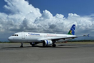
Honiara International Airport, formerly known as Henderson Field, is an airport in the province of Guadalcanal in the nation of Solomon Islands. It is the primary international airport in the country, the second being Munda Airport in Western Province, which serves as its alternate. It is located 8 kilometres from the capital, Honiara.
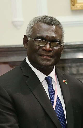
Manasseh Damukana Sogavare is a Solomon Islander politician serving as Minister of Finance since 2024. He served as the prime minister of Solomon Islands for a total of nine years from 2000–2001, 2006–2007, 2014–2017, and 2019–2024. Sogavare has served in the National Parliament representing East Choiseul since 1997.

The 2003–04 South Pacific cyclone season was a below-average season with only three tropical cyclones occurring within the South Pacific to the east of 160°E. The season officially ran from November 1, 2003 to April 30, 2004 with the first disturbance of the season forming on December 4 and the last disturbance dissipating on April 23. This is the period of the year when most tropical cyclones form within the South Pacific Ocean.

White River is a suburb on the fringe of Honiara, Solomon Islands and is located 3 kilometres (1.9 mi) west of the main center on the Tandai Highway. White River is in the Honiara City Council ward of Nggosi. A water spring supplies water to the community.

Honiara is the capital and largest city of Solomon Islands, situated on the northwestern coast of Guadalcanal. As of 2021, it had a population of 92,344 people. The city is served by Honiara International Airport and the seaport of Point Cruz, and lies along the Kukum Highway. In 1983, a capital territory – comprising the 22 square-kilometre metropolitan area of Honiara – was proclaimed, with a self-governing status akin to a province, although the city also retained an older role as capital of Guadalcanal Province.

The Royal Solomon Islands Police Force (RSIPF) is the national police force of Solomon Islands and in January 2015 had an establishment of approximately 1,153 officers and 43 police stations across the country.

The 1985–86 South Pacific cyclone season was an average tropical cyclone season, in terms of tropical cyclone formation, with ten tropical cyclones occurring within the basin between 160°E and 120°W. The season ran from February 5, 1985, to May 22, 1986, with tropical cyclones officially monitored by the Fiji Meteorological Service (FMS), Australian Bureau of Meteorology (BoM) and New Zealand's MetService. The United States Joint Typhoon Warning Center (JTWC) and other national meteorological services including Météo-France and NOAA also monitored the basin during the season. During the season there was nine tropical cyclones occurring within the basin, including three that moved into the basin from the Australian region.

Severe Tropical Cyclone Namu was considered to be one of the worst tropical cyclones to impact the Solomon Islands on record, after it caused over 100 deaths within the island nations. It was first noted as a weak tropical depression to the north of the Solomon Islands during May 15, 1986. Over the next couple of days, the storm steadily intensified while meandering. After briefly moving west, the storm attained Category 2 intensity on the Australian intensity scale on May 18, as it moved through the island chain on the next day. Cyclone Namu attained peak intensity of 150 km/h (90 mph). After retaining its peak intensity for a day, Namu turned south and weakened steadily. By May 21, the winds of Cyclone Namu had been reduced to only 80 km/h (50 mph). Continuing to weaken, Namu turned east and dissipated on May 22, away from the island chain.

Severe Tropical Cyclone Ita was the strongest tropical cyclone in the Australian region by central pressure since George in 2007, and by wind speed since Monica in 2006. The system was first identified over the Solomon Islands as a tropical low on 1 April 2014, and gradually moved westward, eventually reaching cyclone intensity on 5 April. On 10 April, Ita intensified rapidly into a powerful Category 5 system on the Australian Scale, but it weakened to a Category 4 system in the hours immediately preceding landfall the following day. At the time of landfall at Cape Flattery at 12 April 22:00 (UTC+10), the cyclone's Dvorak intensity was approximately T5.0, consistent with a weak Category 4 system, and considerably lower than the T6.5 observed when the system was at its peak intensity. Meteorologists noted the system had, at that time, begun an eyewall replacement cycle; as a result, the system was considerably less powerful than various intensity scales had predicted. As a result, Ita's impact on terrain was lessened.

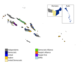
General elections were held in the Solomon Islands on 19 November 2014 to determine the composition of the 10th Parliament. The election was held following the passage of the Political Parties Integrity Bill, which sought to discourage party-switching. A biometric voter registration system was introduced before the election, which removed a large number of double enrolments and deceased voters from the electoral roll. Six of the twelve parties that contested the election won seats. The Democratic Alliance emerged as the largest, winning seven. Independents, who comprised the majority of candidates, won 32 of the 50 seats in the National Parliament. Only one woman was elected. Voter turnout was a record 89%. In an upset, Prime Minister Gordon Darcy Lilo lost his seat of Gizo/Kolombangara to his nephew Jimson Tanagada.
The Solomon Islands national rugby league team represents Solomon Islands in the sport of rugby league football. They are, in fact, planning a top-level tournament in 2010–11, after the capital of Honiara hosts an inter-city exhibition league, the Honiara Rugby League; expected in August 2009 but now it seems early 2010 will be the most convenient point for when it will be held after an uphold in the delivery of the participating teams jerseys caused delays. They are an unaffiliated nation and were recognised by the RLIF as having official observer status in early 2009. They are scheduled to participate in their first-ever test match against a touring New South Wales Police Team in November 2010.

Vuhokesa is a suburb in Honiara located in the main center on the Tandai Highway and includes the City Council roundabout. Vuhokesa is in the Honiara City Council ward of Vavaea. and is East of Point Cruz and West of Lord Howe Settlement. The Vuhokesa border is the West bank of the Mataniko River which runs into Kua Bay.

The Honiara Central Market is a fish, flower, clothing, fruit and vegetable market, which also sells shell money, and other local crafts such as palm-frond broomsticks, jewellery, coconut oil and hair tonics in Honiara, the capital of Solomon Islands; offering the largest fresh produce and fish outlets of the country. The market "dominates" the national internal trade, starting from early after its creation in the 1950s, and up until today.
General elections were held in Solomon Islands on 3 April 2019 to determine the composition of the 11th Parliament. The election was the first to occur since the conclusion of the Regional Assistance Mission to the Solomon Islands (RAMSI) in 2017. Parliament passed amendments to the electoral act in 2018 that included the introduction of pre-polling, a significant increase in campaign budgets for candidates and stricter penalties for individuals committing electoral offences such as vote-buying. Ten of the thirteen parties that contested the election won seats, and the Solomon Islands Democratic Party and the Kadere Party were the parties that secured the highest number, winning eight each. However, as in previous elections, independent candidates won the largest share of seats, securing 21.