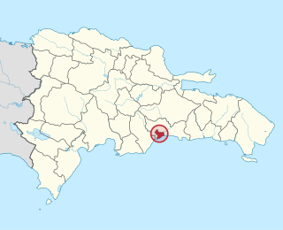
The Dominican Republic is divided into thirty–one provincias, while the national capital, Santo Domingo, is contained within its own Distrito Nacional.

The Distrito Nacional (D.N.) is a subdivision of the Dominican Republic enclosing the capital Santo Domingo. It is not in any of the provinces, but in practice, it acts as a province on its own. Before October 16, 2001, the Distrito Nacional was much larger, including what is now known as Santo Domingo Province. Published statistics and maps generally show the former, larger, Distrito Nacional. The Distrito Nacional has no rural or underdeveloped areas.
Carmen is the first distrito of San José Canton in Costa Rica, and one of the four administrative units that form San José downtown. This district is not heavily populated although it is a busy downtown area in daytime.
Merced is a district of the San José canton, in the San José province of Costa Rica. It is one of the four administrative units that form San José downtown properly. This division is merely commercial, but covers an important part of "josefino" life and activities.
Hospital is a district of the San José canton, in the San José province of Costa Rica. It is one of the four administrative units that form San José downtown properly. The district houses, along with Merced district, the main commercial activity of the city, and is the most populous of the four central districts.
Catedral is a district of the San José canton, in the San José province of Costa Rica, it is one of the four administrative units that form San José downtown properly.

Zapote the fifth district of the San José canton, in the San José province of Costa Rica. It is one of the administrative units surrounding San José downtown. The district is primarily residential, although there are some government buildings, standing out the Presidential House, seat of the government.
San Francisco de Dos Ríos is the sixth district of the San José canton, in the San José province of Costa Rica. It is one of the administrative units surrounding San José downtown. The district is primarily residential and industrial. It's also famous for the numerous motels between its boundaries.
Uruca is the seventh district of the San José canton, in the San José province of Costa Rica. It is an important industrial and commercial area of San José. Commonly known as La Uruca, it's the second biggest district by area, and recognized as a heavily congested transportation hub.
Mata Redonda is a district of the San José canton, in the San José province of Costa Rica.

Pavas is the ninth district of the San José canton, in the San José province of Costa Rica. The district comprises Tobías Bolaños International Airport, San José's domestic airport.
Hatillo is the tenth district of the San José canton, in the San José province of Costa Rica.
San Sebastián is the eleventh district of the San José canton, in the San José province of Costa Rica. An important residential district, San Sebastián is the third most populated and second most densely populated in the canton.
30 de Mayo is a neighbourhood in the city of Santo Domingo in the Distrito Nacional of the Dominican Republic. This neighbourhood is populated in particular by individuals from the middle classes.
Altos de Arroyo Hondo is a neighbourhood in the city of Santo Domingo in the Distrito Nacional of the Dominican Republic. This neighbourhood is populated in particular by individuals from the upper middle and upper classes.
Arroyo Manzano is a neighbourhood in the city of Santo Domingo in the Distrito Nacional of the Dominican Republic. This neighbourhood is populated in particular by individuals from the middle class.
Atala is a sector or neighbourhood in the city of Santo Domingo in the Distrito Nacional of the Dominican Republic. This neighborhood is in particular populated by individuals from the upper middle class.
Cristo Rey is a sector in the city of Santo Domingo in the Distrito Nacional of the Dominican Republic. The neighbourhood is populated by the lower middle class. This heavily populated area was formed in the last major resettlement for industrious peasants mostly coming from the North of the country, especially around 1970–1974, when the National Zoo was built on the Arroyo Riverside.
Villa Consuelo is a neighbourhood in the city of Santo Domingo in the Distrito Nacional of the Dominican Republic. This neighbourhood is populated in particular by individuals from the lower middle class.
This page is based on this
Wikipedia article Text is available under the
CC BY-SA 4.0 license; additional terms may apply.
Images, videos and audio are available under their respective licenses.


