The 27th meridian west from Washington is an archaic meridian based on the Washington Meridian. The meridian is approximately 104 degrees west of the Prime Meridian. [1] It is used as the boundary of five states of the United States.
The 27th meridian west from Washington is an archaic meridian based on the Washington Meridian. The meridian is approximately 104 degrees west of the Prime Meridian. [1] It is used as the boundary of five states of the United States.
After the completion of the first transcontinental railroad in the United States on May 10, 1869, Robert R. Livingston, the Iowa and Nebraska Surveyor General, on May 29, 1869, hired Oliver N. Chaffee, a surveyor and astronomer from Detroit, Michigan, to survey the 25th and 27th meridians west of Washington, D.C. [2] Chaffee traveled to the eastern terminus of the Union Pacific Railroad at Omaha, Nebraska, where he met with the newly established astronomical station built by the United States Coast Survey. From there, he went to Bushnell, Nebraska, where he took astronomical readings for two days to coordinate with Omaha. Chaffee then placed a second astronomical station in Julesburg, Colorado, and traveled east to connect the 25th and 27th meridians with the 41st parallel, which formed the boundaries or corners of five western states. [3]
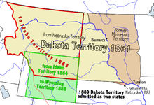
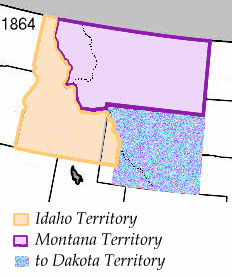
The use of the meridian as a boundary began in 1863 when the Idaho Territory was created, with the 27th meridian as its eastern boundary. [4] At that time, the Dakota Territory and the Nebraska Territory gained their western boundary as portions of those territories were made a part of Idaho Territory. Nebraska became a state in 1867. [5] In 1868, the Wyoming Territory was created with the meridian as its eastern boundary. [6] The Dakota Territory was divided into North Dakota and South Dakota when they became states on November 2, 1889, and Montana became a state just six days later. [7] [8] Wyoming became a state in 1890. [9] The Montana-North Dakota, Montana-South Dakota, Wyoming-South Dakota, and Wyoming-Nebraska state borders therefore are all defined by the 27th meridian west from Washington. [10]
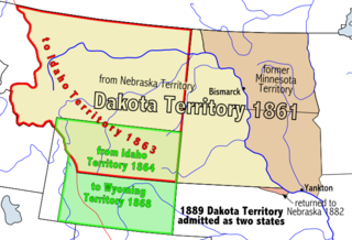
The Territory of Dakota was an organized incorporated territory of the United States that existed from March 2, 1861, until November 2, 1889, when the final extent of the reduced territory was split and admitted to the Union as the states of North and South Dakota.
The Territory of Washington was an organized incorporated territory of the United States that existed from March 2, 1853, until November 11, 1889, when the territory was admitted to the Union as the State of Washington. It was created from the portion of the Oregon Territory north of the lower Columbia River and north of the 46th parallel east of the Columbia. At its largest extent, it also included the entirety of modern Idaho and parts of Montana and Wyoming, before attaining its final boundaries in 1863.

The Territory of Wyoming was an organized incorporated territory of the United States that existed from July 25, 1868, until July 10, 1890, when it was admitted to the Union as the State of Wyoming. Cheyenne was the territorial capital. The boundaries of the Wyoming Territory were identical to those of the modern State of Wyoming.

The Territory of Idaho was an organized incorporated territory of the United States that existed from March 3, 1863, until July 3, 1890, when the final extent of the territory was admitted to the Union as Idaho.

The Territory of Montana was an organized incorporated territory of the United States that existed from May 26, 1864, until November 8, 1889, when it was admitted as the 41st state in the Union as the state of Montana.

The Territory of Nebraska was an organized incorporated territory of the United States that existed from May 30, 1854, until March 1, 1867, when the final extent of the territory was admitted to the Union as the state of Nebraska. The Nebraska Territory was created by the Kansas–Nebraska Act of 1854. The territorial capital was Omaha. The territory encompassed areas of what is today Nebraska, Wyoming, South Dakota, North Dakota, Colorado, and Montana.

The Mountain Time Zone of North America keeps time by subtracting seven hours from Coordinated Universal Time (UTC) when standard time (UTC−07:00) is in effect, and by subtracting six hours during daylight saving time (UTC−06:00). The clock time in this zone is based on the mean solar time at the 105th meridian west of the Greenwich Observatory. In the United States, the exact specification for the location of time zones and the dividing lines between zones is set forth in the Code of Federal Regulations at 49 CFR 71.

The territory of the United States and its overseas possessions has evolved over time, from the colonial era to the present day. It includes formally organized territories, proposed and failed states, unrecognized breakaway states, international and interstate purchases, cessions, and land grants, and historical military departments and administrative districts. The last section lists informal regions from American vernacular geography known by popular nicknames and linked by geographical, cultural, or economic similarities, some of which are still in use today.

The National Register of Historic Places in the United States is a register including buildings, sites, structures, districts, and objects. The Register automatically includes all National Historic Landmarks as well as all historic areas administered by the U.S. National Park Service. Since its introduction in 1966, more than 90,000 separate listings have been added to the register.

Lincoln is the name for several proposals to create a new state in the Northwest United States. The proposed State has been defined in multiple ways, but can generally be said to be coterminous with the region known as the Inland Northwest. The proposed state was named in honor of Abraham Lincoln, who was president during the American Civil War. His name had also been proposed for the states that were eventually named North Dakota and Wyoming.
Dakota Territory's at-large congressional district is an obsolete congressional district that encompassed the entire Dakota Territory prior to admission to the Union. The district elected a delegate to the United States Congress.
The meridian 104° west of Greenwich is a line of longitude that extends from the North Pole across the Arctic Ocean, North America, the Pacific Ocean, the Southern Ocean, and Antarctica to the South Pole.

The 25th meridian of longitude west from Washington is a line of longitude approximately 102.05 degrees west of the Prime Meridian of Greenwich. In the United States of America, the meridian 25 degrees west of the Washington Meridian defines the eastern boundary of the State of Colorado, the western boundary of the State of Kansas, and the western boundary of the State of Nebraska south of the 41st parallel north.
The Department of the Platte was a military administrative district established by the U.S. Army on March 5, 1866, with boundaries encompassing Iowa, Nebraska, Dakota Territory, Utah Territory and a small portion of Idaho. With headquarters in Omaha, the district commander oversaw the army's role initially along the Overland route to Salt Lake City, then later the construction route of the Union Pacific Railroad. The district also included the Montana road through eastern Wyoming. The district was discontinued when the Army's command was reorganized in 1898.

The following is an alphabetical list of articles related to the U.S. state of Wyoming.

The history of Idaho in the American Civil War is atypical, as the territory was far from the battlefields.
The area that eventually became the U.S. state of Montana played little direct role in the American Civil War. The closest the Confederate States Army ever came to the area was New Mexico and eastern Kansas, each over a thousand miles away. There was not even an organized territory using "Montana" until the Montana Territory was created on May 26, 1864, three years after the Battle of Fort Sumter. In 1861, the area was divided between the Dakota Territory and the Washington Territory, and in 1863, it was part of the Idaho Territory.

The 1763 Treaty of Paris ended the major war known by Americans as the French and Indian War and by Canadians as the Seven Years' War / Guerre de Sept Ans, or by French-Canadians, La Guerre de la Conquête. It was signed by Great Britain, France and Spain, with Portugal in agreement. Preferring to keep Guadeloupe, France gave up Canada and all of its claims to territory east of the Mississippi River to Britain. With France out of North America this dramatically changed the European political scene on the continent.
The 34th meridian west from Washington is an archaic meridian based on the Washington Meridian and hence 111°2′48.0″ West of Greenwich. The meridian is most notably used as a boundary for four states. The east-west continental divide of North America crosses the 34th meridian at the tripoint between Idaho, Montana and Wyoming.
The 39th meridian west from Washington is an archaic meridian based on the Washington meridian. The meridian is currently used as a boundary for two states.
{{cite web}}: CS1 maint: unfit URL (link)