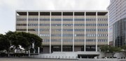
 View from Temple Street
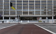 Front entrance
 Lobby
Lobby Recognition of All Foreign Lands by Richard Haines
Federal Building | |
 Federal Building in 2016 | |
   | |
| Location | 300 N Los Angeles St., Los Angeles, California |
|---|---|
| Coordinates | 34°03′14″N118°14′25″W / 34.05390°N 118.24014°W |
| Built | 1965 |
| Architectural style | Modern |
| NRHP reference No. | 100006288 |
| Added to NRHP | March 9, 2021 |
The 300 North Los Angeles Street Federal Building, located across the street from the Edward R. Roybal Federal Building and United States Courthouse, is a federal building of the United States that opened in 1965 and is now on the National Register of Historic Places. [1] [2] The building is also notable as the site of a 1971 bombing that killed an 18-year-old worker. [3]
Contents
The building holds offices for a number of federal agencies, including the U.S. Immigration and Customs Enforcement, U.S. Citizenship and Immigration Services, and the Internal Revenue Service. [4]


