
Pahang officially Pahang Darul Makmur with the Arabic honorific Darul Makmur is a sultanate and a federal state of Malaysia. It is the third largest Malaysian state and the largest state in peninsular by area, and ninth largest by population. The state occupies the basin of the Pahang River, and a stretch of the east coast as far south as Endau. Geographically located in the East Coast region of the Peninsular Malaysia, the state shares borders with the Malaysian states of Kelantan and Terengganu to the north, Perak, Selangor and Negeri Sembilan to the west, Johor to the south, while South China Sea is to the east. The Titiwangsa mountain range that forms a natural divider between the Peninsula's east and west coasts is spread along the north and south of the state, peaking at Mount Tahan, which is 2,187 metres (7,175 ft) high & the famous Kuantan 188 which is 188 metres (617 ft) high. Although two thirds of the state is covered by dense rain forest, its central plains are intersected by numerous rivers, and along the coast there is a 32-kilometre (20 mi) wide expanse of alluvial soil that includes the deltas and estuarine plains of the Kuantan, Pahang, Rompin, Endau, and Mersing rivers.

Sultan Haji Ahmad Shah Al-Musta’in Billah ibni Almarhum Sultan Abu Bakar Ri’ayatuddin Al-Mu’azzam Shah was the fifth modern Sultan of Pahang, and also served as the seventh Yang di-Pertuan Agong of Malaysia from 26 April 1979 to 25 April 1984. His abdication as Sultan was decided by the Royal Council at an extraordinary meeting on 11 January 2019. A special amendment was passed on the state constitution that gave the body more power for this decision, citing the Sultan's incapability to rule due to his failing health. The abdication announced the next day which was retroactively effective on the day of the Royal Council meeting, paving the way to his son, Abdullah to succeed him as Sultan immediately, and subsequently be elected as the next Yang di-Pertuan Agong later the same month.

Tengku Ampuan Hajah Afzan Rahimahallah binti Almarhum Tengku Panglima Perang Tengku Muhammad 4 December 1932 – 29 June 1988) was the Tengku Ampuan of Pahang. She served as Raja Permaisuri Agong of Malaysia between 26 April 1979 and 25 April 1984.
Sultan Abu Bakar Ri’ayatuddin Al-Mu’azzam Shah Ibni Al-Marhum Sultan Abdullah Al-Mu’tassim Billah Shah, was the fourth modern Sultan of Pahang.

Kuantan is a city and the state capital of Pahang, Malaysia. It is located near the mouth of the Kuantan River. Kuantan is the 18th largest city in Malaysia based on 2010 population, and the largest city in the East Coast of Peninsular Malaysia.
Pekan Town is a town in Pekan District, Pahang, Malaysia. It is also the royal capital of the state. Its name comes from a flower, the Bunga Pekan. Pekan is also the name of the district the town is situated in, and a parliamentary constituency in its own right. It is the home of the state's royal family headed by Sultan Abdullah of Pahang. It is also the hometown of the second Prime Minister of Malaysia, Tun Abdul Razak Hussein, and his son, former prime minister Datuk Seri Najib Razak. Najib is also Pekan's current Member of Parliament.

The Pahang River is a river that flows through the state of Pahang, Malaysia. At 459 km in length, it is the longest river on the Malay Peninsula. The river begins at the confluence of Jelai and Tembeling rivers on the Titiwangsa Mountains and drains into the South China Sea.
The Federal Route 2 is a major east–west oriented federal highway in Malaysia. The 276.9 kilometres (172 mi) road connects Port Klang in Selangor to Kuantan Port in Pahang. The Federal Route 2 became the backbone of the road system linking the east and west coasts of Peninsula Malaysia before being surpassed by the East Coast Expressway E8.
Federal Route 3 is a main federal road running along the east coast of Peninsula Malaysia. The 739 kilometres (459 mi) federal highway connects Rantau Panjang in Kelantan until Johor Bahru in Johor. The entire FT3 highway is gazetted as a part of the Asian Highway Network route 18.
Tun Razak Highway, Federal Route 12(Lebuhraya Tun Razak), also known as Segamat-Kuantan Highway(Lebuhraya Segamat-Kuantan), Asian Highway Route 142, is a 146.8 kilometres (91 mi) federal highway running from the town of Segamat, Johor to Gambang before proceeding another 38 kilometres (24 mi) via Federal Route 2 to Gambang near Kuantan, Pahang. This two-lane federal road is named in honor of Tun Abdul Razak, Malaysia's second Prime Minister which was known as Malaysia's Father of Development. The highway is part of the Asian Highway Network of route 142.

The Sultan Ismail Bridge is a bridge in Muar town across the Muar River in Johor, Malaysia. It was the first bridge built across a river that connects Bandar Maharani, Muar to Tanjung Agas which is now named as part of Tangkak district. The bridge replaced old ferry services in the 1960s. The bridge was originally a toll bridge making the second toll bridge in Malaysia after Sultan Yahya Petra Bridge in Kelantan.

The Abu Bakar Royal Mosque is Pahang's royal mosque which is located in Pekan, Pahang, Malaysia. It was officially opened in 1976 by Sultan Ahmad Shah of Pahang replacing the nearby Abdullah Mosque or Old Royal Mosque.

Tanjung Sepat or better known as Pantai Sepat is a typical Malay fishing village located in Kuantan District, Pahang, Malaysia. From Kuantan, it is accessible via Jalan Abu Bakar Federal Route 183 and is an alternative way to the royal town of Pekan.
Tanjung Lumpur is a traditional fishing village located near the mouth of the Kuantan river in Kuantan District, Pahang, Malaysia. It is loosely translated into English as the " Cape of Mud". This village was in fact one of the earliest villages opened by the Malays in Kuantan many decades ago. It is located in the district of Kuantan about 2 kilometers away from Kuantan city. Tanjung Lumpur and Kuantan is divided by Kuantan river at the middle and connected by a bridge Federal Route 183. Tanjung Lumpur is well known for its ikan bakar. Tanjung Lumpur now rapidly develop with the new infrastructure such as Swiss-Belhotel Kuantan, KPJ Kuantan and Serambi Teruntum.

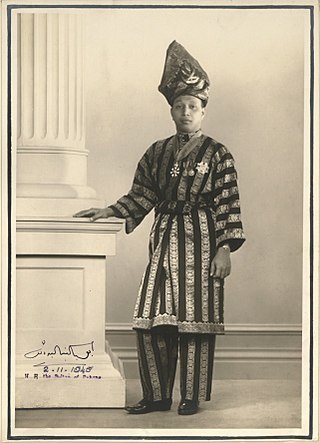
Al-Sultan Abdullah Ri'ayatuddin Al-Mustafa Billah Shah ibni Almarhum Sultan Haji Ahmad Shah Al-Musta'in Billah has reigned as the 16th Yang di-Pertuan Agong (King) of Malaysia and the 6th Sultan of Pahang since January 2019. He was proclaimed as sultan on 15 January 2019, succeeding his father, Sultan Ahmad Shah, whose abdication was decided at a Royal Council meeting on 11 January 2019.

The Sultan Abdul Halim Muadzam Shah Bridge or Penang Second Bridge Sultan Abdul Halim Muadzam Shah Bridge is a dual carriageway toll bridge in Penang, Malaysia. It connects Bandar Cassia in Seberang Perai on mainland Peninsular Malaysia with Batu Maung on Penang Island. It is the second bridge to link the island to the mainland after the first Penang Bridge.
Sultan ʽAbdullah Al-Muʽtassim Billah Shah Ibni Al-Marhum Sultan Ahmad Al-Muʽazzam Shah was the third modern Sultan of Pahang who ruled from 1917 to 1932.
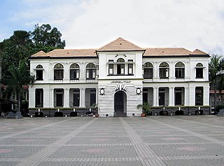
The Sultan Abu Bakar Museum is a museum in Pekan, Pahang, Malaysia. It showcases the native people relics found in the country.
Yaakub Isa was a Malaysian teacher, writer, scholar of the Malay language and literature.

Kuala Terengganu Drawbridge is a bascule bridge in Kuala Terengganu, Terengganu, Malaysia, which crosses the mouth of Terengganu River. The bridge is the fourth bridge in Kuala Terengganu City area that straddles the river after Sultan Mahmud Bridge, Manir Bridge, and Pulau Sekati Bridge.
