Acha, Coll

Last updated

Acha
Acha Mill.jpg
Acha Mill, a disused and converted watermill
Argyll and Bute UK location map.svg
Red pog.svg
Acha
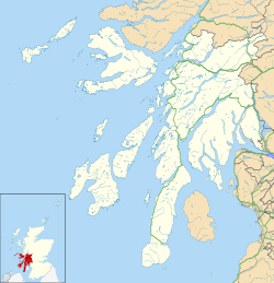
Location within Argyll and Bute
OS grid reference NM1854
Council area
Lieutenancy area
Country Scotland
Sovereign state United Kingdom
Post town ISLE OF COLL
Postcode district PA78
Police Scotland
Fire Scottish
Ambulance Scottish
UK Parliament
Scottish Parliament
List of places
UK
Scotland
56°35′56″N6°35′20″W / 56.599°N 6.589°W / 56.599; -6.589 Coordinates: 56°35′56″N6°35′20″W / 56.599°N 6.589°W / 56.599; -6.589

Acha (Gaelic: An t-Achadh, tranlsating to "The Field") is a small hamlet on the Scottish island of Coll. [1]
Contents

Climate

Climate in Acha tends to be cold.

Related Research Articles

<span class="mw-page-title-main">River Test</span> River in Hampshire, England

The River Test is a chalk stream in Hampshire in the south of England. It rises at Ashe near Basingstoke and flows southwards for 40 miles (64 km) to Southampton Water. Settlements on the Test include the towns of Stockbridge and Romsey. Below the village of Longparish, the river is broadly followed by the Test Way, a long-distance footpath.

<span class="mw-page-title-main">Coll</span> Island and parish in the Inner Hebrides, Scotland

Coll is an island located west of the Isle of Mull in the Inner Hebrides of Scotland. Coll is known for its sandy beaches, which rise to form large sand dunes, for its corncrakes, and for Breacachadh Castle. It is in the council area of Argyll and Bute.

The Treshnish Isles are an archipelago of small islands and skerries, lying west of the Isle of Mull, in Scotland. They are part of the Inner Hebrides. Trips to the Treshnish Isles operate from Ulva Ferry, Tobermory, Ardnamurchan and Tiree.

<span class="mw-page-title-main">Cabinteely</span> Suburb of Dublin, Ireland

Cabinteely is a suburb of Dublin's southside. It is in Dún Laoghaire–Rathdown, County Dublin, Ireland.

<span class="mw-page-title-main">Dunadry</span> Human settlement in Northern Ireland

Dunadry is a hamlet and townland 3 miles (5 km) from Antrim in County Antrim, Northern Ireland. It is situated in the civil parish of Grange of Nilteen and the historic barony of Antrim Upper. It is within the Antrim and Newtownabbey Borough Council area. It had a population of 430 people in the 2011 Census..

<span class="mw-page-title-main">Dunbeg</span> Human settlement in Scotland

Dunbeg, formerly known as Dunstaffnage, is a village about 2+12 miles (4 km) outside of Oban, Scotland. It has a population of just under 1,000. It is home to the Scottish Association for Marine Science (SAMS), one of the primary marine science centres in the UK. Also near Dunbeg is Dunstaffnage Castle, part of the Campbell Clan and is owned by the Captain of Dunstaffnage.

<span class="mw-page-title-main">West Barns</span> Human settlement in Scotland

West Barns is a small village in East Lothian, Scotland. It lies 2 miles west of Dunbar and approximately 28 miles east of Edinburgh. It is close to John Muir Country Park and Belhaven Bay. For many years, it was home to the West Barns Inn and is still home to the West Barns Bowling Club. It was home to a major John Deere farm machinery dealership, that moved to Haddington in 2017, the site being taken over by the Thistly Cross Cider Company. There is also a local amateur football team, West Barns Star. Children of primary-school age attend West Barns Primary, after which they will go to Dunbar Grammar School.

Dunalastair is an estate in the southern part of the Highlands, in Perthshire, Scotland. It is 18 miles west of the town of Pitlochry, lying along the River Tummel between Tummel Bridge to the east and Kinloch Rannoch to the west, and incorporates part of Dunalastair Loch/Reservoir.

Eden Water is a tributary of the River Tweed in the Scottish Borders of Scotland. "Water" is the Lowland Scots term for a small river.

Dùn Chonnuill is a small island in the Garvellachs in the Firth of Lorn, Scotland.

<span class="mw-page-title-main">Two Rock</span>

Two Rock is a mountain in Dún Laoghaire–Rathdown, Ireland. It is 536 metres high and is the 382nd highest mountain in Ireland. It is the highest point of the group of hills in the Dublin Mountains which comprises Two Rock, Three Rock, Kilmashogue and Tibradden Mountains. The mountain takes its name from the two granite tors that lie to the south-east of the summit. From the summit, which is called Fairy Castle, there are views of much of the Dublin area from Tallaght to Howth to the north while Bray Head, Killiney Hill, the Great Sugar Loaf and the Wicklow Mountains are visible to the south. The summit area is mostly shallow bog while ferns and gorse cover the lower slopes. The mountain is also an important habitat for red grouse.

Middle Ord is a small hamlet, between West Ord and East Ord, and west of the town of Berwick upon Tweed, Northumberland England. The population as of March 2008, is nineteen residents within seven dwellings, centered on Middle Ord Manor House.

<span class="mw-page-title-main">Dùn Anlaimh</span>

Dùn Anlaimh, also known as Dùn Amhlaidh, and Eilean nan Cinneachan, is a crannog, located within Loch nan Cinneachan on the Inner Hebridean island of Coll. Upon the crannog there are the remains of walls and several buildings. These remains are not unlike those of other fortified islands found throughout the Outer Hebrides, and it is likely that Dùn Anlaimh dates from the late Middle Ages. According to local tradition on Coll, the fort was once the home of a Norse chieftain who was defeated in battle somewhere nearby. The early 20th century antiquary Erskine Beveridge considered it as one of the four most interesting fortifications, on Coll. The site of Dùn Anlaimh is located at grid reference NM18845684. The RCAHMS classifies the site as a 'crannog' and an 'island dwelling'.

<span class="mw-page-title-main">Dùn an Achaidh</span>

Dùn an Achaidh, sometimes Anglicised as Dun Acha, is a dun located near the village of Acha on the Inner Hebridean island of Coll. It is considered the best preserved dun on the island. The site of Dùn an Achaidh is located at grid reference NM18335456. According to local tradition, the dun was the stronghold of, and named after, the son of a Norse king. The early 20th century antiquary Erskine Beveridge considered it as one of the four most interesting fortifications on Coll.

<span class="mw-page-title-main">Dùn Dubh</span>

Dùn Dubh is a hillfort, located on the Inner Hebridean island of Coll. The fort is one of three associated with a local tradition which states that they were once the fortresses of Norsemen before being defeated by a Maclean chieftain. The early 20th century antiquary Erskine Beveridge considered it as one of the four most interesting fortifications, on Coll. The site is located at grid reference NM18365942.

<span class="mw-page-title-main">Dùn Morbhaidh</span>

Dùn Morbhaidh, also known as Dun Borbaidh, is a hill fort located on the Inner Hebridean island of Coll. The early 20th century antiquary Erskine Beveridge considered it as one of the four most interesting fortifications on Coll. The site is located at grid reference NM23456331.

<span class="mw-page-title-main">Dùn Beic</span> Dun located on the Inner Hebridean island of Coll

Dùn Beic is a dun located on the Inner Hebridean island of Coll. It is located at grid reference NM15495644 and is thought to date to between 1000 BCE to 1000 CE. The etymology of the dun's name is uncertain; one possibility is that it could be made up of a personal name. The dun appears in local legend as being one of several fortresses held by Norsemen, who were defeated in battle against the ancestor of the Macleans of Coll. There have been several archaeological finds at Dùn Beic; these include pieces of flint, burnt bone, and fragments of incised pottery.

An Caisteal is a hill fort located on the island of Coll. This island is one of the islands which make up the Inner Hebrides located on the west coast of Scotland. The fort is located at grid reference NM17185815. Located 1,200 yards (1.1 km) to the north-east of An Caisteal is Dùn Foulag. Dùn Foulag, located at grid reference NM17505908, was once thought to be a dun, though it is now considered to be only a naturally rocky knoll.

Dun is a rural parish in Angus, Scotland. It contains the House of Dun, home of the Erskine family and is a stop on the Caledonian Railway. It is located on the river South Esk, west of Montrose and east of Brechin. In 1785-7 a bridge was built there across the South Esk. The writer Violet Jacob was born at the House of Dun. William Chalmers Burns, a famous Scottish evangelist was born at Dun in 1815.

References

  1. Ordnance Survey: Landranger map sheet 46 Coll & Tiree (Map). Ordnance Survey. 2014. ISBN   9780319229743.

See also