
The Canterbury Plains are an area in New Zealand centred in the Mid Canterbury, to the south of the city of Christchurch in the Canterbury region. Their northern extremes are at the foot of the Hundalee Hills in the Hurunui District, and in the south they merge into the plains of North Otago beyond the Waitaki River. The smaller Amuri Plain forms a northern extension of the plains.
Selwyn is a village in the Selwyn District of Canterbury, New Zealand. It was laid out in the 1860s for a population of 2,000 people, but it currently has very few houses.

Rakaia is a town sited on the southern banks of the Rakaia River on the Canterbury Plains in New Zealand's South Island, approximately 57 km south of Christchurch on State Highway 1 and the Main South Line. Immediately north of the township are New Zealand's longest road bridge and longest rail bridge, both of which cross the wide shingle beds of the braided river at this point. Both bridges are approximately 1,750 metres (5,740 ft) in length.

The Rakaia River is in the Canterbury Plains in New Zealand's South Island. The Rakaia River is one of the largest braided rivers in New Zealand. The Rakaia River has a mean flow of 203 cubic metres per second (7,200 cu ft/s) and a mean annual seven-day low flow of 87 m3/s (3,100 cu ft/s). In the 1850s, European settlers named it the Cholmondeley River, but this name lapsed into disuse. The name Rakaia comes from Māori "Ō Rakaia", meaning the place where people were arranged by ranks.
The Waimakariri Gorge is located on the Waimakariri River in inland Canterbury in the South Island of New Zealand.

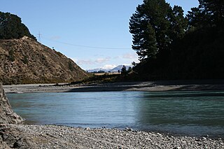
The Rakaia Gorge is located on the Rakaia River in inland Canterbury in New Zealand's South Island.

The Main North Line between Picton and Christchurch and the Main South Line between Lyttelton and Invercargill, running down the east coast of the South Island of New Zealand, are sometimes together referred to collectively as the South Island Main Trunk (SIMT). Construction of a line running the length of the east coast began in the 1860s and was completed all the way from Picton to Invercargill in 1945; the last sections being on the Main North Line south of Picton. The designation "South Island Main Trunk" originally referred to only that line between Christchurch and Invercargill.
The Main South Line, sometimes referred to as part of the South Island Main Trunk Railway, is a railway line that runs north and south from Lyttelton in New Zealand through Christchurch and along the east coast of the South Island to Invercargill via Dunedin. It is one of the most important railway lines in New Zealand and was one of the first to be built, with construction commencing in the 1860s. At Christchurch, it connects with the Main North Line to Picton, the other part of the South Island Main Trunk.
The Methven Branch was a branch line railway that was part of New Zealand's national rail network in Canterbury. It opened in 1880 and operated until 1976.

The Whitecliffs Branch was an 18.4 kilometres (11.4 mi) long branch line railway that formed part of New Zealand's national rail network in the Canterbury region of the South Island. It was more industrial than the many rural branches on the South Island's east coast whose traffic primarily derived from agriculture, and it operated from 1875 until 1962.

Lake Lyndon is a small lake in the Canterbury region of New Zealand's South Island. It is located near Porters Pass on State Highway 73 after Springfield heading into the Southern Alps. The lake regularly freezes in winter due to its elevation and location on the outer border of the Southern Alps.

Coalgate is a small town in the Selwyn District of the Canterbury region of New Zealand's South Island. It is located roughly an hour west of Christchurch on State Highway 77. The town's name stems from it being the "gateway" to the lignite coal fields around Whitecliffs, the Rakaia Gorge, and The Acheron River. Coal mining declined in the 20th century and has now ceased, but since the 1950s, commercial processing of nontronite has taken place in Coalgate.
The Papahaua Range is a mountain range on the West Coast of New Zealand's South Island east of the town of Westport. It is a geological continuation of the Paparoa Range that is south of the Buller River and it runs north from the Buller Gorge to the Mōkihinui River. At its north end, it meets the Glasgow Range.
Longbeach is a lowly populated locality in the Canterbury region of New Zealand's South Island. It is located in a rural area of the Canterbury Plains on the shore of the Pacific Ocean on the northern side of the Hinds River's mouth.

The Seddonville Branch, later truncated as the Ngākawau Branch, is a branch line railway in the West Coast region of New Zealand's South Island. Construction began in 1874 and it reached its terminus at the Mokihinui Mine just beyond Seddonville in 1895. In 1981 it was closed past Ngākawau and effectively became an extension of the Stillwater–Westport Line, since formalised as the Stillwater–Ngākawau Line.
The Conns Creek Branch was a 2.7 kilometre branch line railway in the West Coast region of New Zealand's South Island. It diverged from the Seddonville Branch at Waimangaroa and followed the southern bank of the Waimangaroa River to the line's terminus at Conns Creek at the foot of the Denniston Incline. The line operated from 1877 until 1967 and existed for the sole purpose of conveying coal from mines to the port of Westport.

The Tasman Region, and the small adjoining Nelson Region, form one of the more geologically interesting regions of New Zealand. It contains the oldest rocks of anywhere on New Zealand's main islands. It contains all the main terranes that make up New Zealand's basement. These basement rocks include Ultramafic rocks, such as Serpentine and Dunite, and valuable minerals, such as Gold. The Nelson Region is bordered to the south by the Alpine Fault, the main fault forming the boundary between the Pacific Plate and the Indo-Australian Plate, that generated the Southern Alps.

The NZR Q class were a pair of 2-4-4T type tank engines built by Rogers Locomotive and Machine Works in New Jersey. They were similar, in appearance, to the earlier K class of the same manufacturer and were purchased by the Rakaia & Ashburton Forks Railway Company for working their newly constructed railway to Methven from Rakaia, which later became the Methven Branch.

Barrhill is a lightly populated locality in the Canterbury region of New Zealand's South Island. It is situated on the Canterbury Plains, on the right bank of the Rakaia River, about 17 kilometres (11 mi) inland from Rakaia. It was founded by Cathcart Wason in the mid-1870s and named by him after his old home Barrhill in South Ayrshire, Scotland. Wason set it up as a model village for the workers of his large sheep farm. The population of the village peaked in the mid-1880s before the general recession initiated a downturn for the village. Wason had expected for the Methven Branch railway to run past Barrhill, but the line was built in 1880 on an alignment many miles away, which caused Barrhill population to decrease.


