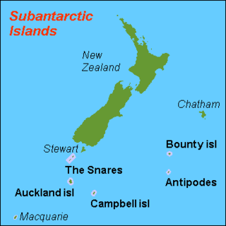
The Auckland Islands are an archipelago of New Zealand, lying 465 km (289 mi) south of the South Island. The main Auckland Island, occupying 460 km2 (180 sq mi), is surrounded by smaller Adams Island, Enderby Island, Disappointment Island, Ewing Island, Rose Island, Dundas Island, and Green Island, with a combined area of 570 km2 (220 sq mi). The islands have no permanent human inhabitants.

Auckland Island is the main island of the eponymous uninhabited archipelago in the Pacific Ocean. It is part of the New Zealand subantarctic area. It is inscribed in the UNESCO World Heritage list together with the other New Zealand Subantarctic Islands in the region.

Campbell Island / Motu Ihupuku is an uninhabited subantarctic island of New Zealand, and the main island of the Campbell Island group. It covers 112.68 square kilometres (43.51 sq mi) of the group's 113.31 km2 (43.75 sq mi), and is surrounded by numerous stacks, rocks and islets like Dent Island, Folly Island, Isle de Jeanette-Marie, and Jacquemart Island, the latter being the southernmost extremity of New Zealand. The island is mountainous, rising to over 500 metres (1,640 ft) in the south. A long fiord, Perseverance Harbour, nearly bisects it, opening out to sea on the east coast.

The Snares Islands, known colloquially as The Snares, is a group of uninhabited islands lying about 200 km (120 mi) south of New Zealand's South Island and to the south-southwest of Stewart Island / Rakiura. The Snares consist of the main North East Island and the smaller Broughton Island and Alert Stack, as well as the Western Chain Islands some 5 km (3.1 mi) to the west-southwest. Collectively, the Snares have a total land area of 3.4 km2 (1.3 sq mi).

The New Zealand Subantarctic Islands comprise the five southernmost groups of the New Zealand outlying islands. They are collectively designated as a UNESCO World Heritage Site.

Penguin Island is one of the smaller of the South Shetland Islands of Antarctica.
Cormorant Island is a 10 ha island lying in Bismarck Strait 1 km south of Anvers Island, 4 km (2.5 mi) east-south-east of Bonaparte Point, in the Palmer Archipelago of Antarctica. It lies some 5 km to the south-east of the United States' Palmer Station in Arthur Harbour on Anvers Island. It was shown on an Argentine government chart of 1954, but not named. It was named by the United Kingdom Antarctic Place-names Committee (UK-APC) in 1958 because of the large number of cormorants (shags) seen there.

Litchfield Island is a rocky island 0.9 kilometres (0.5 nmi) long and rising to 50 m (164 ft), lying in Arthur Harbour, 0.9 kilometres (0.5 nmi) south of Norsel Point, off the south-west coast of Anvers Island in the Palmer Archipelago of Antarctica.

The Campbell Islands are a group of subantarctic islands, belonging to New Zealand. They lie about 600 km south of Stewart Island. The islands have a total area of 113 km2 (44 sq mi), consisting of one big island, Campbell Island, and several small islets, notably Dent Island, Isle de Jeanette Marie, Folly Island, Jacquemart Island, and Monowai Island. Ecologically, they are part of the Antipodes Subantarctic Islands tundra ecoregion. The islands are one of five subantarctic island groups collectively designated as a World Heritage Site by UNESCO.

Enderby Island is part of New Zealand's uninhabited Auckland Islands archipelago, south of mainland New Zealand. It is situated just off the northern tip of Auckland Island, the largest island in the archipelago.

Ewing Island is an uninhabited island, part of the Auckland Islands group, a subantarctic chain that forms part of the New Zealand outlying islands. It lies in the north-east of the group, close to the mouth of Port Ross, immediately to the south of the larger Enderby Island and off the north-eastern tip of the main Auckland Island.

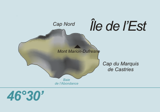
Île de l'Est, or East Island, is a part of the subantarctic archipelago of the Crozet Islands. With an area of 130 km2 (50 sq mi) it is the second largest island of the group. It is part of the French Southern and Antarctic Lands.

Disappointment Island is one of seven uninhabited islands in the Auckland Islands archipelago, in New Zealand. It is 475 kilometres (295 mi) south of the country's main South Island and 8 kilometres (5 mi) from the northwest end of Auckland Island. It is home to a large colony of white-capped albatrosses: about 65,000 pairs – nearly the entire world's population – nest there. Also on the island is the Auckland rail, endemic to the archipelago; once thought to be extinct, it was rediscovered in 1966.

Yankee Harbour is a small inner harbour entered from Shopski Cove between Glacier Bluff and Spit Point, indenting the south-west side of Greenwich Island in the South Shetland Islands, Antarctica. It is 2.35 km (1.46 mi) long in west-south-west to east-north-east direction, and 1.6 km (0.99 mi) wide, and is bounded by Provadiya Hook to the south-west, Parvomay Neck to the north and east, and Kladara Beach to the south.

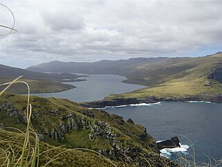
Carnley Harbour is a large natural harbour in the south of the Auckland Islands, a subantarctic part of the New Zealand Outlying Islands. Formed from the drowned crater of an extinct volcano, the harbour separates the mainland of Auckland Island from the smaller Adams Island. The harbour is sometimes referred to as the Adams Straits.

The Rosenthal Islands are a group of about islands fringing the west coast of Anvers Island, 11 km (6.8 mi) north of Cape Monaco, in the Palmer Archipelago of Antarctica.

Île aux Cochons, or Pig Island, is an uninhabited island in the subantarctic Crozet Archipelago. With an area of 67 km2 (26 sq mi) it is the third largest island of the group. Administratively, it is part of the French Southern and Antarctic Lands.

Île de la Possession, or Possession Island, formerly Île de la Prise de Possession, is part of the Subantarctic Crozet Archipelago. Administratively, it is part of the French Southern and Antarctic Lands. It is an important nesting site for seabirds.

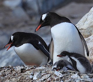
Île des Pingouins, or Penguin Island, is an uninhabited island in the subantarctic Crozet Archipelago of the southern Indian Ocean. With an area of only 3 km2 (1 sq mi) it is one of the smaller islands of the group. Administratively, it is part of the French Southern and Antarctic Lands. It is an important nesting site for seabirds.

Gibson's albatross, also known as the Auckland Islands wandering albatross or Gibson's wandering albatross, is a large seabird in the great albatross group of the albatross family. The common name and trinomial commemorate John Douglas Gibson, an Australian amateur ornithologist who studied albatrosses off the coast of New South Wales for thirty years.


