Administration in Karnali Province

Last updated
Karnali Province Nepal Karnali adm location map.svg
Karnali Province

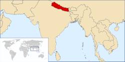
Karnali Province, formerly Karnali Province, is a province of Nepal. It is located in western part of Nepal, surrounded by Gandaki Province in the east, Lumbini Province in the south-east, Sudurpashchim Province in the west and Tibet of China in the north. [1]

Contents

Previously, Karnali Province was a development region of Nepal, which known as Mid-Western Development Region. The Mid-Western Development Region comprised three zones and 15 districts. Districts were divided into Municipalities and Villages.

Administrative structure

Karnali is divided into 10 districts and districts are subdivided into Municipalities.

Nepal
Karnali
Districts
Municipality Rural Municipality
Wards

Districts

Karnali is divided into 10 districts. [2]

Districts of Nepal
sr.DistrictsHeadquartersArea (km2.)Population (2011) [3] Official Website
1 Western Rukum District Musikot 1,213.49154,272
2 Salyan District Salyan 1,462242,444
3 Dolpa District Dunai 7,88936,700
4 Humla District Simikot 5,65550,858
5 Jumla District Chandannath 2,531108,921
6 Kalikot District Manma 1,741136,948
7 Mugu District Gamgadhi 3,53555,286
8 Surkhet District Birendranagar 2,451350,804
9 Dailekh District Narayan 1,502261,770
10 Jajarkot District Khalanga 2,230171,304

Municipality

There are 25 municipalities in Karnali Province, which is also known as Urban Municipality. [4]

RankNameNepaliDistrictPopulation (2011)AreaWebsite
1 Gurbhakot गुर्भाकोट Surkhet 43,765228.62
2 Dullu दुल्लु Dailekh 41,540156.77
3 Bheriganga भेरीगंगा Surkhet 41,407256.2
4 Bangad Kupinde बनगाड कुपिण्डे Salyan 36,052338.21
5 Chhedagad छेडागाड Jajarkot 35,295284.2
6 Bagchaur बागचौर Salyan 34,118163.14
7 Shaarda शारदा Salyan 33,730198.34
8 Aathabiskot अाठबिसकाेट Rukum West 33,601560.34
9 Bheri भेरी Jajarkot 33,515219.77
10 Musikot मुसिकोट Rukum West 32,939136.06
11 Panchapuri पञ्चपुरी Surkhet 32,231329.9
12 Lekbeshi लेकबेशी Surkhet 30,295180.92
13 Aathabis आठबीस Dailekh 29,227168
14 Chaurjahari चौरजहारी Rukum West 27,438107.38
15 Narayan नारायण Dailekh 27,037110.63
16 Chamunda Bindrasaini चामुण्डा विन्द्रासैनी Dailekh 26,14990.6
17 Nalgad नलगाड Jajarkot 25,597387.44
18 Khandachakra खाँडाचक्र Kalikot 20,288133.29
19 Chhayanath Rara छायाँनाथ रारा Mugu 20,078480.67
20 Chandannath चन्दननाथ Jumla 19,047102.03
21 Raskot रास्कोट Kalikot 16,27259.73
22 Tilagufa तिलागुफा Kalikot 15,766262.56
23 Tripurasundari त्रिपुरासुन्दरी Dolpa 10,104393.54
24 Birendranagar बीरेन्द्रनगर Surkhet 100,458245.06
25 Thuli Bheri ठूली भेरी Dolpa 8,370421.34

Rural Municipality

There are 54 rural municipality in Karnali Province: [4]

No.NameNepaliDistrictsPopulation (2011)Area (KM2)DensityOfficial Web
1 Gurans गुराँस Dailekh District 22,033164.79134
2 Bhairabi भैरवी Dailekh District 21,233110.46192
3 Naumule नौमुले Dailekh District 20,802228.5991
4 Mahabu महावु Dailekh District 19,277110.8174
5 Thantikandh ठाँटीकाँध Dailekh District 18,89688.22214
6 Bhagawatimai भगवतीमाई Dailekh District 18,778151.52124
7 Dungeshwar डुंगेश्वर Dailekh District 15,883105.19151
8 Mudkechula मुड्केचुला Dolpa District 5,129250.0821
9 Kaike काईके Dolpa District 3,576466.68
10 She Phoksundo शे फोक्सुन्डो Dolpa District 3,099123.0725
11 Jagadulla जगदुल्ला Dolpa District 2,27383.327
12 Dolpo Buddha डोल्पो बुद्ध Dolpa District 2,126377.386
13 Chharka Tongsong छार्का ताङसोङ Dolpa District 1,451345.574
14 Simkot सिमकोट Humla District 11,557785.8915
15 Sarkegad सर्केगाड Humla District 9,868306.732
16 Adanchuli अदानचुली Humla District 7,116150.6147
17 Kharpunath खार्पुनाथ Humla District 6,0118807
18 Tanjakot ताँजाकोट Humla District 5,964159.137
19 Chankheli चंखेली Humla District 5,5171,310.414
20 Namkha नाम्खा Humla District 3,9002,419.642
21 Junichande जुनीचाँदे Jajarkot District 21,733346.2163
22 Kushe कुसे Jajarkot District 20,621273.9775
23 Barekot बारेकोट Jajarkot District 18,083577.531
24 Shivalaya शिवालय Jajarkot District 15,269134.26114
25Tatopaniतातोपानी Jumla District 14,638525.5628
26Patarasiपातारासी Jumla District 14,571814.0718
27Tilaतिला Jumla District 13,607175.4978
28Kanaka Sundariकनकासुन्दरी Jumla District 12,977225.3958
29 Sinja सिंजा Jumla District 12,395153.2981
30Himaहिमा Jumla District 10,961132.3283
31Guthichaurगुठिचौर Jumla District 9,87042723
32 Narharinath नरहरिनाथ Kalikot District 21,366143.86149
33 Palata पलाता Kalikot District 15,303318.8448
34 Shubha Kalika शुभ कालिका Kalikot District 14,08097.32145
35 Sanni Triveni सान्नी त्रिवेणी Kalikot District 12,846136.7194
36 Pachaljharana पचालझरना Kalikot District 12,343166.9274
37 Mahawai महावै Kalikot District 8,323322.0726
38Khatyadखत्याड Mugu District 17,116281.1261
39Soruसोरु Mugu District 12,238365.833
40Mugum Karmarongमुगुम कार्मारोंग Mugu District 5,3962,106.913
41Sani Bheriसानीभेरी West Rukum District 22,194133.8166
42Triveniत्रिवेणी West Rukum District 19,40485.49227
43Banphikotबाँफिकोट West Rukum District 18,696190.4298
44Kumakhकुमाख Salyan District 24,972177.28141
45Kalimatiकालीमाटी Salyan District 23,005500.7246
46Chhatreshwariछत्रेश्वरी Salyan District 21,452150.69142
47Darmaदार्मा Salyan District 19,96681.46245
48Kapurkotकपुरकोट Salyan District 18,204119.21153
49Triveniत्रिवेणी Salyan District 16,634119.11140
50Siddha Kumakhसिद्ध कुमाख Salyan District 13,59389.36152
51Barahatalबराहताल Surkhet District 26,802455.0959
52Simtaसिम्ता Surkhet District 25,845241.6410
53Chaukuneचौकुने Surkhet District 25,240381.0166
54Chingadचिङ्गाड Surkhet District 17,275170.19102

Judiciary

High court

District court

Legislature

Constituency

Related Research Articles

Patarasi is a rural municipality located in Jumla District of Karnali Province of Nepal.

Naumule is a rural municipality located in Dailekh District of Karnali Province of Nepal.

Western Rukum District District in Karnali Province, Nepal

Western Rukum a part of Karnali Province, is one of the seventy-seven districts of Nepal. Musikot is the headquarter of the district.

Bangad Kupinde is an urban municipality located in Salyan district of Karnali Province of Nepal.

Chhedagad is an urban municipality located in the Jajarkot District of Karnali Province of Nepal.

Panchapuri is an urban municipality located in Surkhet District of Karnali Province of Nepal.

Lekbeshi is an urban municipality located in Surkhet District of Karnali Province of Nepal.

Aathabis is an urban municipality located in Dailekh District of Karnali Province of Nepal.

Chamunda Bindrasaini is an urban municipality located in Dailekh District of Karnali Province of Nepal.

Nalgad is an urban municipality located in Jajarkot District of Karnali Province of Nepal.

Khandachakra is an urban municipality located in Kalikot District of Karnali Province of Nepal.

Chhayanath Rara is an urban municipality located in Mugu District of Karnali Province of Nepal.

Thuli Bheri is an urban municipality located in Dolpa District of Karnali Province of Nepal. The district headquarter of Dolpa lies in Dunai, which is a village in the south-east of Thuli Beri.

Gurans is a rural municipality located in Dailekh District of Karnali Province of Nepal.

Bhairabi Rural Municipality is a rural municipality located in Dailekh District of Karnali Province of Nepal. The total area of the rural municipality is 110.46 square kilometres (42.65 sq mi) and the total population of the rural municipality as of 2011 Nepal census is 21,233 individuals. The rural municipality is divided into total 7 wards. A small portion of Dullu municipality with Bhairi Kalikathum, Kusapani, Rawalkot and Kasikandh Village development committees were incorporated to form this new rural municipality. The headquarters of the municipality is situated at Bhairi Kalikathum.

Sinja is a rural municipality located in Jumla District of Karnali Province of Nepal.

Mahabu is a rural municipality located in Dailekh District of Karnali Province of Nepal.

Bhagawatimai is a rural municipality located in Dailekh District of Karnali Province of Nepal.

Namkha Rural Municipality Rural municipality in Karnali Province, Nepal

Namkha is the largest rural municipality of Nepal located in Humla District of Karnali Province.

Mugum Karmarong is a rural municipality located in Mugu District of Karnali Province of Nepal. The rural municipality spans 2,106.91 square kilometres (813.48 sq mi) of area, with a total population of 5,393 according to a 2011 Nepal census. Mugum Karmarong is the second largest rural municipality of Nepal.

References

  1. "Home". karnali.gov.np.
  2. "Karṇālī (Province, Nepal) - Population Statistics, Charts, Map and Location".
  3. 2011 Census District Level Detail Report Archived 2018-09-02 at the Wayback Machine , Central Bureau of Statistics.
  4. 1 2 "स्थानीय तहहरुको विवरण" [Details of the local level bodies]. www.mofald.gov.np/en (in Nepali). Ministry of Federal Affairs and Local Development. Archived from the original on 31 August 2018. Retrieved 17 July 2018.