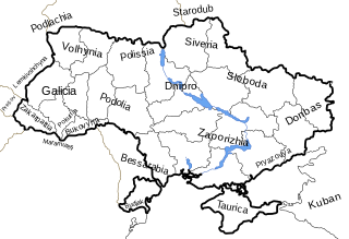
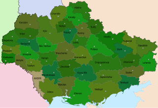
This is a list of historical regions in present-day Ukraine.
A governorate was a major and principal administrative subdivision of the Russian Empire. After the Bolshevik Revolution in 1917, governorates remained as subdivisions in the Byelorussian, Russian and Ukrainian Soviet republics, and in the Soviet Union from its formation in 1922 until 1929. The term is also translated as government or province. A governorate was headed by a governor, a word borrowed from Latin gubernator, in turn from Greek kyvernítis.

An oblast in Ukraine, sometimes translated as region or province, is the main type of first-level administrative division of the country. Ukraine's territory is divided into 24 oblasts, as well as one autonomous republic and two cities with special status. Ukraine is a unitary state, thus the oblasts do not have much legal scope of competence other than that which is established in the Ukrainian Constitution and devolved by law. Articles 140–146 of Chapter XI of the constitution deal directly with local authorities and their competence.
An uezd, or povit in a Ukrainian context was a type of administrative subdivision of the Grand Duchy of Moscow, the Tsardom of Russia, the Russian Empire, the Russian SFSR, and the early Soviet Union, which was in use from the 13th century. For most of Russian history, uezds were a second-level administrative division. By sense, but not by etymology, uezd approximately corresponds to the English "county".

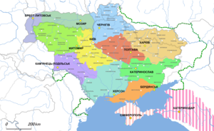
Kherson Governorate, known until 1803 as Nikolayev Governorate, was an administrative-territorial unit (guberniya) of the Russian Empire, with its capital in Kherson. It encompassed 71,936 square kilometres (27,775 sq mi) in area and had a population of 2,733,612 inhabitants. At the time of the census in 1897, it bordered Podolia Governorate to the northwest, Kiev Governorate to the north, Poltava Governorate to the northeast, Yekaterinoslav Governorate to the east, Taurida Governorate to the southeast, Black Sea to the south, and Bessarabia Governorate to the west. It roughly corresponds to what is now most of Mykolaiv, Kirovohrad and Odesa Oblasts in Ukraine and some parts of Kherson and Dnipropetrovsk Oblasts.
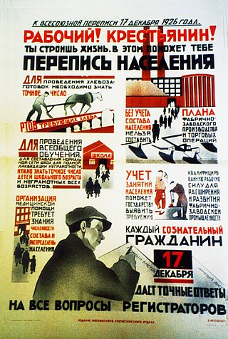
The 1926 Soviet census took place in December 1926. It was the first complete all-Union census in the Soviet Union and was an important tool in the state-building of the USSR, provided the government with important ethnographic information, and helped in the transformation from Imperial Russian society to Soviet society. The decisions made by ethnographers in determining the ethnicity (narodnost) of individuals, whether in the Asiatic or European parts of the former Russian Empire, through the drawing up of the "List of Ethnicities of the USSR", and how borders were drawn in mixed areas had a significant influence on Soviet policies. Ethnographers, statisticians, and linguists were drawing up questionnaires and list of ethnicities for the census. However, they also had the more ambitious goal of deliberately transforming their identities according to the principles of Marxism–Leninism. As Anastas Mikoyan put it, the Soviet Union was "creating and organising new nations".

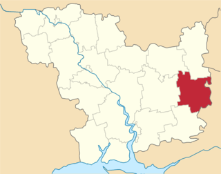
Mykolaiv Raion is a raion (district) in Mykolaiv Oblast, Ukraine with a pre-war population of 636,832. Its administrative center is the city of Mykolaiv.

Administrative divisions development in Ukraine reviews the history of changes in the administrative divisions of Ukraine, in chronological order.
During its existence from 1919 to 1991, the Ukrainian Soviet Socialist Republic consisted of many administrative divisions. Itself part of the highly centralized Soviet Union, sub-national divisions in the Ukrainian SSR were subordinate to higher executive authorities and derived their power from them. Throughout the Ukrainian SSR's history, other national subdivisions were established in the republic, including guberniyas and okrugs, before finally being reorganized into their present structure as oblasts. At the time of the Ukrainian SSR's independence from the Soviet Union, the country was composed of 25 oblasts (provinces) and two cities with special status, Kiev, the capital, and Sevastopol, respectively.
An okruha is a historical administrative division of the Ukrainian Soviet Socialist Republic that existed between 1923 and 1930. The system was intended as a transitional system between the Russian Imperial division of governorates and the modern equivalent of oblasts.

Tavria Okruha was an administrative subdivision of the Ukrainian State (Ukraine) created in April 1918. The okruha was governed by a starosta from Berdiansk. The territory consisted of the continental part of the earlier Tavria guberniia, without the territory of the Crimean Peninsula.
Odesa Governorate, was a territorial division of the Ukrainian SSR (Ukraine) that was created in January 1920 by a decision of the All-Ukrainian Revolutionary Committee. The new governorate was initially created from the western part of the Kherson Governorate.

Berezanka Raion was a subdivision of Mykolaiv OblastUkraine. Its administrative center was the urban-type settlement of Berezanka. The raion was abolished on 18 July 2020 as part of the administrative reform of Ukraine, which reduced the number of raions of Mykolaiv Oblast to four. The area of Berezanka Raion was merged into Mykolaiv Raion. The last estimate of the raion population was 22,422
Bereznehuvate Raion was a subdivision of Mykolaiv Oblast of Ukraine. Its administrative center was the urban-type settlement of Bereznehuvate. The raion was abolished on 18 July 2020 as part of the administrative reform of Ukraine, which reduced the number of raions of Mykolaiv Oblast to four. The area of Bereznehuvate Raion was merged into Bashtanka Raion. The last estimate of the raion population was 19,344

Bratske Raion was a subdivision of Mykolaiv Oblast of Ukraine. Its administrative center was the urban-type settlement of Bratske. The raion was abolished on 18 July 2020 as part of the administrative reform of Ukraine, which reduced the number of raions of Mykolaiv Oblast to four. The area of Bratske Raion was merged into Voznesensk Raion. The last estimate of the raion population was 17,129

Pervomaisk Raion is a raion (district) in Mykolaiv Oblast, Ukraine. Its administrative center is the town of Pervomaisk. Population: 145,213.

Novorossiya is a historical name, used during the era of the Russian Empire for an administrative area that would later become the southern mainland of Ukraine: the region immediately north of the Black Sea and Crimea. The province fell largely within a slightly wider area known in Ukrainian as the Stepovyna and in Russian as the Stepp "Steppe Land", or Nyz "Lower Land". The name Novorossiya, which means New Russia, entered official usage in 1764, after the Russian Empire conquered the Crimean Khanate, and annexed its territories, when Novorossiya Governorate was founded. Official usage of the name ceased after 1917, when the entire area was annexed by the Ukrainian People's Republic, precursor of the Ukrainian SSR.
Arbuzynka is a rural settlement in Pervomaisk Raion in the north of Mykolaiv Oblast, Ukraine. It hosts the administration of Arbuzynka settlement hromada, one of the hromadas of Ukraine. Population: 5,954.

Berezanka is a Rural settlement in Mykolaiv Raion in the south of Mykolaiv Oblast, Ukraine. It hosts the administration of Berezanka settlement hromada, one of the hromadas of Ukraine. Population: 4,000.
Yelanets is a rural settlement in Voznesensk Raion. Mykolaiv Oblast, Ukraine. It hosts the administration of Yelanets settlement hromada, one of the hromadas of Ukraine. Population: 4,636.