Quetta is a district in the northwestern part of the Balochistan province of Pakistan, on the border with Kandahar province, Afghanistan.
Sibi is a city situated in the Balochistan province of Pakistan. The city serves as the administrative headquarters of the district and tehsil of the same name.
Jaswal is a village and union council, an administrative subdivision, of Khushab
District]] in the Punjab Province of Pakistan. It is part of Khushab
.
Gandoi is a town and union council of Dera Bugti District in the Balochistan province of Pakistan. It has an altitude of 250 metres.
Appozai is town and union council of Zhob District in the Balochistan province of Pakistan. The capital of the district, Zhob, was originally known as Appozai.
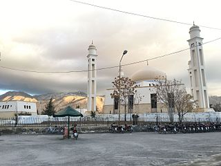
Bostan (بوستان) is a town, 30 km by road (18.64 mi) from Quetta city in the Balochistan province of Pakistan.It is located at 30°25'57N 67°00'22E and has an altitude of 1593 metres. Bostan is Tehsil of the Pishin District. It was previously included in Tehsil Karezat and covers an area between Mount Takathu and the Red Hills.
Spezand is a town and Union Council of Mastung District in the Balochistan province of Pakistan. It is located at 29°58'60N 67°0'0E and has an altitude of 1795 metres.
Cache Creek, originally Rivière de la Cache, is a tributary of the Bonaparte River in the Thompson Country of the Interior of British Columbia, Canada, joining that river at the town of Cache Creek, British Columbia, which is located at the junction of the Trans-Canada and Cariboo Highways.
Great Canyon is the official name of a stretch of the Homathko River as it pierces the heart of the Pacific Ranges of the Coast Mountains between the Chilcotin District of the British Columbia Interior and the Central Coast region at Bute Inlet. Also known unofficially as the Grand Canyon of the Homathko, it is located above the confluence of Mosley Creek. The canyon is the largest on the Homathko and lies on the west side of the Waddington Range massif containing Mount Waddington, the range's highest, and like other parts of the Homathko has been proposed as the site of dams in a region-wide hydroelectric development involving the Homathko, Southgate, Chilko and Taseko Rivers.
Muryali or Muriali is a town and union council in Dera Ismail Khan District of Khyber-Pakhtunkhwa, Pakistan. It is located at 31°49'0N 70°54'0E and has an altitude of 164 metres.
Choti Bala is a town and union council of Dera Ghazi Khan District in the Punjab province of Pakistan. It is located at 29°49'0N 70°15'0E and has an altitude of 217 metres.
Pindi Said Pur is a village and union council of Jhelum District in the Punjab Province of Pakistan. It is part of Pind Dadan Khan Tehsil. It is located at 32°40'0N 73°20'0E with an altitude of 215 metres (708 feet).
Behlolpur, is a town of Depalpur Tehsil in the Okara District of Punjab Province, Pakistan. The town is located at 30°42'0N 73°49'0E with an altitude of 174 metres (574 feet) and is part of the NA-145 constituency of the National Assembly.
Sikaryali is a town and union council of Gujrat District, in the Punjab province of Pakistan. It is part of Kharian Tehsil and is located at 32°37'0N 73°49'0E with an altitude of 223 metres.
Ahmedabad is a village and union council of Jhelum District in the Punjab Province of Pakistan. It is part of Pind Dadan Khan Tehsil, and is located at 32°40'0N 73°20'0E with an altitude of 215 metres (708 feet). Ahmedabad is on the bank of the Jhelum River, about 7 km from the M2 motorway Lilah Inter change and about 30 km from Pind Dadan Khan Tehsil and 36 km from Khewra Salt Mines. Ahmadabad is a Khokhar settlement in Jhelum District.
Charihan is a village and union council of Murree Tehsil in the Murree District of Punjab, Pakistan. It is located in the east of the tehsil at 33°49'0N 73°28'0E and is bounded to the north by Mussiari, to the north by Ghel, to the north-west by Murree city, to the west by Mussiari, to the south by Ban and to the south and east by Kotli Sattian.
Mehram is a town and union council of Kachi District in the Balochistan province of Pakistan. It is located at 28°51'0N 67°49'0E and has an altitude of 67 metres.

On 24 October 2016, three heavily armed terrorists carried out an attack on the Balochistan police training college in Quetta, Pakistan, killing 61 cadets and injuring more than 165 others. The Islamic State of Iraq and the Levant – Khorasan Province claimed responsibility for the attack, and Pakistan-based Lashkar-e-Jhangvi claimed to have collaborated with them. According to Pakistani authorities, the assailants came from Afghanistan and were in contact with their handlers there while perpetrating the attack.
Dilbar Mat is a town and union council of Dera Bugti District in the Balochistan province of Pakistan. It has an altitude of 250 metres.

