
Mystras or Mistras, also known in the Chronicle of the Morea as Myzethras or Myzithras (Μυζηθρᾶς), is a fortified town and a former municipality in Laconia, Peloponnese, Greece. Situated on Mt. Taygetus, above ancient Sparta, and below a Frankish castle, it served as the capital of the Byzantine Despotate of the Morea in the 14th and 15th centuries, experiencing a period of prosperity and cultural flowering during the Palaeologan Renaissance, including the teachings of Gemistos Plethon. The city also attracted artists and architects of the highest quality.

Elis or Ilia is a historic region in the western part of the Peloponnese peninsula of Greece. It is administered as a regional unit of the modern region of Western Greece. Its capital is Pyrgos. Until 2011 it was Elis Prefecture, covering the same territory.

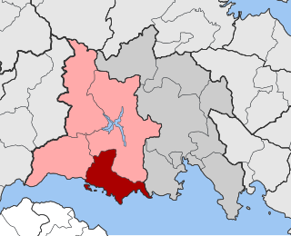
Andravida is a town and a former municipality in Elis, in the northwest of the Peloponnese peninsula of Greece. Since the 2011 local government reform it is part of the municipality Andravida-Kyllini, of which it is a municipal unit. The municipal unit has an area of 40.728 km2. Its population is about 3,700. The town was the capital of the Frankish Principality of Achaea in the late Middle Ages.
Pyrgos or Pyrgus may refer to:

Katakolo is a seaside town in the municipality of Pyrgos in western Elis, Greece. It is situated on a headland overlooking the Ionian Sea and separating the Gulf of Kyparissia from the rest of the Ionian. It is 11 km (6.8 mi) west of Pyrgos. The small village of Agios Andreas, which in ancient times was the natural harbour for Ancient Olympia, lies northwest of Katakolo.

Kalamata is the second most populous city of the Peloponnese peninsula, after Patras, in southern Greece and the largest city of the homonymous administrative region. As the capital and chief port of the Messenia regional unit, it lies along the Nedon River at the head of the Messenian Gulf.

Pyrgos is a city in the northwestern Peloponnese, Greece, capital of the regional unit of Elis and the seat of the Municipality of Pyrgos. The city is located in the middle of a plain, 4 kilometres from the Ionian Sea. The river Alfeios flows into sea about 7 km (4 mi) south of Pyrgos. The population of the town Pyrgos is 26,052, and of the municipality 45,365 (2021). Pyrgos is 16 km (10 mi) west of Olympia, 16 km (10 mi) southeast of Amaliada, 70 km (43 mi) southwest of Patras and 85 km (53 mi) west of Tripoli.

Larissos is a former municipality in Achaea, West Greece, Greece. Since the 2011 local government reform it is part of the municipality West Achaea, of which it is a municipal unit. The municipal unit has an area of 225.729 km2. Its seat of administration was in the village Lappas, part of the community Metochi. The municipal unit was named after the river Larissos, which flows through it. It is the westernmost municipal unit of Achaea, stretching along the Ionian Sea coast and the border with Elis to the southern part of the Movri hills. It is about 32 km southwest of Patras and 50 km north of Pyrgos.
Tolofon is a village and a former municipality in Phocis, Greece. Since the 2011 local government reform it is part of the municipality Dorida, of which it is a municipal unit. The municipal unit has an area of 131.384 km2. The seat of the municipality was in Erateini. The ancient site of Tolophon is located in the northeastern part of the municipal unit. It is situated on the mountainous north coast of the Gulf of Corinth.

Andreas Avgerinos (1820–1895) was a Greek politician from Elis.
Pheia or Phea (Φεά) was a city of ancient Elis in the Pisatis, situated upon the isthmus connecting the promontory Ichthys with the mainland. Pheia is mentioned by Homer, who places it near the Iardanus, which is apparently the mountain torrent north of Ichthys, and which flows into the sea on the northern side of the lofty mountain Skaphídi.

Chlemoutsi, also known as Clermont, is a medieval castle in the northwest of the Elis regional unit in the Peloponnese peninsula of southern Greece, in the Kastro-Kyllini municipality.

Glarentza, also known as or Clarenia, Clarence, or Chiarenza, was a medieval town located near the site of modern Kyllini in Elis, at the westernmost point of the Peloponnese peninsula in southern Greece. Founded in the mid-13th century by William II of Villehardouin, the town served as the main port and mint of the Frankish Principality of Achaea, being located next to the Principality's capital, Andravida. Commerce with Italy brought great prosperity, but the town began to decline in the early 15th century as the Principality itself declined. In 1428, Glarentza was ceded to the Byzantine Despotate of the Morea, and served as its co-capital, being the residence of one of the Palaiologos despots, until the Ottoman conquest in 1460. Under Ottoman rule, Glarentza declined rapidly as the commercial links with Italy were broken, and by the 16th century was abandoned and falling into ruin. Little remains of the town today: traces of the city wall, of a church and a few other buildings, as well as the silted-up harbour.

Kaiafas or the thermal springs of Kaiafas is a spa in the municipality of Zacharo in southwestern Greece. It is located 347 kilometres SW of Athens, 30 km SE of Pyrgos, 20 km (12 mi) S of Olympia, nearly 32 km N of Kyparissia and some 90 km NW of Kalamata.

The Barony of Karytaina or of Skorta was a medieval Frankish fiefdom of the Principality of Achaea, located in the Peloponnese peninsula in Greece, centred on the town of Karytaina in the mountainous region known as Skorta.
The Barony of Estamira or Stamira was a medieval Frankish fiefdom of the Principality of Achaea, located in the fertile plains of the Elis region of the Peloponnese peninsula in Greece, and centred on the now vanished fortress of Estamira.

Pontikokastro, known in French as Beauvoir and Italian as Belveder during the late Middle Ages, is a Byzantine castle in Agios Andreas, Katakolo, in the Peloponnese peninsula of Greece.
The Battle of Picotin was fought on 22 February 1316 between the Catalan forces of the infante Ferdinand of Majorca, claimant to the Principality of Achaea, and the forces loyal to Princess Matilda of Hainaut, comprising native levies from the barons loyal to the Princess as well as Burgundian knights. The battle ended in a crushing victory for Ferdinand, but he was later engaged and killed by the troops of Matilda's husband, Louis of Burgundy, at the Battle of Manolada.
The Metropolis of Elis and Olena is a Greek Orthodox episcopal see of the Church of Greece. During the period of Frankish rule it was a Roman Catholic see, and continues to the present day as a titular see in the Roman Catholic Church.

The Patras–Kyparissia railway is a railway line of the OSE in Achaea, Elis, and Messenia, southwestern Greece. This 163 km long single track metre-gauge line connects Patras, Pyrgos and Kyparissia.


