Agios Mamas, Limassol

Last updated
Agios Mamas

Άγιος Μάμας
View of Agios Mamas, Limassol 6.jpg
Agios Mamas village
Cyprus relief location map.jpg
Red pog.svg
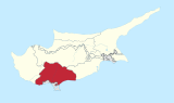
Agios Mamas
Location of Agios Mamas in Cyprus
Coordinates: 34°51′1″N32°56′53″E / 34.85028°N 32.94806°E / 34.85028; 32.94806 Coordinates: 34°51′1″N32°56′53″E / 34.85028°N 32.94806°E / 34.85028; 32.94806
CountryFlag of Cyprus.svg  Cyprus
District Limassol
Elevation
590 m (1,940 ft)
Population
(2001)
  Total105
[1]

Agios Mamas (Greek : Άγιος Μάμας) is a small village in the Limassol region of Cyprus. It is located on the southern slopes of the Troodos mountain range in the area famous for its Commandaria wine.

Greek language language spoken in Greece, Cyprus and Southern Albania

Greek is an independent branch of the Indo-European family of languages, native to Greece, Cyprus and other parts of the Eastern Mediterranean and the Black Sea. It has the longest documented history of any living Indo-European language, spanning more than 3000 years of written records. Its writing system has been the Greek alphabet for the major part of its history; other systems, such as Linear B and the Cypriot syllabary, were used previously. The alphabet arose from the Phoenician script and was in turn the basis of the Latin, Cyrillic, Armenian, Coptic, Gothic, and many other writing systems.

Village Small clustered human settlement smaller than a town

A village is a clustered human settlement or community, larger than a hamlet but smaller than a town, with a population ranging from a few hundred to a few thousand. Though villages are often located in rural areas, the term urban village is also applied to certain urban neighborhoods. Villages are normally permanent, with fixed dwellings; however, transient villages can occur. Further, the dwellings of a village are fairly close to one another, not scattered broadly over the landscape, as a dispersed settlement.

Limassol Place in Limassol District, Cyprus

Limassol is a city on the southern coast of Cyprus and capital of the eponymous district. Limassol is the second largest urban area in Cyprus after Nicosia, with an urban population of 183,658 and a metropolitan population of 239,842. Limassol has been ranked by TripAdvisor as the 3rd up-and-coming destination in the world, in its Top 10 Traveler’s Choice Destinations on the Rise. The city is also ranked 89th worldwide in Mercer's Quality of Living Survey (2017). In the ranking published by the Globalization and World Cities Research Network, Limassol has been classified global city in the 4th category.

Agios Mamas village church Ayios Mamas church Cyprus.JPG
Agios Mamas village church

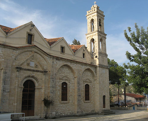
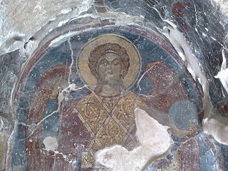
The village is built in an amphitheatric layout under Mount Zalaka. It is named after Saint Mamas, a 3rd-century Christian martyr and the main village church, built on the hill above the main settlement, is dedicated to the saint. A second small church on the southern outskirts of the village is dedicated to Saint Paraskevi and its interior is covered with wall paintings. The village also has a cultural centre with a small library next to the church and a shop with a post office and a bank in the centre of the village. [2]

Mammes of Caesarea semi-legendary child-martyr

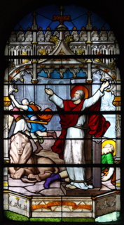
Saint Mammes of Caesarea is a child-martyr of the 3rd century. He was martyred at Caesarea. His parents, Theodotus and Rufina, were also martyred.

Martyr person who suffers persecution and death for advocating, refusing to renounce, and/or refusing to advocate a belief or cause, usually a religious one

A martyr is someone who suffers persecution and death for advocating, renouncing, refusing to renounce, or refusing to advocate a belief or cause as demanded by an external party. This refusal to comply with the presented demands results in the punishment or execution of the martyr by the oppressor. Originally applied only to those who suffered for their religious beliefs, the term has come to be used in connection with people killed for a political cause.

Mural piece of artwork painted or applied directly on a large permanent surface

A mural is any piece of artwork painted or applied directly on a wall, ceiling or other permanent surface. A distinguishing characteristic of mural painting is that the architectural elements of the given space are harmoniously incorporated into the picture.

Local inhabitants are mainly involved in viticulture as well as a growing olives, almonds and other fruit trees.

Viticulture science, production and study of grapes

Viticulture or winegrowing is the cultivation and harvesting of grapes. It is a branch of the science of horticulture. While the native territory of Vitis vinifera, the common grape vine, ranges from Western Europe to the Persian shores of the Caspian Sea, the vine has demonstrated high levels of adaptability to new environments. For this reason, viticulture can be found on every continent except Antarctica.

Olive species of plant

The olive, known by the botanical name Olea europaea, meaning "European olive", is a species of small tree in the family Oleaceae, found in the Mediterranean Basin from Portugal to the Levant, the Arabian Peninsula, and southern Asia as far east as China, as well as the Canary Islands and Réunion. The species is cultivated in many places and considered naturalized in all the countries of the Mediterranean coast, as well as in Argentina, Saudi Arabia, Java, Norfolk Island, California, and Bermuda. Olea europaea is the type species for the genus Olea.

Almond species of plant

The almond is a species of tree native to Mediterranean climate regions of the Middle East and Southern Asia. Almond is also the name of the edible and widely cultivated seed of this tree. Within the genus Prunus, it is classified with the peach in the subgenus Amygdalus, distinguished from the other subgenera by corrugations on the shell (endocarp) surrounding the seed.

Related Research Articles

Commandaria is an amber-coloured sweet dessert wine made in the Commandaria region of Cyprus on the foothills of the Troödos mountains. Commandaria is made from sun-dried grapes of the varieties Xynisteri and Mavro. While often a fortified wine, through its production method it often reaches high alcohol levels, around 15%, already before fortification. It represents an ancient wine style documented in Cyprus back to 800 BC and has the distinction of being the world's oldest named wine still in production, with the name Commandaria dating back to the crusades in the 12th century.

Ayios Dhometios Place in Nicosia District, Cyprus

Ayios Dhometios is a suburb located west of the Cypriot capital Nicosia. It has a population of 12,456 making it one of Cyprus' biggest municipalities. There is also a population of 2,314 within the area of Ayios Dhometios under Turkish control.

Galata, Cyprus Place in Nicosia District, Cyprus

Galata is a village in the Solea valley, located about 60 km west of the capital Nicosia, at an altitude of 620 m in the Troodos Mountains of Cyprus. It is a popular summer tourist destination for its cooler climate in the summer months. It is also well known on the island for its fruit produce. In Galata there is Panagia tis Podithou, church, which is a UNESCO World Heritage Site along with nine other Painted Churches in the Troödos Region.

Agios Athanasios, Thessaloniki Place in Greece

Agios Athanasios is a town and a former municipality in the Thessaloniki regional unit, Greece. Since the 2011 local government reform it is part of the municipality Chalkidona, of which it is a municipal unit. In 2011 the population was 14,753. The municipal unit Agios Athanasios has an area of 155.34 km2, and the community Agios Athanasios has an area of 35.527 km2.

Velanidia, Laconia Place in Greece

Velanidia is a Byzantine village in Laconia, Greece, within the municipality of Monemvasia. Also, it is situated at the southern edge of Peloponnese and more specifically at the southeast edge of mountain range Parnon. It includes several Byzantine churces, so it is offenly called as Small Agios Oros. This village is near at Cape Maleas.

Kakopetria Place in Nicosia District, Cyprus

Kakopetria is a town in Cyprus located 55 kilometres (34 mi) southwest of the capital, Nicosia, on the north facing foothills of the Troodos Mountains. It stands at an altitude of 667 metres and it is the highest village in the Solea Valley. The community has about 1,200 permanent inhabitants and a couple hundred more who either have a summer house or are originally from Kakopetria but work in Nicosia. Near Kakopetria there is church from 11th century, Agios Nikolaos tis Stegis, UNESCO World Heritage Site.

Kato Drys Place in Larnaca District, Cyprus

Kato Drys is a small village in Cyprus, northwest of Larnaca. It is near the villages of Pano Lefkara (4 km), Kato Lefkara (4 km), and Vavla (6 km).

Ypsonas municipality of Limassol District, Republic of Cyprus

Ypsonas is a municipality in Limassol prefecture of the Republic of Cyprus. It is one of the largest villages in the Limassol District of Cyprus and is located about 7 kilometers west of Limassol city. The southern part of the village is within the administrative borders of the British military base of Akrotiri - Episkopi. It has 10,916 residents as recorded in the Census of 2011.

Laneia Place in Limassol District, Cyprus

Laneia is a village at the foot of Mount Troodos on the main Limassol to Troodos road, about 26 km from Limassol in the country of Cyprus. Lania is one of the country's main wine producing villages.

Vouni in Limassol District, Cyprus

Vouni is a small village in Limassol District, Cyprus, located 7 km north of Agios Therapon. The name of the village is derived from its location, in which Vouni means "low mountain" in Greek.

Kapilio in Limassol, Cyprus

Kapilio is a small village in the Limassol region of Cyprus. It is located in the area famous for its Commandaria wine, built on a slight elevation in the valley of the Ambelikos river to the east of the Troodos mountain range.

Politiko in Nicosia District, Cyprus

Politiko is a village located in the Nicosia District of Cyprus. The hamlet of Filani is part of this municipality.

Agia Varvara, Nicosia in Nicosia District, Cyprus

Agia Varvara is a town located in the Nicosia District of Cyprus. Agia is the Greek word for "Saint" .The town is named after Saint Varvara or Saint Barbara. The village is located 22 km south from Nicosia and is at an altitude of 311 meters. The town is known for its many cultivated and barren pieces of land. The town hosts the Church of Agia Varvara, the Chapel of Agia Paraskevi, Chapel of Agios Nektarios and the Chapel of Holy Cross.

Esentepe, Kyrenia village in Kyrenia District, Cyprus

Agios Amvrosios is a village located in the Kyrenia District of Cyprus, east of the Kyrenia. It is under the de facto control Northern Cyprus.

Angastina village in Famagusta District, Cyprus

Angastina is a village in the Famagusta District of Cyprus, located around 20 km east of Nicosia, on the main road to Famagusta. It is under the de facto control of Northern Cyprus. Angastina is perched on a gentle river terrace chalk escarpment over the Pedias river plain at 66 metres above sea level.

Patriki village in Famagusta District, Cyprus

Patriki is a village in the Famagusta District of Cyprus, located on the Karpas Peninsula. It is under the de facto control of Northern Cyprus.

Mesana in Paphos District, Cyprus

Mesana is a village in the Paphos District of Cyprus, located 2 km northeast of Salamiou.

Choulou in Paphos District, Cyprus

Choulou is a village in the Paphos District of Cyprus, located 6 km west of Agios Fotios at an altitude of about 350m above sea level. It is located in the centre of the district next to the village Lemona and near Statos-Agios Photios and Letymbou villages.

Koili in Paphos District, Cyprus

Koili is a village in the Paphos District of Cyprus, located 2 kilometres (1.2 mi) northwest of Tsadha.

Limassol District District in Cyprus

Limassol District or Lemesos is one of the six districts of Cyprus. As of 2011, it had a population of 239.842, 77% of which was urban. Its main city is Limassol. Part of the British Overseas Territory of Akrotiri and Dhekelia forms an enclave on the Akrotiri Peninsula, under the sovereignty of the United Kingdom.

References

  1. Statistical Service of the Republic of Cyprus 2001 Population Census
  2. Cyprus Village link, local news site for the Commandaria region