
Chamonix-Mont-Blanc, more commonly known simply as Chamonix (Chamôni), is a commune in the Haute-Savoie department in the Auvergne-Rhône-Alpes region in Southeastern France. It was the site of the first Winter Olympics, held in 1924.

The Aiguille de Bionnassay is a mountain in the Mont Blanc massif of the Alps in France and Italy. It has been described as "one of the most attractive satellite peaks of Mont Blanc", and is located on its western side. The mountain's south and east ridges form the frontier between the two countries, and its summit is a knife-edge crest of snow and ice. Reaching it via any route provides a "splendid and serious snow and ice climb".

The Grand Combin is a mountain massif in the western Pennine Alps in the canton of Valais. At a height of 4,309 metres (14,137 ft) the summit of Combin de Grafeneire is one of the highest peaks in the Alps and the second most prominent of the Pennine Alps. The Grand Combin is also a large glaciated massif consisting of several summits, among which three are above 4000 metres. The highest part of the massif is wholly in Switzerland, although the border with Italy lies a few kilometres south.

The Aiguille Verte, which is French for "Green Needle", is a mountain in the Mont Blanc massif in the French Alps.
The Aiguilles Rouges are a crystalline mountainous massif of the French Prealps, opposite the Mont Blanc Massif. The colour of the iron rich gneiss (metamorphique) mountains gives the range its name. The highest summit is the Aiguille du Belvédère at 2,965 metres (9,728 ft). At the southern end of the range, Le Brévent at 2,525 metres (8,284 ft) is accessible by a cable car in the Planpraz and the Brévent sections.

The Aiguille d'Argentière is a mountain in the Mont Blanc massif on the border between France and Switzerland. The second highest summit of the Aiguille d'Argentière is the prominent rock-tower Flèche Rousse southeast of the main-summit.
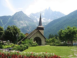
Les-Praz-de-Chamonix is a mountain village in the French Alps, part of the commune of Chamonix. Altitude: 1060 m (3477 ft.).

The Vanoise massif is a mountain range of the Graian Alps, located in the Western Alps. After the Mont Blanc Massif and the Écrins Massif it is the third-highest massif in France, reaching a height of 3,885 m at the summit of Grande Casse. It lies between Tarentaise Valley to the north and the Maurienne Valley in the south. The range is the site of France's first national park, established in 1963, Vanoise National Park. The ski resorts of Tignes and Val-d'Isère and the 2,770-metre-high Col de l'Iseran are located in the eastern part of the range.
The Pointe de Vouasson is a mountain of the Swiss Pennine Alps, overlooking Lac des Dix in the canton of Valais. It lies between the valleys of Hérémence (west) and Arolla (east), north of the Aiguilles Rouges d'Arolla.

La Cassorte is a mountain of the Swiss Pennine Alps, located west of Arolla in the canton of Valais. It lies on the range between the Lac des Dix and the Val d'Arolla, south of the Aiguilles Rouges d'Arolla.

The Aiguille du Tour is a mountain in the Mont Blanc massif, located on the border between Switzerland and France. The voie normale on the mountain is graded F (facile) and can be climbed from either the Albert Premier Hut on the French side or the Trient Hut on the Swiss side.

Pointe Kurz is a mountain of the Mont Blanc Massif, located on the border between France and Switzerland. It lies between the glaciers of Argentière and L'A Neuve, west of La Fouly, the closest locality.

The Aiguilles d’Arves is a mountain in the Arves massif in the French Alps. The mountain, comprising three separate peaks, is the highest point of the massif, and is located in the department of Savoie.

Aiguille Rouge is a mountain of Savoie, France. It lies in the Vanoise Massif and has an elevation of 3,227 metres above sea level. It is the highest point within the ski area of Les Arcs and is a fairly easy hike from the village below. It can also be accessed by a cable-car which almost reaches the summit area. In 2019 a footbridge was installed at the summit that offers a panoramic view of the valley.

The Aiguille du Chardonnet is a mountain in the Mont Blanc massif in Haute-Savoie, France. It lies between the Glacier du Tour and the Argentière Glacier. The border with Switzerland runs just east of the summit. The East or Forbes Arete provides a popular and classic mountaineering route to the summit.
The Aiguille Noire de Peuterey is a mountain of the Mont Blanc massif in Italy, forming part of the Peuterey ridge to the summit of Mont Blanc with its higher neighbour, the Aiguille Blanche de Peuterey.

A double summit, double peak, twin summit, or twin peak is a mountain or hill that has two summits, separated by a col or saddle.

L'Aguille Rouge is a 2,545 metres high mountain of the Cottian Alps, located on the Main chain of the Alps NW of the Col de l'Échelle.

