
Saint Georges is an unincorporated town and former municipality situated on the Chesapeake and Delaware Canal in New Castle County, Delaware, United States, approximately midway between the Delaware River and Chesapeake Bay.
Burlington is a census-designated place (CDP) in Mineral County, West Virginia, United States, along U.S. Route 50 crossing Pattersons Creek. As of the 2020 census, its population was 131. It is part of the Cumberland, MD-WV Metropolitan Statistical Area.
Pencader Hundred is an unincorporated subdivision of New Castle County, Delaware. Hundreds were once used as a basis for representation in the Delaware General Assembly, and while their names still appear on all real estate transactions, they presently have no meaningful use or purpose except as a geographical point of reference. It is named after Pencader, Carmarthenshire, Wales.

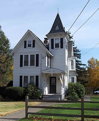
Dr. Joshua Clayton was an American physician and politician from Mount Pleasant in Pencader Hundred, New Castle County, Delaware. He was an officer of the Continental Army in the American Revolution, and a member of the Federalist Party, who served in the Delaware General Assembly, as Governor of Delaware and as U.S. Senator from Delaware.
Hume is a small unincorporated village in Fauquier County, Virginia. Hume is five miles south of Interstate 66's Exit 18 and is named for the local Hume family. It runs along Virginia State Route 688. It is east of the Rappahannock County line. The community has a post office and ZIP Code of 22639, and is home to a local winery.

Augusta Downtown Historic District is a historic district that encompasses most of Downtown Augusta, Georgia and its pre-Civil War area.

The North Egremont Historic District is a historic district in Egremont, Massachusetts. It encompasses a crossroads village in the northern part of the town, where the north-south road, now Massachusetts Route 71, connects Kinderhook, New York to points further south, and the east-west road runs from Hillsdale, New York, toward Housatonic, Massachusetts. The district encompasses some 236 acres (96 ha) along these and other roadways near their junction. It was listed on the National Register of Historic Places in 1989.
Marion is a neighborhood in the town of Southington, Connecticut, United States. It is generally the area in the vicinity of the intersection of Route 322 and Marion Avenue, just north of the Cheshire town line.

The Amwell Valley is a small valley in Hunterdon County, New Jersey, between the Hunterdon Plateau and the Sourlands. It comprises Stockton, parts of Delaware Township, West Amwell, East Amwell, Flemington and Raritan Township. The region borders the Delaware River to the west and the South Branch Raritan River to the east. The entire area has elevations around 200 feet above sea level. US 202 is the main route running west to east through the valley. Old York Road also passes through the valley, taking a generally more southern route through Raritan and along the Sourlands at Mount Airy. Like the Hunterdon Plateau, Amwell Valley still has a large number of farms due to its sufficient climate, relatively flat land and the presence of silt-loams soils. The valley is home to Unionville Winery and Old York Cellars in Ringoes.

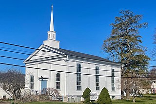
Lewes Presbyterian Church is a historic Presbyterian church building located at 100 Kings Highway in Lewes, Sussex County, Delaware. It was built in 1832, as a frame meeting house measuring 45 feet by 37 feet. In 1869, the church was renovated to add a number of a Gothic Revival style features and the addition of a chancel with Gothic windows. In 1886–1887, the tower and belfry were added and two massive Corinthian order columns were added to the interior. In 1931, the church acquired its Colonial Revival style front door.

The Old Rose Tree Tavern is an historic, American inn and tavern that is located in Rose Tree Park, just north of the borough of Media, in Upper Providence Township, Delaware County, Pennsylvania.
The Courthouse Square and Mechanics' Row Historic District is a historic district in Maysville, Kentucky, USA. The district structures are situated on Third Street between Market and Sutton Streets.

Fanshawe Pioneer Village is an open-air museum established in 1959 and located in the Fanshawe Conservation Area in London, Ontario. The village uses historical re-enactments to communicate the history of rural communities in the former townships of Westminster, London, North Dorchester, Delaware, West Nissouri and Lobo in Middlesex County from 1820 to 1920 and the founding and development of the City of London up to 1840.
Iron Hill is a prominent geographical feature in the vicinity of Newark, Delaware, in the United States. With a topographic prominence of 200 feet (61 m), it is the most prominent hill in Delaware. However, its peak elevation of 328 feet (100 m) means that it is not the state's highest point, which is located in the Piedmont plateau region near Centreville where a peak elevation of 448 feet (137 m) is attained at Ebright Azimuth. The hill is named for its iron deposits, which were mined over a 200-year period during the 18th and 19th centuries. It is part of a New Castle County park known as Iron Hill Park.

Little York is an unincorporated community located along the border of Alexandria and Holland townships in Hunterdon County, in the U.S. state of New Jersey. Little York is located on County Route 614 3.1 miles (5.0 km) north-northeast of Milford. Little York has a post office with ZIP Code 08834.
Mount Pleasant is an unincorporated community located along County Route 519 on the border of Alexandria Township and Holland Township, in Hunterdon County, New Jersey. The Mount Pleasant Historic District was listed on the National Register of Historic Places in 1987.

The Aiken Stand Complex is a historic pair of buildings at the junction of Royalton Turnpike and Sayer Road in rural Barnard, Vermont. Built c. 1805 and 1835, they were the centerpiece of a small village that flourished in the first half of the 19th century, when the Turnpike was the principal north–south route through the region. The buildings were listed on the National Register of Historic Places in 1983.
The Charlotte Center Historic District encompasses the historic 19th-century town center of Charlotte, Vermont. Settled c. 1790 and developed mainly in the mid-19th century, the village, stretched along Church Hill Road west of Hinesburg Road, retains a well-preserved 19th-century atmosphere of residential, civic, and commercial buildings. The district was listed on the National Register of Historic Places in 1984.

The Asbury Historic District is a 288-acre (117 ha) historic district encompassing the community of Asbury in Franklin Township of Warren County, New Jersey. It is bounded by County Route 632, County Route 643, Maple Avenue, Kitchen Road, and School Street and extends along the Musconetcong River into Bethlehem Township of Hunterdon County. It was listed on the National Register of Historic Places on March 19, 1993 for its significance in architecture, industry, religion, community development, politics/government, and commerce. The district includes 141 contributing buildings, a contributing structure, two contributing sites, and four contributing objects.

Bevans, also known as Peters Valley, is an unincorporated community located at the intersection of Bevans Road, Walpack Road, and Kuhn Road in Sandyston Township of Sussex County, New Jersey. The village is now part of the Delaware Water Gap National Recreation Area. Both the Delaware River and the Old Mine Road are nearby.


