
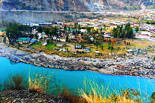
Awantipora or Avantipur or Aavantipur, known as Woontpor in Kashmiri, is a town, just opposite of Pulwama city, on the banks of the river Jhelum in the Pulwama district of Jammu and Kashmir, India. It is on the Jammu-Srinagar National Highway, south of Srinagar and north of Anantnag. Awantipora was named after the Kashmiri king Avantivarman and has the ruins of two 9th century Hindu temples built by him.

Kulgam, known as Kolgom in Kashmiri, is a town, an administrative division and capital of the Kulgam district in the Indian union territory of Jammu and Kashmir. It is located at a distance of 67 km (42 mi) from the summer state capital of Jammu and Kashmir, Srinagar. The city is divided into 16 electoral wards that has a population of 23,584, of which 12,605 are males while 10,979 are females.

Qazigund, also known as Gateway Of Kashmir, is a town and in the union territory of Jammu and Kashmir, India. Qazigund is located at 33.59°N 75.16°E. It has an average elevation of 1670 m (5478 feet) above mean sea level.

Shopian or Shupiyan, known as Shupyan in Kashmiri, is an administrative division of the Shopian district, located in southern part of Kashmir Valley, of Jammu and Kashmir, India. Shopian is called the ''Apple town of Kashmir'' as majority of the population engages in apple growing practices which also provides employment to more than 60% of the population. It is 2nd richest district in Kashmir region after Srinagar.
Ramban is a town in Ramban district of Jammu and Kashmir, India, which is the district headquarters of Ramban district. It lies on the banks of the Chenab river in Chenab Valley on the National Highway-1A at about 120 km from Jammu and about 130 km from Srinagar, making it almost the central point on the Jammu-Srinagar National Highway.
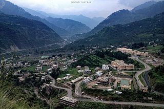
Ramban district is an administrative district in the Jammu division of Indian-administered Jammu and Kashmir in the disputed Kashmir region. It is located in a valley surrounded the Pir Panjal range. It was carved out as a separate district from erstwhile Doda district in 2007. It is located in the Jammu division. The district headquarters are at Ramban town, which is located midway between Jammu and Srinagar along the Chenab river in the Chenab valley on National Highway-44, approximately 151 km from Jammu and Srinagar.
Kulgam district is an administrative district of Indian-administered Jammu and Kashmir in the disputed Kashmir region. It is in the Kashmir division and is located at a distance of 18 kilometres (11 mi) towards south-west of Anantnag. The district comprises block, tehsil and town of Kulgam.
Qaimoh is a block, a town and a notified area committee in Kulgam District in the union territory of Jammu and Kashmir, India. It is four miles to the west of Anantnag and six miles to the north of Kulgam District. It is 55 km to the south of Srinagar city. Qaimoh is one of the largest blocks in Jammu and Kashmir..
Kilam or (Kelam) is a village in Devsar Tehsil in the Kulgam district of Jammu and Kashmir. It is located 7 km (4.3 mi) north of the district headquarters, Kulgam and is 54 km (34 mi) from Srinagar, the summer capital of union territory of Jammu and Kashmir.
Wakura is a village located in the Ganderbal district of Jammu and Kashmir, India. In 2013 it was given tehsil status, with the tehsil headquarters located in Lar, 13 km away.
Aripanthan is a village and panchayat halqa in Beerwah tehsil of Budgam district in the Indian union territory of Jammu and Kashmir. It is situated at the centre of tehsil Beerwah and tehsil Magam. It is located about 27 km (17 mi) west from summer capital of Jammu and Kashmir, Srinagar and about 28 km (17 mi) north from district headquarters in Budgam.
Keller is a village located in Shopian district of the Indian union territory of Jammu and Kashmir. District headquarters are located in Shopian.
Yaripora or Yaripur is the second largest town by area and fourth least populous area of Kulgam district located in the union territory of Jammu and Kashmir in India. Its headquarters are located in Kulgam which is 12.8 km (8.0 mi) away from the main town of Yaripora. Most of its area is situated on the banks of rivulet Sonamann, a tributary of Veshaw that in turn joins the Jehlum at Sangam which comes under the Pir Panjal Range. Yaripora town has two electoral wards, with a population of 12,123, of which 6,043 are males and 6,080 are females, reported by the 2011 Census of India.
Khadermoh is a village located in Pulwama district in Indian union territory of Jammu and Kashmir. At a distance of 14.6 km, its district headquarters and administrative units are located in Pulwama via Pampore - Kakapora Road and Pulwama-Srinagar Road that connects Khadermoh village to state capital Srinagar which is situated 19.5 km away via NH44 and NH1.
Diver Anderbugh is a village situated in the Lolab Valley, Kupwara, Jammu and Kashmir, India. The village is combination of two places i,e Diver and Anderbugh. Common name of village is Diver. The site is connected to the village of Anderbugh. It is situated 25 kilometres (16 mi) away from district headquarter Kupwara.
Frisal is a Tehsil and CD Block in district of Kulgam, Jammu and Kashmir, India. It is 14kms far from District Headquarter Kulgam and 6 Kms away from NH44 Bijbehara, situated on Bijbehara, Arwani-Frisal-Kulgam road. Its boundaries connect three districts of South kashmir. Frisal is 2nd largest town as per population in district Kulgam. The main source of income of this tehsil is agriculture, Horticulture, Business and Govt Jobs. There are many springs in town Frisal and is known as town of springs in district Kulgam. Frisal town is economically average and educationally well. Presently there are so many offices like Tehsil office, Block office,JK Bank, Punjab National Bank,social welfare office, Model Hospital(not functional yet) Govt. Degree college,one Higher secondary, 5 high Schools and several lower educational institutions.

Ichgam, also known as Ichigam, is a census town located in the Indian administered union territory of Jammu and Kashmir's Budgam district. It falls under the administrative division of tehsil Budgam, one of the nine tehsils of district Budgam. It is one of the most populated area of Budgam district. It is roughly 5 km (3.1 mi) away from district Budgam and nearly 19 km (12 mi) away from Srinagar, the summer capital of union territory of Jammu and Kashmir. Ichgam village consists of four blocks — Ichgam-A, Ichgam-B, Ichgam-C and Ichgam-D. The village consists of both major sects of Islam, Shias (85-90%) and Sunnis(10-15%). There is also a Hindu minority.
Lolipora, also known as Lolipur, is a village and a Panchayat Halqa in Pattan tehsil of Baramulla district in the Indian union territory of Jammu and Kashmir. It is located 23 km (14 mi) towards east of district headquarters, Baramulla and 32 km (20 mi) from the summer capital of Jammu and Kashmir, Srinagar. Sopore, Baramulla, Bandipora and Srinagar are the nearby cities to Lolipora.
Yamrach is a village in Qaimoh block in Kulgam district of Jammu and Kashmir.It is located at 13 km from Kulgam.

Zeipora is a village located in Devsar tehsil of Kulgam district in Jammu and Kashmir, India. It is situated 6 kilometres (3.7 mi) away from sub-district headquarter Devsar and 8 kilometres (5.0 mi) away from district headquarter Kulgam.

