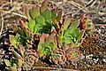
Ukraine is the second-largest European country, after Russia. Its various regions have diverse geographic features ranging from highlands to lowlands, as well as climatic range and a wide variety in hydrography. Most of the country lies within the East European Plain.
Ukraine used to attract more than 20 million foreign citizens every year. But since 2014 this has lowered to about 10 million. Visitors primarily come from Eastern Europe, but also from Western Europe, as well as Turkey and Israel.

This is a list of historical regions in present-day Ukraine.

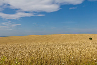
Dnipropetrovsk Oblast, is an oblast (province) in simultaneously southern, eastern and central Ukraine, the most important industrial region of the country. It was created on February 27, 1932. Dnipropetrovsk Oblast has a population of about 3,096,485, approximately 80% of whom live centering on administrative centers: Dnipro, Kryvyi Rih, Kamianske, Nikopol and Pavlohrad. The Dnieper River runs through the oblast.

Kirovohrad Oblast, also known as Kirovohradshchyna, is an oblast (region) in central Ukraine. The administrative center of the oblast is the city of Kropyvnytskyi. Its population is 903,712. It is Ukraine's second least populated oblast, behind Chernivtsi.

Mykolaiv Oblast, also referred to as Mykolaivshchyna, is an oblast (province) of Ukraine. The administrative center of the oblast is the city of Mykolaiv. At the most recent estimate, the population of the oblast stood at 1,091,821.

The Southern Bug, also called Southern Buh, and sometimes Boh River, is a navigable river located in Ukraine. It is the second-longest river in Ukraine.

Voznesensk is a city in Mykolaiv Oblast, Ukraine. It serves as the administrative center of Voznesensk Raion within the oblast. It hosts the administration of the Voznesensk urban hromada. The city has a population of 33,442.

Zavodske is a city in Myrhorod Raion, Poltava Oblast, Ukraine. It hosts the administration of Zavodske urban hromada, one of the hromadas of Ukraine. Population: 7,712.

The Seven Wonders of Ukraine are seven historical and cultural monuments of Ukraine, which were chosen in the Seven Wonders of Ukraine contest held in July, 2007. This was the first public contest of that kind which was followed by the Seven Natural Wonders of Ukraine, the Seven Wonderful Routes of Ukraine, and the Seven Wonderful Castles of Ukraine. All nominated sites are publicly owned protected areas of at least regional level, available for tourism.

Granite-steppe lands of Buh is a regional landscape park in the north-west of Mykolaiv Oblast in Ukraine.
Inhul River Park is a regional landscape park in Mykolaiv region of Ukraine.
Drabiv is a rural settlement in Zolotonosha Raion, Cherkasy Oblast, central Ukraine. It hosts the administration of Drabiv settlement hromada, one of the hromadas of Ukraine. Population: 6,085.

The Regional designations of Montana vary widely within the U.S state of Montana. The state is a large geographical area that is split by the Continental Divide, resulting in watersheds draining into the Pacific Ocean, Gulf of Mexico and Hudson's Bay. The state is approximately 545 miles (877 km) east to west along the Canada–United States border and 320 miles (510 km) north to south. The fourth largest state in land area, it has been divided up in official and unofficial ways into a variety of regions. Additionally, Montana is part of a number of larger federal government administrative regions.

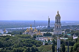
The Holosiiv National Nature Park is a protected remnant of forest surrounded by the urban area of the city of Kyiv, Ukraine. It is located on the Kyiv hills, in the Dniester-Dnieper forest-steppe province, North-Dnieper lowland and steppe zone of Left-Bank Dnieper province, in Holosiivskyi District. Its total area is 4525.52 hectares, of which 1879.43 hectares are in permanent use. It is managed by the Ministry of Ecology and Natural Resources of Ukraine.

Kiliia Raion was a raion (district) in Odesa Oblast of Ukraine. It was part of the historical region of Bessarabia. Its administrative center was the city of Kiliia. The small sector of the Danube Delta that lies in Ukraine lied partially in this raion. The raion was abolished and its territory was merged into Izmail Raion on 18 July 2020 as part of the administrative reform of Ukraine, which reduced the number of raions of Odesa Oblast to seven. The last estimate of the raion population was 50,386.

The Idaho Batholith ecoregion is a Level III ecoregion designated by the United States Environmental Protection Agency (EPA) in the U.S. states of Idaho and Montana. It is contained within the following biomes designated by the World Wild Fund for Nature (WWF): temperate coniferous forests; temperate grasslands, savannas, and shrublands; and deserts and xeric shrublands.
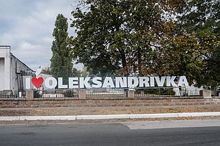
Oleksandrivka is a rural settlement in Voznesensk Raion, Mykolaiv Oblast, Ukraine. It hosts the administration of Oleksandrivka settlement hromada, one of the hromadas of Ukraine. Population: 5,040.

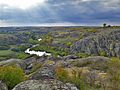
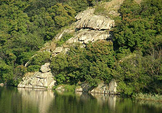
Bug Gard National Nature Park covers an area along the Southern Bug River in south-central Ukraine. At this point, the Southern Bug River cuts through the southern edge of the Ukrainian Shield. The park is therefore a canyon that transitions the river from the upland plateau to the steppe region. The word 'gard' in the name refers to a type of fishing structure used in the Cossack era. The park is spread in sections over Voznesensk and Pervomaisk districts of Mykolaiv Oblast. The major portions are about 140 km upstream from the estuary of the Southern Bug at the Black Sea.