Alastair Macdonald

Last updated
Alastair Macdonald MBE
Born1932
Nationality British
Known forDeputy Director of the Directorate of Overseas Surveys c1971-1982
Director of Surveys and Production at Ordnance Survey 1982-1992

Alastair Macdonald MBE is a retired land surveyor and author. [1]

Order of the British Empire British order of chivalry

The Most Excellent Order of the British Empire is a British order of chivalry, rewarding contributions to the arts and sciences, work with charitable and welfare organisations, and public service outside the civil service. It was established on 4 June 1917 by King George V and comprises five classes across both civil and military divisions, the most senior two of which make the recipient either a knight if male or dame if female. There is also the related British Empire Medal, whose recipients are affiliated with, but not members of, the order.

Surveying The technique, profession, and science of determining the positions of points and the distances and angles between them

Surveying or land surveying is the technique, profession, art and science of determining the terrestrial or three-dimensional positions of points and the distances and angles between them. A land surveying professional is called a land surveyor. These points are usually on the surface of the Earth, and they are often used to establish maps and boundaries for ownership, locations, such as building corners or the surface location of subsurface features, or other purposes required by government or civil law, such as property sales.

An author is the creator or originator of any written work such as a book or play, and is also considered a writer. More broadly defined, an author is "the person who originated or gave existence to anything" and whose authorship determines responsibility for what was created.

Contents

Achievements

Macdonald decided to become a surveyor at the age of nine. [1]

He took part in two Spitsbergen expeditions while at Cambridge University. [1]

Spitsbergen Largest island of the Svalbard archipelago in northern Norway

Spitsbergen is the largest and only permanently populated island of the Svalbard archipelago in northern Norway. Constituting the westernmost bulk of the archipelago, it borders the Arctic Ocean, the Norwegian Sea, and the Greenland Sea. Spitsbergen covers an area of 37,673 km2 (14,546 sq mi), making it the largest island in Norway and the 36th-largest in the world. The administrative centre is Longyearbyen. Other settlements, in addition to research outposts, are the Russian mining community of Barentsburg, the research community of Ny-Ålesund, and the mining outpost of Sveagruva. Spitsbergen was covered in 21,977 km2 (8,485 sq mi) of ice in 1999, which was approximately 58.5% of the island's total area.

He joined the Directorate of Colonial Surveys in 1955, [1] serving in field parties in Kenya, Southern Cameroons, Uganda, the Bahamas, Sarawak, Nyasaland, Bechuanaland and Zambia. [1] In 1969 he was seconded to the government of Malawi. [1]

Kenya republic in East Africa

Kenya, officially the Republic of Kenya, is a country in Africa with 47 semiautonomous counties governed by elected governors. At 580,367 square kilometres (224,081 sq mi), Kenya is the world's 48th largest country by total area. With a population of more than 52.2 million people, Kenya is the 27th most populous country. Kenya's capital and largest city is Nairobi while its oldest city and first capital is the coastal city of Mombasa. Kisumu City is the third largest city and also an inland port on Lake Victoria. Other important urban centres include Nakuru and Eldoret.

Southern Cameroons Former British mandate territory

Southern Cameroons was the southern part of the British Mandate territory of British Cameroons in West Africa. Since 1961 it has been part of the Republic of Cameroon, where it makes up the Northwest Region and Southwest Region. Since 1994, pressure groups in the territory have sought independence from the Republic of Cameroon, and the Republic of Ambazonia was declared by the Southern Cameroons Peoples Organisation (SCAPO) on 31 August 2006.

Uganda Republic in East Africa

Uganda, officially the Republic of Uganda, is a country in East-Central Africa. It is bordered to the east by Kenya, to the north by South Sudan, to the west by the Democratic Republic of the Congo, to the south-west by Rwanda, and to the south by Tanzania. The southern part of the country includes a substantial portion of Lake Victoria, shared with Kenya and Tanzania. Uganda is in the African Great Lakes region. Uganda also lies within the Nile basin, and has a varied but generally a modified equatorial climate.

From 1971 he served with the Ministry of Defence before becoming Deputy Director of the Directorate of Overseas Surveys. [1]

Ministry of Defence (United Kingdom) United Kingdom government department responsible for implementing the defence policy

The Ministry of Defence is the British government department responsible for implementing the defence policy set by Her Majesty's Government and is the headquarters of the British Armed Forces.

In 1982 he moved to the Ordnance Survey where he was Director of Surveys and Production until his retirement in 1992. [1] [2]

Ordnance Survey National mapping agency of the UK for Great Britain

Ordnance Survey (OS) is the national mapping agency for Great Britain. The agency's name indicates its original military purpose, which was to map Scotland in the wake of the Jacobite rising of 1745. There was also a more general and nationwide need in light of the potential threat of invasion during the Napoleonic Wars. Since 1 April 2015 Ordnance Survey has operated as Ordnance Survey Ltd, a government-owned company, 100% in public ownership. The Ordnance Survey Board remains accountable to the Secretary of State for Business, Energy and Industrial Strategy. It is also a member of the Public Data Group.

In 2002 he spoke at the International Court of Justice in a case concerning the maritime boundary between Cameroon and Nigeria. [3]

In 2009 he was awarded an MBE for services to the resolution of boundary disputes in Africa and to cartography more generally. [4]

Publications

Related Research Articles

Foreign relations of Cameroon

Cameroon's noncontentious, low-profile approach to foreign relations puts it squarely in the middle of other African and developing country states on major issues. It supports the principles of non-interference in the affairs of third world countries and increased assistance to underdeveloped countries. Cameroon is an active participant in the United Nations, where its voting record demonstrates its commitment to causes that include international peacekeeping, the rule of law, environmental protection, and Third World economic development. In the UN and other human rights fora, Cameroon's non-confrontational approach has generally led it to avoid criticizing other countries.

Controller of the Navy (Royal Navy)

The post of Controller of the Navy was originally created in 1859 when the Surveyor of the Navy's title changed to Controller of the Navy. In 1869 the controllers office was abolished and his duties were assumed by that of the Third Naval Lord who's title then changed to Third Naval Lord and Controller of the Navy. In 1904 his title was changed again to Third Sea Lord and Controller of the Navy. In 1965 the office of the Third Sea Lord was abolished. The post holder is responsible for procurement and matériel in the British Royal Navy.

A cadastre is a comprehensive land recording of the real estate or real property's metes-and-bounds of a country.

Gerald Smedley Andrews, was a Canadian frontier teacher, farm and ranch hand, cook, horse wrangler, engineer and soldier.

Colonel Sir Charles Frederick Arden-Close, was a British geographer and surveyor. He was Director General of the Ordnance Survey from 1911 to 1922. His insistence on attention to detail saw the improvement of many attitudes and methods at the Ordnance Survey. Close's planning saw the production of many maps now viewed as pinnacles in the classic period of map making. He was born Charles Frederick Close and changed his surname to Arden-Close in 1938 so as to comply with a bequest.

County surveyor

A county surveyor is a public official in the United States and the United Kingdom.

Down Survey

The Down Survey was a cadastral survey of Ireland, carried out by English scientist, William Petty, in 1655 and 1656.

Charles Morris (surveyor general) Chief Justice of the Nova Scotia Supreme Court and surveyor general

Charles Morris army officer, served on the Nova Scotia Council, Chief Justice of the Nova Scotia Supreme Court (1776–1778) and, the surveyor general for over 32 years, he created some of the first British maps of Canada's maritime region and designed the layout of Halifax, Lunenburg, Lawrencetown, and Liverpool. In Halifax he laid out both the present-day down town core and the Halifax Common.

Maritime Delimitation in the Black Sea case

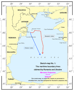
The Case concerning maritime delimitation in the Black Sea [2009] ICJ 3 was a decision of the International Court of Justice (ICJ). On September 16, 2004, Romania brought its case to the court after unsuccessful bilateral negotiations. On February 3, 2009, the court handed down its verdict, establishing a maritime boundary including the continental shelf and exclusive economic zones for Romania and Ukraine.

The Ordnance Survey International and its predecessors built an archive of air photography, map and survey records for the United Kingdom from 1946 to 1999. The Ordnance Survey International Collection held mapping records that were acquired outside the UK.

Martin Hotine British Army officer

Brigadier Martin Hotine CMG CBE was the head of the Trigonometrical and Levelling Division of the Ordnance Survey responsible for the 26-year-long retriangulation of Great Britain (1936–1962) and was the first Director General of the Directorate of Overseas Surveys (1946–1985).

The Equatorial Guinea – Nigeria Maritime Boundary Treaty is a 2000 treaty between Equatorial Guinea and Nigeria which delimits a portion of the maritime boundary between the two countries.

The Atlantika Mountains are an extension of the Cameroon line of volcanic mountains, spanning the border between Nigeria and Cameroon. They lie to the southeast of Yola, the capital of Adamawa State in Nigeria, and southwest of the Mandara mountains. In Cameroon, they are part of the North Region. They are north of the Adamawa Plateau and west of the Faro National Park in Cameroon. The massif rises to about 1,300 metres (4,300 ft) above the Faro River, a tributary of the Benue River. The range includes a belt of volcanoes, most of which are inactive.

Pierre-Marie Dupuy is a French jurist. Since 1981 he is a law professor at Panthéon-Assas University, of which he is on leave since 2000. From 2000 to 2008 he was Professor of International Law at the European University Institute in Florence. Since 2008 he works in the same capacity at the Graduate Institute of International and Development Studies in Geneva.

Walter Purvis Smith CB OBE was an English land surveyor notable for being the first civilian Director General of the Ordnance Survey, from 1977 to 1985.

The Maroua Declaration is a 1975 maritime boundary agreement between Cameroon and Nigeria. A question regarding the validity of the agreement arose during an International Court of Justice case that decided a boundary dispute between the two countries.

The Greentree Agreement was the formal treaty which resolved the Cameroon-Nigeria border dispute over the oil and natural gas rich Bakassi peninsula. The dispute had roots as far back as 1913, 1981, 1994, and 1996 armed clashes between Nigeria and Cameroon took place in Bakassi. The dispute was referred to the International Court of Justice and on 10 October 2002 the ICJ ruled in favor of Cameroon.

The North Carolina–Tennessee–Virginia Corners is a tripoint where the states of North Carolina, Tennessee and Virginia meet. Located in the Iron Mountains, the landmark is roughly equidistant between Snake Mountain to the south, and Mount Rogers,, to the northeast.

References

  1. 1 2 3 4 5 6 7 8 Macdonald, Alastair (1996). Mapping The World (1st ed.). Norwich, England: HMSO. pp. ii. ISBN   0-11-701590-3.
  2. "New future plotted for old mapping". Southampton, England: Ordnance Survey. 2005-09-19. Archived from the original on 5 June 2011. Retrieved 1 February 2010.
  3. "Case concerning the land and maritime boundary between Cameroon and Nigeria" (PDF). International Court of Justice. 2002-10-10. Retrieved 1 February 2010.[ dead link ]
  4. London Gazette, 13 June 2009, pp. 25