Welwyn Garden City is a town in Hertfordshire, England, 20 miles (32 km) north of London. It was the second garden city in England and one of the first new towns. It is unique in being both a garden city and a new town and exemplifies the physical, social and cultural planning ideals of the periods in which it was built.
The Nickey line is a disused railway that once linked the towns of Hemel Hempstead and, initially, Luton but later Harpenden via Redbourn, in Hertfordshire, England. The course of most of the railway has been redeveloped as a cycle and walking path, and is part of the Oxford to Welwyn Garden City route of the National Cycle Network. It is approximately nine miles (14 km) long.

St Albans Abbey railway station in St Albans, Hertfordshire, England is about 0.6 miles (1 km) south of the city centre in the St Stephen's area. It is the terminus of the Abbey Line from Watford Junction, operated by London Northwestern Railway. It is one of two stations in St Albans, the other being the much larger and busier St Albans City.

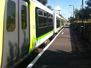
The Abbey Line, also called the St Albans Abbey branch line, is a railway line from Watford Junction to St Albans Abbey. The 6.5-mile (10.5 km) route passes through town and countryside in the county of Hertfordshire, just outside the boundaries of the Oyster Card and London fare zones. Its northern terminus in St Albans Abbey is located in the south of the city, around 1.2 kilometres (0.75 mi) away from the larger St Albans City railway station on the Midland Main Line.

St Albans City railway station, also known simply as St Albans, is one of two railway stations serving the city of St Albans in Hertfordshire, England. The 'City' station is the larger of the two, as it is on the better-connected Midland Main Line 19 miles 71 chains (32.0 km) from London St Pancras, being served by Govia Thameslink trains on the Thameslink route.
Watford North railway station is a National Rail station which serves the North Watford area in Hertfordshire, England in the United Kingdom. It is the first station on the Abbey Line, a single-track branch line which runs from Watford Junction to St Albans Abbey and is located approximately 3⁄4 mile (1.2 km) north east of Watford Junction. It is adjacent to a level crossing where the Abbey Line crosses Bushey Mill Lane.

Garston railway station serves the Garston area of Watford in Hertfordshire, England. It is the third station on the Abbey Line after Watford Junction and Watford North. The station and all trains serving it are operated by London Northwestern Railway.

Hatfield railway station serves the town of Hatfield in Hertfordshire, England. The station is managed by Great Northern. It is 17 miles 54 chains (28.4 km) measured from London King's Cross on the East Coast Main Line.
National Cycle Route 6 is a route of the National Cycle Network, running from London to the Lake District.

The Lea Valley Walk is a 50-mile (80 km) long-distance path located between Leagrave, the source of the River Lea near Luton, and the Thames, at Limehouse Basin, Limehouse, east London. From its source much of the walk is rural. At Hertford the path follows the towpath of the River Lee Navigation, and it becomes increasingly urbanised as it approaches London. The walk was opened in 1993 and is waymarked throughout using a swan logo.
National Cycle Route 12 is part of the National Cycle Network managed by the charity Sustrans. It currently has a length of 121 miles (195 km) but is incomplete. When fully constructed it will run from Enfield Lock (London) to Grimsby (Lincolnshire) in the United Kingdom.

The Dunstable Branch Lines were railway branch lines that joined the English town of Dunstable to the main lines at Leighton Buzzard and Welwyn. The two lines were under separate ownership and joined just east of the Dunstable North station.

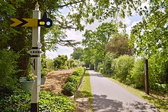
The Ayot Greenway is a rail trail which extends from Ayot St Peter, just west of Welwyn Garden City and the A1(M) Motorway to Wheathampstead in Hertfordshire. Part of National Cycle Network Route 57, it runs for three miles along a former branch line from Welwyn Garden City railway station towards Luton and Dunstable.

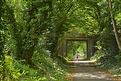
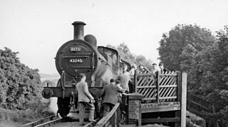
The Hatfield & St Albans Railway was a branch of the Great Northern Railway which connected St Albans to Hatfield in Hertfordshire, England. It opened in 1865 with the principal aim of allowing St Albans traffic to access the Great Northern's main line to London at Hatfield, but soon came into difficulties when the Midland Railway inaugurated a direct route to London through St Albans. Passenger receipts declined in the 1930s, resulting in the temporary withdrawal of services in 1939. Passenger services were permanently withdrawn in 1951, leaving goods traffic to linger on until December 1968. Much of the route of the line is now incorporated into the Alban Way, a footpath and cycleway.
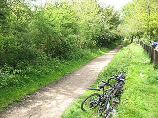
The Cole Green Way is a rail trail which runs east-west from the eastern edge of Welwyn Garden City to Hertford in Hertfordshire. Part of National Cycle Network Route 61, and the Lea Valley Walk, it runs for more than six miles along the former Hertford, Luton & Dunstable branch line from Welwyn Garden City railway station to Hertford North railway station.
Hatfield Hyde Halt was a halt-layout railway station. The station was part of the Hertford and Welwyn Junction Railway, near the garden city of Welwyn, which was established in 1920, by which time Hatfield Hyde Halt had long been closed.

The Hertford and Welwyn Junction Railway is a former railway in Hertfordshire, England, which merged in 1858 with the Luton, Dunstable and Welwyn Railway to form the Hertford, Luton and Dunstable Railway, which was then taken over by the Great Northern Railway in 1861.
The Hertford, Luton and Dunstable Railway was a railway affiliated to the Great Northern Railway. It was formed when the Hertford and Welwyn Junction Railway merged with the Luton, Dunstable and Welwyn Junction Railway, partly opened in the same year. The merger and change of title took place in 1860. The line joined the Dunstable branch of the London and North Western Railway at Dunstable.
National Cycle Route 61 is part of the National Cycle Network managed by the charity Sustrans. It runs for 34 miles from Maidenhead (Berkshire) to Hoddesdon (Hertfordshire) via Uxbridge, Watford, St Albans, Hatfield, Welwyn Garden City and Hertford in the United Kingdom.