Hill End railway station

Last updated

Hill End
HillEndStationPlatform20071231.jpg
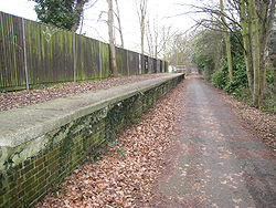
Platform remains on the Alban Way
Location St Albans, City and District of St Albans, Hertfordshire
England
Platforms1
Other information
StatusDisused
History
Opened1 August 1899
Closed1 October 1951
Original company Great Northern Railway
Pre-groupingGNR
Post-grouping London and North Eastern Railway

Hill End railway station was on the Great Northern Railway branch from Hatfield to St Albans [1] in Hertfordshire, England.

History

A 1902 Railway Clearing House map of railways in the vicinity of Hill End (lower left) Dunstable, Hertford, Hitchin & St Albans RJD 35.jpg
A 1902 Railway Clearing House map of railways in the vicinity of Hill End (lower left)

The station, which was intended to service Hill End Hospital, opened on 1 August 1899, and closed on 1 October 1951. [2]

Preceding station Disused railways Following station
Salvation Army Halt   Great Northern Railway
Hatfield and St Albans Railway
  Smallford

Related Research Articles

Sole Street railway station

Sole Street railway station is on the Chatham Main Line in England, serving the village of Sole Street, near Cobham, Kent. It is 26 miles 71 chains (43.3 km) down the line from London Victoria and is situated between Meopham and Rochester. The station is managed by Southeastern.

Meopham railway station

Meopham railway station is on the Chatham Main Line in England, serving the village of Meopham, Kent. It is 25 miles 76 chains (41.8 km) down the line from London Victoria and is situated between Longfield and Sole Street. The station is managed by Southeastern.

Letchworth Garden City railway station

Letchworth Garden City station serves the town of Letchworth in Hertfordshire, England. The station is on the Cambridge Line 34 miles 50 chains (55.7 km) north of London King's Cross, and is a stop for services between King's Cross and Cambridge. Trains which serve the station are operated by Great Northern.

Welsh Harp railway station was built by the Midland Railway in 1870 on its extension to St. Pancras station.

Old Oak Lane Halt railway station was the first station on the "New North Main Line" of the Great Western Railway. It served the area between North Acton and Old Oak Common, and was in use between 1906 and 1947. At least one of the platform shelters was of the Pagoda pattern.

Fishponds railway station Railway station building

Fishponds railway station was a station in Fishponds, Bristol, England, a victim of Dr Beeching's cuts in the 1960s.

Hawkhurst railway station

Hawkhurst railway station was on the closed Hawkhurst Branch in Kent, England.

Horsmonden railway station

Horsmonden is a closed railway station on the closed Hawkhurst Branch in Kent, England.

Goudhurst railway station

Goudhurst is a closed railway station on the closed Hawkhurst Branch in Kent, England.

Cranbrook railway station (Kent)

Cranbrook railway station is a disused English station which was on the closed Hawkhurst Branch in Kent, England.

Harlesden railway station (Midland Railway)

Harlesden (Midland) railway station was a station in northwest London on the south side of the southern section of a road called Craven Park, which is part of the A404 Harrow Road between Paddington and Wembley. The station was sometimes known as Harrow Road or as Stonebridge Park.

Winchester (Chesil) railway station Disused railway station in Hampshire, England

Winchester (Chesil) railway station was, for the first six years after the opening of the line, the terminus of the Didcot, Newbury and Southampton Railway (DNSR), until the line was extended to link up with the Southern Railway line to Southampton. The station buildings were larger than those of any other DNSR station but were built to the standard designs used by the Great Western Railway (GWR). The station buildings were located on the northbound platform. At the northern end of the station the line passed into the double tracked Chesil tunnel. The station also included a loading bay and single siding at its southern end accessible from the northbound line.

Devonshire Street was a short-lived railway station in the parish of Mile End Old Town, in the East End of London. It was opened on 20 June 1839 as a temporary London terminus of the Eastern Counties Railway (ECR) from Romford prior to the construction of Shoreditch station which became the permanent terminus.

Ebley Crossing Halt railway station

Ebley Crossing Halt was opened on 12 October 1903 on what is now the Golden Valley Line between Stroud and Stonehouse. This line was opened in 1845 as the Cheltenham and Great Western Union Railway from Swindon to Gloucester and this was one of many small stations and halts built on this line for the local passenger service.

Churchdown railway station

Churchdown railway station was situated on the main line between Gloucester and Cheltenham Spa. It served Churchdown and surrounding areas.

Trumpers Crossing Halte railway station

Trumpers Crossing Halte was a station of scant construction on the Brentford Branch Line of the Great Western Railway, which ran from Southall to Brentford Dock.

Cheltenham Spa Malvern Road railway station

Cheltenham Spa Malvern Road railway station was a station in the town of Cheltenham.

Hertford Cowbridge railway station

Hertford Cowbridge railway station was a station on the Hertford and Welwyn Junction Railway, and was situated in Hertford, England.

Stapleford railway station

Stapleford railway station was a station on the Hertford Loop Line, and was situated in the village of Stapleford, Hertfordshire, England.

Wembley Exhibition railway station

Exhibition Station (Wembley) was a railway station in Wembley Park in what is now the London Borough of Brent. It was built on a spur to connect the 1924-5 British Empire Exhibition to London Marylebone.

References

  1. Conolly, W. Philip (January 1976). British Railways Pre-Grouping Atlas and Gazetteer (5th ed.). Shepperton: Ian Allan. p. 11, section F2. ISBN   0-7110-0320-3. EX/0176.
  2. Butt, R.V.J. (1995). The Directory of Railway Stations. Yeovil: Patrick Stephens Ltd. p. 120. ISBN   1-85260-508-1. R508.

Coordinates: 51°44′57″N0°17′48″W / 51.7492°N 0.2968°W / 51.7492; -0.2968