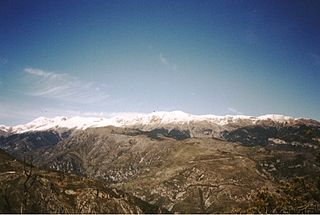
The Maritime Alps are a mountain range in the southwestern part of the Alps. They form the border between the French region of Provence-Alpes-Côte d'Azur and the Italian regions of Piedmont and Liguria. They are the southernmost part of the Alps.

The Cottian Alps are a mountain range in the southwestern part of the Alps. They form the border between France and Italy (Piedmont). The Fréjus Road Tunnel and Fréjus Rail Tunnel between Modane and Susa are important transportation arteries between France and Italy (Turin).

The Engadin or Engadine is a long high Alpine valley region in the eastern Swiss Alps in the canton of Graubünden in southeasternmost Switzerland with about 25,000 inhabitants. It follows the route of the Inn from its headwaters at Maloja Pass in the southwest running roughly northeast until the Inn flows into Austria, little less than one hundred kilometers downstream. The En/Inn subsequently flows at Passau into the Danube, making it the only Swiss river to drain into the Black Sea. The Engadine is protected by high mountain ranges on all sides and is famous for its sunny climate, beautiful landscapes and outdoor activities.

The Great St Bernard Pass is the third highest road pass in Switzerland, at an elevation of 2,469 m (8,100 ft). It connects Martigny in the canton of Valais in Switzerland with Aosta in the region Aosta Valley in Italy. It is the lowest pass lying on the ridge between the two highest mountains of the Alps, Mont Blanc and Monte Rosa. It is located on the main watershed that separates the basin of the Rhône from that of the Po.

The Gotthard Pass or St. Gotthard Pass at 2,106 m (6,909 ft) is a mountain pass in the Alps traversing the Saint-Gotthard Massif and connecting northern Switzerland with southern Switzerland. The pass lies between Airolo in the Italian-speaking canton of Ticino, and Andermatt in the German-speaking canton of Uri, and connects further Bellinzona and Lugano to Lucerne, Basel, and Zürich. The Gotthard Pass lies at the heart of the Gotthard, a major transport axis of Europe, and it is crossed by three traffic tunnels, each being the world's longest at the time of their construction: the Gotthard Rail Tunnel (1882), the Gotthard Road Tunnel (1980) and the Gotthard Base Tunnel (2016). With the Lötschberg to the west, the Gotthard is one of the two main north-south routes through the Swiss Alps.

The Maddalena Pass is a high mountain pass between the Cottian Alps and the Maritime Alps, located on the border between Italy and France. It connects Barcelonnette in France with Cuneo in Italy. Its French name Col de Larche refers to the village Larche on its northwestern side.

The Bernese Oberland, sometimes also known as the Bernese Highlands, is the highest and southernmost part of the canton of Bern. It is one of the canton's five administrative regions. It constitutes the Alpine region of the canton and the northern side of the Bernese Alps, including many of its highest peaks, among which the Finsteraarhorn, the highest in both range and canton.

The Splügen Pass is an Alpine mountain pass of the Lepontine Alps. It connects the Swiss, Grisonian Splügen 5 kilometres (3.1 mi) to the north 675 metres (2,215 ft) below the pass with the Italian Chiavenna 21 kilometres (13 mi) to the south at the end of the Valle San Giacomo 1,789 metres (5,869 ft) below the pass.

Umbrail Pass is a high mountain pass on the Swiss-Italian border connecting Santa Maria in Val Müstair with Bormio in the Adda valley. On the Italian side, it connects to the Stelvio Pass road and the Valtellina. It is currently the highest paved road in Switzerland.

Timmelsjoch, is a high mountain pass that creates a link through the Ötztal Alps along the border between Austria and Italy.

Monte Leone is the highest mountain of the Lepontine Alps and is located on the border between Switzerland and Italy. The mountain stands on the extreme west of the Lepontine Alps, a few kilometres east of Simplon Pass.

The Autostrada A26 is an autostrada 197.1 kilometres (122.5 mi) long in Italy located in the regions of Liguria and Piedmont. It is named the Autostrada dei Trafori after the numerous tunnels through which it passes, both Apennine and Subalpine. It runs northwards from Genoa on the Ligurian coast, over the Apennines, and across the wide plain of the Po valley to the environs of Lake Maggiore and the mouth of the Val d’Ossola. In addition to this ‘main trunk’ of the road, there are three side branches, also of motorway class which function as link roads between the A26 and the A7, the A4 and the A8. The A26, together with these link roads, is managed by Autostrade per l'Italia S.p.A. It is a part of the E25 and E62 European routes.

The Ofenhorn is a mountain of the Lepontine Alps on the Swiss-Italian border. It is located between the valleys of Binn and Formazza.

The Albrunhorn is a mountain of the Lepontine Alps on the Swiss-Italian border. It overlooks the Albrun Pass.

The Binn Valley is a valley of the Alps, located on the north side of the Lepontine Alps in the Swiss canton of Valais. The valley is drained by the Binna, a tributary of the Rhone, at Grengiols. The valley is named after Binn, the main settlement. Other villages or localities are Ausserbinn, Heiligkreuz and Fäld.

The Stelvio Pass is a mountain pass in northern Italy bordering Switzerland at an elevation of 2,757 m (9,045 ft) above sea level. It is the highest paved mountain pass in the Eastern Alps, and the second highest in the Alps, 7 m (23 ft) below France's Col de l'Iseran.

The San Giacomo Pass is an Alpine pass connecting Switzerland and Italy. It connects Bedretto on its northern side to Formazza on its southern side.
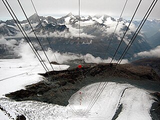
The Theodul Glacier is a glacier of the Alps, located south of Zermatt in the canton of Valais. It lies on the Swiss side of the Pennine Alps, although its upper basin touches the Italian region of the Aosta Valley. The glacier descends from the west side of the Breithorn and splits into two diverging branches above Gandegg: the Upper Theodul Glacier, spilling on a high plateau near Trockener Steg, together with the Furgg Glacier, and the Lower Theodul Glacier, reaching a height of about 2,500 metres (8,202 ft) above the Gorner Glacier.

Hagazussa: A Heathen's Curse is a 2017 German-Austrian horror film written and directed by Lukas Feigelfeld in his feature directorial debut, and produced by Feigelfeld and Simon Lubinski. The film follows Aleksandra Cwen as goat-herder Albrun, who leads a secluded life in a remote part of the 15th-century Alps, an area which is fraught by belief in witches and fear of heathens and other non-Christian cultures.

