Since the Middle Ages, transit across the Gotthard played an important role in Swiss history, the region north of the Gotthard becoming the nucleus of the Swiss Confederacy in the 13th century, after the pass became a vital trade route between Northern and Southern Europe.[1] The Gotthard is sometimes referred to as the "King of Mountain Passes" because of its central and strategic location.[2][3]
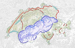
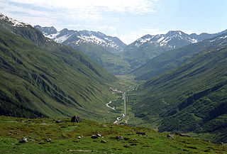
The Gotthard Pass lies on the main watershed of the Gotthard massif, a massif lying at the heart of the Swiss Alps, between the cantons of Valais, Ticino, Grisons and Uri. The pass itself is the lowest point between the summits of Pizzo Lucendro (west) and Pizzo Centrale (east). It connects the cantons of Uri (north) and Ticino (south), its summit (2,106 metres (6,909ft), indicated by a road sign) being located in the latter canton, about 2km south of the border with Uri. The valleys connected by the pass are that of the river Reuss, named the Urseren, and that of the river Ticino, named Valle Leventina. The Gotthard axis is the most important route between Central Switzerland as well as most of the northern part of the country and the southern region of Ticino. It is the most direct link between Zürich and Lugano and also between some regions of northern Europe and Italy (Rotterdam-Basel-Genoa axis).
The nearest towns are Hospental (7km north) near Andermatt and Airolo (4km south), respectively in the valleys of Urseren and Leventina. The region of Andermatt lies at the foot of the Furka and Oberalp Passes connecting the Rhone and Rhine Valleys thus making the Gotthard area a strategic place for transports and military (the Swiss Réduit for instance).
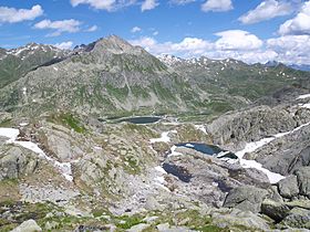
Lago della Piazza and Hospice area
Just southeast of the culminating point of the Gotthard Pass, at an elevation of about 2,090 metres above sea level, are several lakes. The largest is named Lago della Piazza and has a surface of 3.94 hectares. South of Lago della Piazza are the Hospice (Italian: Ospizio) and National Museum, as well as a hotel and restaurants. Another official road sign displaying an elevation of 2,091 metres (6,860ft) lies there.
A few kilometres away and slightly above the Gotthard Pass are found two large dams and artificial lakes: Lago di Lucendro at the foot of Pizzo Lucendro and Lago della Sella at the foot of Pizzo Centrale. They are respectively part of the Reuss and Ticino basin, although both are located within the canton of Ticino.
Though the pass was locally known in antiquity, it was not generally used until the early 13th century because travel involved fording the turbulent Reuss, swollen with snowmelt during the early summer, in the narrow steep-sided Schöllenen Gorge, below Andermatt.
The first wooden bridge across Schöllenen Gorge was built around 1220, and in the following years the pass rapidly gained in importance.
The bridge permitted traffic to follow the Reuss to its headwaters and over the saddle at the top—a continental divide between the Rhine, which flows into the North Sea, and the river Ticino towards Milan, which after leaving Switzerland flows into the Po and ultimately into the Adriatic Sea.
The Gotthard Pass was formerly known as Monte Tremolo (its southern slope is still known as Val Tremola).[citation needed]
A chapel dedicated to Saint Gotthard of Hildesheim (died in 1038, canonized 1131), who was considered the patron saint of mountain passes, was built on the southern slope of the pass and consecrated by the archbishop of Milan, Enrico da Settala, in 1230.[4] The pass soon became known after the saint, by as early as 1236.
The opening of the Schöllenen Gorge for traffic was an important factor in the original Swiss Confederacy. The three regions of Uri, Schwyz and Unterwalden (the Waldstätten or "forest communities") gained imperial immediacy under the Hohenstaufen emperors still in the first half of the 13th century. An important aspect of the early confederacy, expressed in the Pfaffenbrief of 1370, was the guarantee of peace along the road from Zürich to the Gotthard Pass.
The Swiss also had an interest in extending their influence south of the Alps to secure the trade route across the pass to Milan. Beginning in 1331, they initially exerted their influence through peaceful trade agreements, but in the 15th century, their involvement turned military. 1403 the upper Leventina, as the valley south of the pass is called, became a protectorate of Uri. Throughout the 15th century, a changeful struggle between the Swiss and the Duchy of Milan ensued, resulting ultimately in the Swiss conquest of the territory of the Ticino.
The "Devil's Bridge" (Teufelsbrücke) legend associated with the crossing of the Schöllenen Gorge is not medieval; it may date to the 16th century (attestation of the name Teiffels Brucken in 1587) but more likely formed in the 17th century, and is first recorded in the early 18th century, by Johann Jakob Scheuchzer.[5]
A new road, including a tunnel with a length of c. 60 m, was built in 1707/8. The tunnel, known as Urnerloch, was the first road tunnel to be built in the Alps. It was constructed by Pietro Morettini (1660–1737).
The path across Schöllenen Gorge, and thus across the pass, still carried only foot traffic and pack animals until 1775,[citation needed] when the first carriage made the journey on an improved road.[citation needed]
The new Gotthard road was built in 1830,[citation needed] wide enough to allow (single-lane) motorized traffic. It is said[by whom?] that the first car traversed the pass in 1895. The first reported[where?] surmounting of the pass in 1901 still took more than a day.
With the Gotthard Road Tunnel (opened in 1980) the pass itself was again reduced to limited importance for traffic.
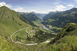
Crossing the Gotthard
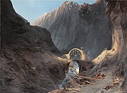
The modern concrete span of the third Devil's Bridge (Teufelsbrücke, built 1958) showing an older bridge (built 1830) below
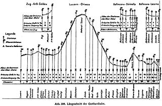
In addition to the National Road 2, crossing the pass and connecting Göschenen with Airolo, several tunnels provide access through the massif. The first one, the 15 kilometres (9.3mi)Gotthard Rail Tunnel, opened in 1882 for railway traffic at a cost of around 200 workers' lives (there is uncertainty as to the exact toll).[6] The second one, the 17 kilometres (11mi)Gotthard Road Tunnel (a motorway tunnel), opened in 1980. It was closed for two months in 2001 following a fatal fire. Both railway and motorway tunnels have portals in Göschenen and Airolo, at around 1,150 metres above sea level, and are close to each other. Either rail and road traffics through these tunnels are sometimes shut down during harsh weather conditions, particularly in winter.
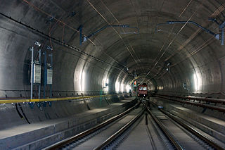
The last tunnel, the 57 kilometres (35mi)Gotthard Base Tunnel (a double-tube railway tunnel), opened in 2016. At around 500 metres above sea level, it provides for the first time a flat route through the massif and the Alps from the northern plains at Erstfeld to the southern plains at Bodio. It is the longest and deepest railway tunnel in the world. This tunnel, combined with two shorter tunnels planned near Zürich and Lugano as part of the NRLA project, reduced the 3 hour 40 min rail journey from Zürich to Milan by one hour, while increasing the size and number of trains that can operate along the route because the line is nearly level, compared with the spirals of the older tunnel.
Clausewitz, Carl von (2020). Napoleon Absent, Coalition Ascendant: The 1799 Campaign in Italy and Switzerland, Volume 1. Trans and ed. Nicholas Murray and Christopher Pringle. Lawrence, Kansas: University Press of Kansas. ISBN978-0-7006-3025-7.
Clausewitz, Carl von (2021). The Coalition Crumbles, Napoleon Returns: The 1799 Campaign in Italy and Switzerland, Volume 2. Trans and ed. Nicholas Murray and Christopher Pringle. Lawrence, Kansas: University Press of Kansas. ISBN978-0-7006-3034-9.
The Lepontine Alps are a mountain range in the north-western part of the Alps. They are located in Switzerland and Italy.
Ticino, sometimes Tessin, officially the Republic and Canton of Ticino or less formally the Canton of Ticino, is one of the 26 cantons forming the Swiss Confederation. It is composed of eight districts and its capital city is Bellinzona. It is also traditionally divided into the Sopraceneri and the Sottoceneri, respectively north and south of Monte Ceneri. Red and blue are the colours of its flag.
The river Ticino is the most important perennial left-bank tributary of the Po. It has given its name to the Swiss canton through which its upper portion flows.
The canton of Uri is one of the 26 cantons of Switzerland and a founding member of the Swiss Confederation. It is located in Central Switzerland. The canton's territory covers the valley of the Reuss between the St. Gotthard Pass and Lake Lucerne.
The Reuss is a river in Switzerland. With a length of 164 kilometres (102 mi) and a drainage basin of 3,426 square kilometres (1,323 sq mi), it is the fourth largest river in Switzerland. The upper Reuss forms the main valley of the canton of Uri. The course of the lower Reuss runs from Lake Lucerne to the confluence with the Aare at Brugg and Windisch.
The Gotthard Base Tunnel is a railway tunnel through the Alps in Switzerland. It opened in June 2016 and full service began the following December. With a route length of 57.09 km (35.5 mi), it is the world's longest railway and deepest traffic tunnel and the first flat, low-level route through the Alps. It lies at the heart of the Gotthard axis and constitutes the third tunnel connecting the cantons of Uri and Ticino, after the Gotthard Tunnel and the Gotthard Road Tunnel.
The Gotthard Road Tunnel in Switzerland runs from Göschenen in the canton of Uri at its northern portal, to Airolo in Ticino to the south, and is 16.9 kilometres (10.5 mi) in length below the St Gotthard Pass, a major pass of the Alps. At time of construction, in 1980, it was the longest road tunnel in the world; it is currently the fifth-longest. Although it is a motorway tunnel, part of the A2 from Basel to Chiasso, it consists of only one bidirectional tube with two lanes. With a maximum elevation of 1,175 metres (3,855 ft) at the tunnel's highest point, the A2 motorway has the lowest maximum elevation of any direct north-south road through the Alps.
Gotthard or Saint Gotthard may refer to:
Andermatt is a mountain village and municipality in the canton of Uri in Switzerland. At an elevation of 1,437 meters (4,715 ft) above sea level, Andermatt is located at the center of the Saint-Gotthard Massif and the historical center cross of north-south and east-west traverses of Switzerland. It is some 28 km (17 mi) south of Altdorf, the capital of Uri.
Schöllenen Gorge is a gorge formed by the upper Reuss in the Swiss canton of Uri between the towns of Göschenen to the north and Andermatt to the south. It provides access to the St Gotthard Pass.
The Gotthard Tunnel is a 15-kilometre-long (9.3 mi) railway tunnel that forms the summit of the Gotthard Railway in Switzerland. It connects Göschenen with Airolo and was the first tunnel through the Saint-Gotthard Massif in order to bypass the St Gotthard Pass. It was built as single bore tunnel accommodating a standard gauge double-track railway throughout. When opened in 1882, the Gotthard Tunnel was the longest tunnel in the world.
The Gotthard railway, named after the Saint-Gotthard Massif which it crosses, is the Swiss trans-alpine railway line from northern Switzerland to the canton of Ticino. The line forms a major part of an important international railway link between northern and southern Europe, especially on the Rotterdam-Basel-Genoa corridor. The Gotthard Railway Company was the former private railway company that financed the construction of and originally operated that line.
The Gotthard Massif or Saint-Gotthard Massif is a mountain range in the Alps in Switzerland, located at the border of four cantons: Valais, Ticino, Uri and Graubünden. It is delimited by the Nufenen Pass on the west, by the Furka Pass and the Oberalp Pass on the north and by the Lukmanier Pass on the east. The eponymous Gotthard Pass, lying at the heart of the massif, is the main route from north to south.
Göschenen railway station is a railway station in the Swiss canton of Uri and municipality of Göschenen. Situated on the original line of the Gotthard railway, at the northern mouth of the Gotthard Tunnel, the station is also the junction point with the Schöllenenbahn. Most trains on the Gotthard route now use the Gotthard Base Tunnel and do not pass through Göschenen station.
Lugano railway station is the main railway station of the city of Lugano, in the Swiss canton of Ticino. The station is on the Gotthard railway and is also the terminus of the Lugano Città–Stazione funicular. The metre gauge Lugano–Ponte Tresa Railway (FLP) has a separate station at Lugano FLP railway station across the station forecourt from the main line station.
The Swiss National Redoubt is a defensive plan developed by the Swiss government beginning in the 1880s to respond to foreign invasion. In the opening years of the Second World War the plan was expanded and refined to deal with a potential German invasion. The term "National Redoubt" primarily refers to the fortifications begun in the 1880s that secured the mountainous central part of Switzerland, providing a defended refuge for a retreating Swiss Army.
Airolo railway station is a railway station in the Swiss canton of Ticino and municipality of Airolo. The station is on the original line of the Swiss Federal Railways Gotthard railway, at the southern entrance to the Gotthard Tunnel. Most trains on the Gotthard route now use the Gotthard Base Tunnel and do not pass through Airolo station.
Uri is a Swiss Talschaft and canton in the upper Reuss valley.
The Tremola San Gottardo, located in the Canton of Ticino, is the longest road monument in Switzerland and is listed in the inventory of the historic Swiss roads (IVS). It connects the municipality of Airolo to the Gotthard Pass.
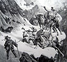
The battle of (the) Gotthard Pass, also known as the battle of the St. Gotthard Pass or the battle of the St. Gotthard, saw an Imperial Russian army commanded by Field Marshal Alexander Suvorov supported by two Austrian brigades attack a French division under General of Division Claude Lecourbe. The same day brought clashes at the Oberalp Pass and Hospental.
References
↑ Anna Roos (2017). Swiss Sensibility: The Culture of Architecture in Switzerland. Birkhäuser. p.6. ISBN9783035609226. For thousands of years the Gotthard Pass has been an important threshold between north and south Europe and for many centuries has played a significant role in the economy and culture of central Switzerland. Since the early thirteenth century, the pass has been a vital trade route connecting different cultures and language regions.
↑ Radaelli, Giulia; Thurn, Nike (2019). Gegenwartsliteratur - Weltliteratur: Historische und theoretische Perspektiven. Bielefeld: Transcript Verlag. p.251. ISBN9783839433652. ...zwischen 1218 und 1231 ansetzen könne, und just in jenen Interdezennien sei ja die Schöllenen bezwungen worden, die Teufelsbrücke gebaut und der König der Pässe, das royale Zentralalpenmassiv, dem Transitverkehr erschlossen worden...[...could start between 1218 and 1231, and it was precisely in those interdecades that the Schöllenen was conquered, the Teufelsbrücke was built and the king of passes, the royal massif in the central Alps, was opened up to transit traffic...]
↑ Bruno Meier, Von Morgarten bis Marignano (2015), p. 23.
This page is based on this Wikipedia article Text is available under the CC BY-SA 4.0 license; additional terms may apply. Images, videos and audio are available under their respective licenses.


 The modern concrete span of the third Devil's Bridge ( Teufelsbrücke , built 1958) showing an older bridge (built 1830) below
 Gotthard Post near the summit
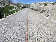 Old road: summit of the Gotthard
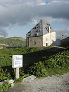 Gotthard Hospice
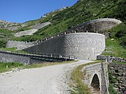
 Tremola valley