The geography of Switzerland features a mountainous and landlocked country located in Western and Central Europe. Switzerland's natural landscape is marked by its numerous lakes and mountains. It is surrounded by five countries: Austria and Liechtenstein to the east, France to the west, Italy to the south and Germany to the north. Switzerland has a maximum north–south length of 220 kilometres (140 mi) and an east–west length of about 350 kilometres (220 mi).

The Alpine region of Switzerland, conventionally referred to as the Swiss Alps, represents a major natural feature of the country and is, along with the Swiss Plateau and the Swiss portion of the Jura Mountains, one of its three main physiographic regions. The Swiss Alps extend over both the Western Alps and the Eastern Alps, encompassing an area sometimes called Central Alps. While the northern ranges from the Bernese Alps to the Appenzell Alps are entirely in Switzerland, the southern ranges from the Mont Blanc massif to the Bernina massif are shared with other countries such as France, Italy, Austria and Liechtenstein.

The Pennine Alps, sometimes referred to as the Valais Alps, are a mountain range in the western part of the Alps. They are located in Italy and Switzerland (Valais).

The Graian Alps are a mountain range in the western part of the Alps.

The river Ticino is the most important perennial left-bank tributary of the Po. It has given its name to the Swiss canton through which its upper portion flows.

Valais, more formally, the Canton of Valais, is one of the 26 cantons forming the Swiss Confederation. It is composed of thirteen districts and its capital and largest city is Sion.

The Jungfrau, at 4,158 meters (13,642 ft) is one of the main summits of the Bernese Alps, located between the northern canton of Bern and the southern canton of Valais, halfway between Interlaken and Fiesch. Together with the Eiger and Mönch, the Jungfrau forms a massive wall of mountains overlooking the Bernese Oberland and the Swiss Plateau, one of the most distinctive sights of the Swiss Alps.

The Diablerets are a huge ice-covered mountain massif of the Alps, culminating at the Sommet des Diablerets (VS) at 3,216 metres (10,551 ft) above sea level and almost straddling the border between the Swiss cantons of Vaud (VD) and Valais (VS). The northeastern part of the massif stretches also into the canton of Bern (BE).

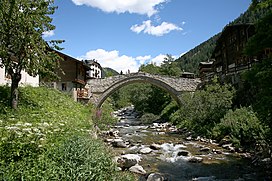
Binn is a municipality in the district of Goms in the canton of Valais in Switzerland.

Monte Rosa is a mountain massif in the eastern part of the Pennine Alps, on the border between Italy and Switzerland (Valais). The highest peak of the massif, amongst several peaks of over 4,000 m (13,000 ft), is the Dufourspitze, the second highest mountain in the Alps and western Europe, after Mont Blanc. The east face of the Monte Rosa towards Italy has a height of about 2,400 metres (7,900 ft) and is the highest mountain wall of the Alps.

The Helsenhorn is a mountain of the Lepontine Alps, overlooking Binn in the Swiss canton of Valais. With a height of 3,272 metres above sea level, it is the highest summit of the Binntal. The border with Italy runs approximately 200 metres south-east of the summit and culminates at 3,247 metres.

The Lengenbach Quarry is located in the Binn Valley and it is noted among the mineralogical community for its unusual sulfosalt mineral specimens.
Schwarzhorn may refer to mountains/peaks in:

The Lötschberg is an Alpine mountain massif, usually associated with a major, historically important transit axis of the Alps in Switzerland with, at its core, the Lötschen Pass. The mountain pass, which culminates at nearly 2,700 metres above sea level, are part of the eastern Bernese Alps, whose main crest straddles the border between the cantons of Bern and Valais. The valleys concerned by the Lötschberg are those of the Kander in the Berner Oberland, with Kandersteg at the head of it, and a secluded side-valley of the Upper Valais, the Lötschental, with Ferden at the valley's entrance and at the bottom of the pass.
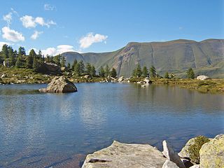
Mässersee is the smallest of four mountain lakes in the upper Binntal of the canton of Valais, Switzerland.

The Jungfrau-Aletsch protected area is located in south-western Switzerland between the cantons of Bern and Valais. It is a mountainous region in the easternmost side of the Bernese Alps, containing the northern wall of Jungfrau and Eiger, and the largest glaciated area in western Eurasia, comprising the Aletsch Glacier. The Jungfrau-Aletsch protected area is the first World Natural Heritage site in the Alps; it was inscribed in 2001.
The Albrun Pass is an Alpine pass connecting Switzerland and Italy. It connects Binn in the Binntal on its northern side to Baceno on its southern side. The Albrun Pass is the lowest pass on the main chain of the Alps between the Simplon Pass and the Gotthard Pass.

The Simplon Valley or Divedro Valley is a valley of the Alps, situated between the Pennine and the Lepontine ranges. The valley is drained by the Diveria or Chrummbach, a tributary of the Toce at Crevoladossola. The Simplon Valley is the only valley of Valais located south of the main chain of the Alps.
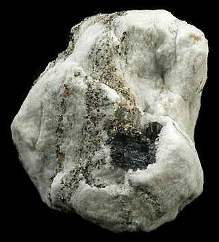
Sartorite is a lead arsenic sulfide with the chemical formula PbAs2S4 and as type locality the Lengenbach Quarry in Legenbach, Binnental, Valais, Switzerland. Historically, sartorite has been thought isomorphic to chalcostibite, emplectite, and zinckenite, but was definitively distinguished from the others in 1939.