
The Diablerets are a huge ice-covered mountain massif of the Alps, culminating at the Sommet des Diablerets at 3,210 metres (10,530 ft) above sea level and straddling the border between the Swiss cantons of Vaud (VD) and Valais (VS). The northeastern part of the massif stretches also into the canton of Bern (BE).

The Brienzer Rothorn is a mountain of the Emmental Alps, in Switzerland. With an elevation of 2,350 metres (7,710 ft) above sea level, the Brienzer Rothorn is the highest summit of the range. To its west lies the Tannhorn, whilst to its east are Arnihaaggen, Höch Gumme and the Brünig Pass. On its south side it overlooks Lake Brienz, whilst to the north it looks out over the Waldemme valley.

Mount Nebo is the southernmost and highest mountain in the Wasatch Range of Utah, in the United States, and the centerpiece of the Mount Nebo Wilderness, inside the Uinta National Forest. It is named after the biblical Mount Nebo, overlooking Israel from the east of the Jordan river, which is said to be the place of Moses' death.

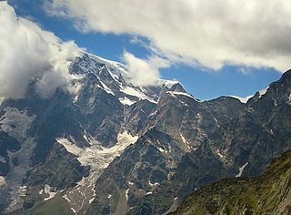
Monte Rosa is a mountain massif in the eastern part of the Pennine Alps. It is between Italy's and Switzerland's (Valais). Monte Rosa is the second highest mountain in the Alps and western Europe, after Mont Blanc.
The Jägerhorn is a mountain of the Pennine Alps, located on the border between Switzerland and Italy. It lies just north of Monte Rosa, at a height of 3,970 metres above sea level, and overlooks the village of Macugnaga on its east side, 2,600 metres below. On its west side it overlooks the Gorner Glacier.

The Gornergrat is a rocky ridge of the Pennine Alps, overlooking the Gorner Glacier south-east of Zermatt in Switzerland. It can be reached from Zermatt by the Gornergrat rack railway (GGB), the highest open-air railway in Europe. Between the Gornergrat railway station and the summit is the Kulm Hotel. In the late 1960s two astronomical observatories were installed in the two towers of the Kulmhotel Gornergrat. The project “Stellarium Gornergrat” is hosted in the Gornergrat South Observatory.

Lambrigg Fell is a hill, the highest point of the area of high ground between Kendal and the M6, in south-eastern Cumbria, England.

The Gross Windgällen is a 3,187 m high mountain in the Glarus Alps, overlooking the valley of the Reuss in the canton of Uri. The name Gross Windgällen derives from Gälle or gellen, meaning as much as wailing, shrilling or whistling.
The Sustenhorn is a 3,502-metre-high (11,490 ft) mountain in the Uri Alps, located on the border between the cantons of Bern and Uri. It overlook Susten Pass from the south.

The Ringelspitz is a mountain of the Glarus Alps, located on the border between the Swiss cantons of St. Gallen and Graubünden. Reaching a height of 3,248 metres above sea level, it is the highest summit in the canton of St. Gallen. It is split between three municipalities: Pfäfers, Trin and Tamins (Graubünden).

Piz Terri is a mountain in the Lepontine Alps, located on the border between the cantons of Ticino and Graubünden. At 3,149 metres above sea level it is the highest summit lying on the chain between Greina and Soreda Pass. Piz Terri overlooks Lake Luzzone in Val Blenio on its west side, Val Sumvitg on its north side and Lumnezia on its east side. Close localities are Olivone and Vrin (Lumnezia).

The Vogelberg is a 3,218 metres high mountain of the Lepontine Alps, located on the border between the Swiss cantons of Ticino and Graubünden. It is the highest summit of the Lepontine Alps south of the Rheinwaldhorn. The Vogelberg is a large glaciated massif consisting of several secondary summits: Pizzo Cramorino on the west side and Rheinquellhorn on the east. The northern flanks are covered by the Paradies Glacier at the source of the Hinterrhein. The southern side, overlooking the valley of Malvaglia (Ticino) is steeper and has no glaciers.

Cima Rossa is a 3,161 metres high mountain in the Lepontine Alps, located on the border between the cantons of Ticino and Graubünden. On the west side it overlooks the valley of Malvaglia (Ticino) and on the east side it overlooks the valley of Calanca (Graubünden).

The Diechterhorn is a mountain in the Urner Alps, overlooking the Haslital in the Bernese Oberland. At 3,389 metres above sea level it is the highest summit of the Urner Alps lying within the canton of Bern.

The Fleckistock is a 3,417 metres high mountain in the Urner Alps, overlooking Wassen in the canton of Uri. It is the highest summit of the group lying east of the pass of Sustenjoch. This range, starting at the Stucklistock and ending at the Salbitschijen, separates the valleys of Voralp, above Göschenen and Meiental, above Wassen.
The Pointe des Plines is a minor peak on the east edge of the Mont Blanc massif, close to the Aiguille Dorees, and overlooking the Saleina Glacier in the canton of Valais.

The Ruchi is a mountain in the Glarus Alps, located at an elevation of 3,107 m (10,194 ft) on the border between the Swiss cantons of Glarus and Graubünden. It overlooks the Muttsee on its west side from where a trail leads to the summit. On its south-east side lies a small glacier, the Glatscher da Gavirolas. The Ruchi is connected to the higher summit of the Hausstock on the north-east by a 2 km (1.2 mi) long ridge.

Piz Pisoc is a mountain in the Sesvenna Range of the Alps, overlooking Tarasp in the Swiss canton of Graubünden. With an elevation of 3,173 metres above sea level, it is the highest summit of the Sesvenna Range west of Pass Costainas and the second highest summit of the whole range.

The Binn Valley is a valley of the Alps, located on the north side of the Lepontine Alps in the Swiss canton of Valais. The valley is drained by the Binna, a tributary of the Rhone, at Grengiols. The valley is named after Binn, the main settlement. Other villages or localities are Ausserbinn, Heiligkreuz and Fäld.

Le Toûno is a mountain of the Pennine Alps, overlooking Saint-Luc in the canton of Valais. It lies within the Val d'Anniviers, west of the Pointe de Tourtemagne.

